File:Oiunyt.jpg
跳至導覽
跳至搜尋

預覽大小:800 × 533 像素。 其他解析度:320 × 213 像素 | 640 × 427 像素 | 1,024 × 683 像素 | 1,280 × 853 像素 | 2,560 × 1,707 像素 | 3,456 × 2,304 像素。
原始檔案 (3,456 × 2,304 像素,檔案大小:11.32 MB,MIME 類型:image/jpeg)
說明
說明
添加單行說明來描述出檔案所代表的內容
摘要
[編輯]
| 描述 |
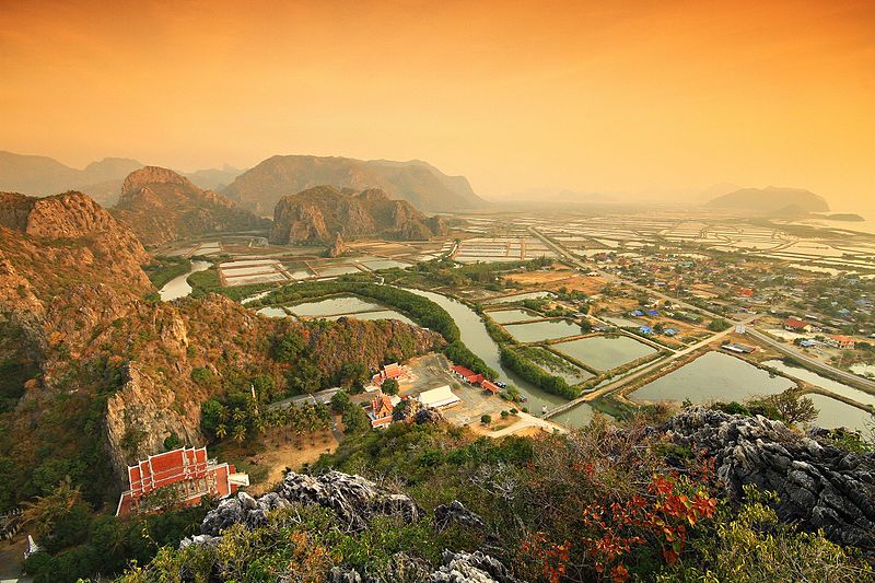
English: Khao Sam Roi Yot National Park Prachuap Khiri Khan Thailand
Khao Sam Roi Yot means "mountain with 300 peaks". The limestone hills are a subrange of the Tenasserim Hills that arise at the shore of the Gulf of Thailand, with the highest elevation being Khao Krachom at 605 m. Between the hills are freshwater marshes. Several of these marshes were converted into shrimp farms, as only 36 km2 of the total 69 km2 of marshes are part of the national park. A portion, 18 km2, of these marshes are scheduled to be declared a Ramsar site.
|
||
| 日期 | 2011年1月10日, 07:14:34 (根據EXIF的資料) | ||
| 來源 | 自己的作品 | ||
| 作者 | KOSIN SUKHUM |
授權條款
[編輯]
我,本作品的著作權持有者,決定用以下授權條款發佈本作品:
此檔案採用創用CC 姓名標示-相同方式分享 4.0 國際授權條款。
- 您可以自由:
- 分享 – 複製、發佈和傳播本作品
- 重新修改 – 創作演繹作品
- 惟需遵照下列條件:
- 姓名標示 – 您必須指名出正確的製作者,和提供授權條款的連結,以及表示是否有對內容上做出變更。您可以用任何合理的方式來行動,但不得以任何方式表明授權條款是對您許可或是由您所使用。
- 相同方式分享 – 如果您利用本素材進行再混合、轉換或創作,您必須基於如同原先的相同或兼容的條款,來分布您的貢獻成品。
此圖片是維基愛地球2016的上傳作品。
|
 |
檔案歷史
點選日期/時間以檢視該時間的檔案版本。
| 日期/時間 | 縮圖 | 尺寸 | 使用者 | 備註 | |
|---|---|---|---|---|---|
| 目前 | 2016年6月17日 (五) 18:12 | | 3,456 × 2,304(11.32 MB) | KOSIN SUKHUM(留言 | 貢獻) | Khao Sam Roi Yot National Park Prachuap Khiri Khan Thailand |
| 2016年6月17日 (五) 18:04 |  | 1,500 × 1,000(1.69 MB) | KOSIN SUKHUM(留言 | 貢獻) | User created page with UploadWizard |
無法覆蓋此檔案。
檔案用途
下列9個頁面有用到此檔案:
- User:John Cummings/exhibition/natural
- User:John Cummings/sandboximages5
- Commons:Wiki Loves Earth 2016/Winners
- Commons:Wiki Loves Earth 2016 in Thailand/Final
- Commons:Wiki Loves Earth 2016 in Thailand/First round
- Commons:Wiki Loves Earth 2017 in Bulgaria
- Commons:Wiki Loves Earth 2022 in Thailand
- Commons:Wiki Loves Earth 2023 in Thailand
- Commons:Wiki Loves Earth 2024 in Thailand
全域檔案使用狀況
以下其他 wiki 使用了這個檔案:
- az.wikipedia.org 的使用狀況
- en.wikipedia.org 的使用狀況
- eu.wikipedia.org 的使用狀況
- ja.wikipedia.org 的使用狀況
- km.wikipedia.org 的使用狀況
- ml.wikipedia.org 的使用狀況
- mt.wikipedia.org 的使用狀況
- my.wikipedia.org 的使用狀況
- nn.wikipedia.org 的使用狀況
- sv.wikipedia.org 的使用狀況
- th.wikipedia.org 的使用狀況
- tl.wikipedia.org 的使用狀況
- zh.wikipedia.org 的使用狀況