File:Okushiri Island Aerial photograph.2017.jpg
Aller à la navigation
Aller à la recherche

Taille de cet aperçu : 423 × 599 pixels. Autres résolutions : 169 × 240 pixels | 339 × 480 pixels | 542 × 768 pixels | 723 × 1 024 pixels | 1 446 × 2 048 pixels | 10 000 × 14 166 pixels.
Fichier d’origine (10 000 × 14 166 pixels, taille du fichier : 25,11 Mio, type MIME : image/jpeg)
Légendes
Légendes
Ajoutez en une ligne la description de ce que représente ce fichier
Okushiri Island Aerial photograph.2017
Description
[modifier]
| Description |
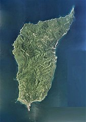
日本語: 奥尻島(北海道奥尻郡奥尻町)の空中写真。CHO20173X-C1-3から同7とCHO20173X-C2-3から同13とCHO20173X-C3-2から同14とCHO20173X-C4-2から同14とCHO20173X-C5-2から同12の合計53枚を合成作成。
English: Okushiri Island Aerial photograph.2017 |
| Date | |
| Source | 国土情報ウェブマッピングシステム |
| Auteur | 国土地理院 |
Conditions d’utilisation
[modifier]

|
Le détenteur des droits d’auteur de ce fichier, Ministère du Territoire, des Infrastructures, des Transports et du Tourisme, autorise n’importe qui à l’utiliser pour n’importe quelle utilisation, pourvu que le détenteur des droits d’auteur soit correctement attribué. La redistribution, les œuvres dérivées, l’utilisation commerciale et toutes les autres utilisations sont autorisées. |
Attribution:
Copyright © National Land Image Information (Color Aerial Photographs), Ministry of Land, Infrastructure, Transport and Tourism
|
 |
This image is copyrighted by the Ministry of Land, Infrastructure, Transport and Tourism of Japan. For terms of use, see the stipulation to use of National Land Information (in Japanese) and message from MLIT (in Japanese and English). When you display this image on an article, include the following phrase in the description: "Made based on National Land Image Information (Color Aerial Photographs), Ministry of Land, Infrastructure, Transport and Tourism".
|
Historique du fichier
Cliquer sur une date et heure pour voir le fichier tel qu'il était à ce moment-là.
| Date et heure | Vignette | Dimensions | Utilisateur | Commentaire | |
|---|---|---|---|---|---|
| actuel | 26 décembre 2020 à 02:38 | | 10 000 × 14 166 (25,11 Mio) | さかおり (d | contributions) | Uploaded a work by 国土地理院 from 国土情報ウェブマッピングシステム with UploadWizard |
Vous ne pouvez pas remplacer ce fichier.
Utilisations locales du fichier
Aucune page n’utilise ce fichier.
Utilisations du fichier sur d’autres wikis
Les autres wikis suivants utilisent ce fichier :
- Utilisation sur de.wikipedia.org
- Utilisation sur en.wikipedia.org
- Utilisation sur fr.wikipedia.org
- Utilisation sur ja.wikipedia.org
- Utilisation sur sv.wikipedia.org
- Utilisation sur uz.wikipedia.org