File:Operation Auca Map es.svg
Jump to navigation
Jump to search

Size of this PNG preview of this SVG file: 454 × 599 pixels. Other resolutions: 182 × 240 pixels | 364 × 480 pixels | 582 × 768 pixels | 776 × 1,024 pixels | 1,553 × 2,048 pixels | 878 × 1,158 pixels.
Original file (SVG file, nominally 878 × 1,158 pixels, file size: 43 KB)
Captions
Captions
Add a one-line explanation of what this file represents
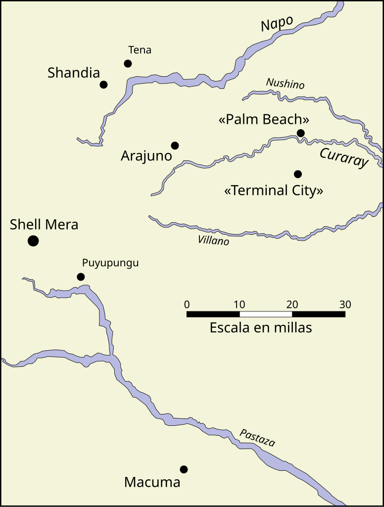
| Description | Map of the area where Operation Auca took place, in Ecuador. |
| Date | (UTC) |
| Source | |
| Author |
|
| This is a retouched picture, which means that it has been digitally altered from its original version. Modifications: Translation to spanish. The original can be viewed here: Operation Auca Map.svg:
|
I, the copyright holder of this work, hereby publish it under the following license:
This file is licensed under the Creative Commons Attribution-Share Alike 3.0 Unported, 2.5 Generic, 2.0 Generic and 1.0 Generic license.
- You are free:
- to share – to copy, distribute and transmit the work
- to remix – to adapt the work
- Under the following conditions:
- attribution – You must give appropriate credit, provide a link to the license, and indicate if changes were made. You may do so in any reasonable manner, but not in any way that suggests the licensor endorses you or your use.
- share alike – If you remix, transform, or build upon the material, you must distribute your contributions under the same or compatible license as the original.
Original upload log
[edit]
This image is a derivative work of the following images:
- File:Operation_Auca_Map.svg licensed with Cc-by-sa-3.0,2.5,2.0,1.0
- 2006-05-31T12:38:36Z Spangineer 878x1158 (44037 Bytes) {{Information |Description=Map of the area where [[:en:Operation Auca|Operation Auca]] took place. |Source=Own work, based on more detailed map by Harold K. Faye appearing in ''Through Gates of Splendor'' by Elisabeth Elliot
Uploaded with derivativeFX
File history
Click on a date/time to view the file as it appeared at that time.
| Date/Time | Thumbnail | Dimensions | User | Comment | |
|---|---|---|---|---|---|
| current | 10:08, 1 April 2010 | | 878 × 1,158 (43 KB) | Lucien leGrey (talk | contribs) | {{Information |Description=Map of the area where Operation Auca took place, in Ecuador. |Source=*File:Operation_Auca_Map.svg |Date=2010-04-01 10:06 (UTC) |Author=*File:Operation_Auca_Map.svg: Nathaniel C. Sheetz *der |
You cannot overwrite this file.
File usage on Commons
There are no pages that use this file.
File usage on other wikis
The following other wikis use this file:
- Usage on ca.wikipedia.org
- Usage on es.wikipedia.org