File:Orissa State map.svg
跳转到导航
跳转到搜索

此SVG文件的PNG预览的大小:740 × 599像素。 其他分辨率:296 × 240像素 | 593 × 480像素 | 948 × 768像素 | 1,264 × 1,024像素 | 2,529 × 2,048像素 | 2,184 × 1,769像素。
原始文件 (SVG文件,尺寸为2,184 × 1,769像素,文件大小:1.77 MB)
说明
说明
添加一行文字以描述该文件所表现的内容
摘要
[编辑]| 标题 |
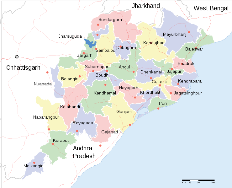
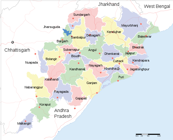
English: Locator map of Indian state, Odisha. |
| 描写 |
Locator map of the state of Orissa, India with district boundaries. |
| 日期 | |
| 来源 |
自己的作品 |
| 创作作者 | |
| 授权 (二次使用本文件) |
我,本作品著作权人,特此采用以下许可协议发表本作品: 本文件采用知识共享署名-相同方式共享 3.0 未本地化版本许可协议授权。
|
| Geotemporal data | |
| 描绘日期 | 20世纪下半期和21世纪 |
| 地理参考 | 如果不适当,请设置 warp_status = skip 为隐藏。 |
| Archival data | |
| 备注 | Part of WikiProject India Maps |
| 其他版本 |
[]
|


文件历史
点击某个日期/时间查看对应时刻的文件。
| 日期/时间 | 缩略图 | 大小 | 用户 | 备注 | |
|---|---|---|---|---|---|
| 当前 | 2020年6月10日 (三) 20:18 | | 2,184 × 1,769(1.77 MB) | শরদিন্দু ভট্টাচার্য্য(留言 | 贡献) | File uploaded using svgtranslate tool (https://svgtranslate.toolforge.org/). Added translation for bn. |
| 2011年4月1日 (五) 09:35 |  | 2,184 × 1,769(1.76 MB) | Jayantanth(留言 | 贡献) | == {{int:filedesc}} == {{WikiProject_India_Maps |Title=Orissa locator map |Description=Locator map of the state of Orissa, India with district boundaries. |Source= |Date=2008-12-29 |Author={{User:PlaneMad/Info}} }} [[Category:WikiPr |
您不可以覆盖此文件。
文件用途
以下12个页面使用本文件:
- User:Magog the Ogre/Multilingual legend/2020 June 1-10
- File:Orissa State map-bn.svg
- File:Orissa State map-gu.svg
- File:Orissa State map-hi.svg
- File:Orissa State map-mr.svg
- File:Orissa State map-or.svg
- File:Orissa State map-pa.svg
- File:Orissa State map-sat.svg
- File:Orissa State map-te.svg
- File:Orissa State map.svg
- File:Orissa State map as.svg
- Template:Other versions/Orissa State map
全域文件用途
以下其他wiki使用此文件:
- ar.wikipedia.org上的用途
- bcl.wikipedia.org上的用途
- bn.wikipedia.org上的用途
- cv.wikipedia.org上的用途
- en.wikipedia.org上的用途
- fa.wikipedia.org上的用途
- fr.wikipedia.org上的用途
- ha.wikipedia.org上的用途
- hr.wikipedia.org上的用途
- hy.wikipedia.org上的用途
- it.wikipedia.org上的用途
- kn.wikipedia.org上的用途
- mai.wikipedia.org上的用途
- ml.wikipedia.org上的用途
- mn.wikipedia.org上的用途
- ne.wikipedia.org上的用途
- pa.wikipedia.org上的用途
- ru.wikipedia.org上的用途
- sa.wikipedia.org上的用途
- sd.wikipedia.org上的用途
- tg.wikipedia.org上的用途
- ur.wikipedia.org上的用途
- zh.wikipedia.org上的用途
查看此文件的更多全域用途。