File:Orleans Ottawa 1982.jpg
Jump to navigation
Jump to search

Size of this preview: 800 × 533 pixels. Other resolutions: 320 × 213 pixels | 640 × 427 pixels | 1,024 × 683 pixels | 1,280 × 853 pixels | 2,400 × 1,600 pixels.
Original file (2,400 × 1,600 pixels, file size: 2.44 MB, MIME type: image/jpeg)
Captions
Captions
Add a one-line explanation of what this file represents
Summary
[edit]
| Description |
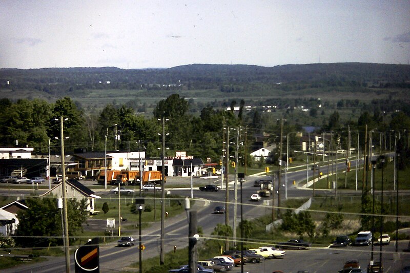
English: Showing the intersection of Champlain and Highway 17 (today Regional Road 174) as it existed on June 1, 1982, as viewed from the ridge of the Duford hill leading into Queenswood Heights. The southern portion of Champlain was removed in the late 1980's to make way for a massive expansion of the Place D'Orleans Shopping Centre (and the houses on the west side expropriated) up to St. Joseph in the 1988-1990 expansion. The area northwest (upper right) of the intersection is now the OC Transpo Park & Ride, the area to the southwest (lower right) would now be the Place D'Orleans OC Transpo transit station taking into account some realignment during the construction process. |
| Date | |
| Source |
Champlain & Highway 17 (June 1, 1982)
|
| Author | The Webhamster from Ottawa, Canada |
| Camera location | | View this and other nearby images on: OpenStreetMap |
|---|
Licensing
[edit]
This file is licensed under the Creative Commons Attribution-Share Alike 2.0 Generic license.
- You are free:
- to share – to copy, distribute and transmit the work
- to remix – to adapt the work
- Under the following conditions:
- attribution – You must give appropriate credit, provide a link to the license, and indicate if changes were made. You may do so in any reasonable manner, but not in any way that suggests the licensor endorses you or your use.
- share alike – If you remix, transform, or build upon the material, you must distribute your contributions under the same or compatible license as the original.
| This image, originally posted to Flickr, was reviewed on January 10, 2011 by the administrator or reviewer File Upload Bot (Magnus Manske), who confirmed that it was available on Flickr under the stated license on that date. |
File history
Click on a date/time to view the file as it appeared at that time.
| Date/Time | Thumbnail | Dimensions | User | Comment | |
|---|---|---|---|---|---|
| current | 01:13, 10 January 2011 | | 2,400 × 1,600 (2.44 MB) | File Upload Bot (Magnus Manske) (talk | contribs) | {{Information |Description=Showing the intersection of Champlain and Highway 17 (today Regional Road 174). Place D'Orleans was expanded across Champlain's extension (and the houses on the west side expropriated) up to St. Joseph in the 1988-1990 expansio |
You cannot overwrite this file.
File usage on Commons
The following 2 pages use this file:
File usage on other wikis
The following other wikis use this file:
- Usage on en.wikipedia.org