File:Ortelius - Maris Pacifici 1589.jpg
跳至導覽
跳至搜尋

預覽大小:800 × 554 像素。 其他解析度:320 × 222 像素 | 640 × 443 像素 | 1,024 × 709 像素 | 1,280 × 886 像素 | 2,560 × 1,773 像素 | 4,001 × 2,771 像素。
原始檔案 (4,001 × 2,771 像素,檔案大小:3.81 MB,MIME 類型:image/jpeg)
說明
說明
添加單行說明來描述出檔案所代表的內容
|
摘要
[編輯]| 描述 |
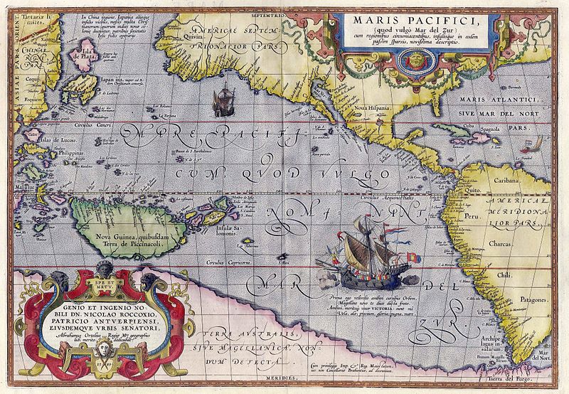
English: Maris Pacifici by Abraham Ortelius. This map was published in 1589 in his Theatrum Orbis Terrarum. It was not only the first printed map of the Pacific, but it also showed the Americas for the first time. Español: Maris Pacifici de Abraham Ortelius. Este mapa fue publicado en 1589 en su Theatrum Orbis Terrarum. No solo fue el primer mapa impreso del Pacífico, sino que también mostró las Américas por primera vez. Bajo la ilustración de la nao Victoria cruzando el Pacífico puede leer lo siguiente en latín: «Prima ego velivovis ambivi cursibus Orbem, Magellane novo te duce ducta freto. Ambivi, meritoque vocor VICTORIA: sunt mî Vela, alæ; precium, gloria: pugna mare» (en español, «Fui la primera en navegar alrededor del mundo por medio de velas, y te llevé a ti, Magallanes, líder, primero a través del estrecho. Navegué alrededor del mundo, por lo tanto, justamente me llamo Victoria, mis velas eran mis alas, mi premio era la gloria, mi lucha era con el mar»). |
|||||
| 日期 | ||||||
| 來源 | Helmink Antique Maps | |||||
| 作者 | ||||||
| 授權許可 (重用此檔案) |
|
|||||
| 其他版本 |
|
|||||


檔案歷史
點選日期/時間以檢視該時間的檔案版本。
| 日期/時間 | 縮圖 | 尺寸 | 使用者 | 備註 | |
|---|---|---|---|---|---|
| 目前 | 2007年5月5日 (六) 15:50 | | 4,001 × 2,771(3.81 MB) | Jan Arkesteijn(留言 | 貢獻) | {{Information |Description=Maris Pacifici by Abraham Ortelius |Source=[http://www.helmink.com/Antique_Map_Ortelius_Pacific/ Helmink Antique Maps] |Date=1589 |Author=Abraham Ortelius }} This map was published in 1589 in his 'Theatrum Orbis Terrarum'. It w |
無法覆蓋此檔案。
檔案用途
下列4個頁面有用到此檔案:
全域檔案使用狀況
以下其他 wiki 使用了這個檔案:
- als.wikipedia.org 的使用狀況
- ar.wikipedia.org 的使用狀況
- azb.wikipedia.org 的使用狀況
- az.wikipedia.org 的使用狀況
- bcl.wikipedia.org 的使用狀況
- be.wikipedia.org 的使用狀況
- bn.wikipedia.org 的使用狀況
- bo.wikipedia.org 的使用狀況
- ca.wikipedia.org 的使用狀況
- ckb.wikipedia.org 的使用狀況
- da.wikipedia.org 的使用狀況
- de.wikipedia.org 的使用狀況
- en.wikipedia.org 的使用狀況
- Pacific Ocean
- Abraham Ortelius
- Theatrum Orbis Terrarum
- Portal:Maps/Selected picture
- Wikipedia:Featured pictures thumbs/11
- Wikipedia:Featured picture candidates/March-2008
- Wikipedia:Featured picture candidates/File:Ortelius - Maris Pacifici 1589.jpg
- Wikipedia:Wikipedia Signpost/2008-03-31/Features and admins
- Wikipedia:Featured pictures/Diagrams, drawings, and maps/Maps
- Maris Pacifici
- User talk:Paulcmnt/Archive 1
- Wikipedia:Wikipedia Signpost/2008-03-31/SPV
- Wikipedia:Picture of the day/October 2008
- Template:POTD/2008-10-23
- Portal:Maps/Selected picture/50
- Wikipedia:Graphics Lab/Photography workshop/Archive/Jul 2010
- Portal:Oceans
- Wikipedia:Contents/gallery2
- Wikipedia:Wikipedia Signpost/Single/2008-03-31
- es.wikipedia.org 的使用狀況
- fr.wikipedia.org 的使用狀況
- fr.wikiversity.org 的使用狀況
- fy.wikipedia.org 的使用狀況
- gcr.wikipedia.org 的使用狀況
- gl.wikipedia.org 的使用狀況
- he.wikipedia.org 的使用狀況
- hi.wikipedia.org 的使用狀況
- hu.wikipedia.org 的使用狀況
檢視此檔案的更多全域使用狀況。
詮釋資料
分類:
- 16th-century maps of the Pacific Ocean
- Theatrum Orbis Terrarum
- Maps by Abraham Ortelius
- Ships on maps
- 1580s maps of South America
- 16th-century maps of the Spanish Empire
- Victoria (ship, 1519)
- 1589 works in Europe
- 1589 maps
- Terra Australis
- 16th-century maps of Japan
- Old maps of New Guinea
- Old maps of Rica de Plata