File:Ortlergruppe (nach Moriggl 1924).png
Jump to navigation
Jump to search

Size of this preview: 800 × 584 pixels. Other resolutions: 320 × 234 pixels | 640 × 468 pixels | 1,024 × 748 pixels | 1,280 × 935 pixels | 1,447 × 1,057 pixels.
Original file (1,447 × 1,057 pixels, file size: 809 KB, MIME type: image/png)
Captions
Captions
Add a one-line explanation of what this file represents
Summary
[edit].png&action=edit§ion=1)
| Description |
|
|||||||||
| Date | ||||||||||
| Source |
Own work Map was created using:
|
|||||||||
| Creator | ||||||||||
| Permission (Reusing this file) |
Map data (c) OpenStreetMap (and) contributors, CC-BY-SA | |||||||||
| Geotemporal data | ||||||||||
| Bounding box |
|
|||||||||
| Georeferencing | ||||||||||
Licensing
[edit].png&action=edit§ion=2)
I, the copyright holder of this work, hereby publish it under the following license:
This file is licensed under the Creative Commons Attribution 3.0 Unported license.
- You are free:
- to share – to copy, distribute and transmit the work
- to remix – to adapt the work
- Under the following conditions:
- attribution – You must give appropriate credit, provide a link to the license, and indicate if changes were made. You may do so in any reasonable manner, but not in any way that suggests the licensor endorses you or your use.
| This work is licensed under the Open Database License (summary). |
File history
Click on a date/time to view the file as it appeared at that time.
| Date/Time | Thumbnail | Dimensions | User | Comment | |
|---|---|---|---|---|---|
| current | 18:50, 28 November 2016 | | 1,447 × 1,057 (809 KB) | Pechristener (talk | contribs) | Karte richtig gestellt (Nonsberger Alpen abgetrennt) |
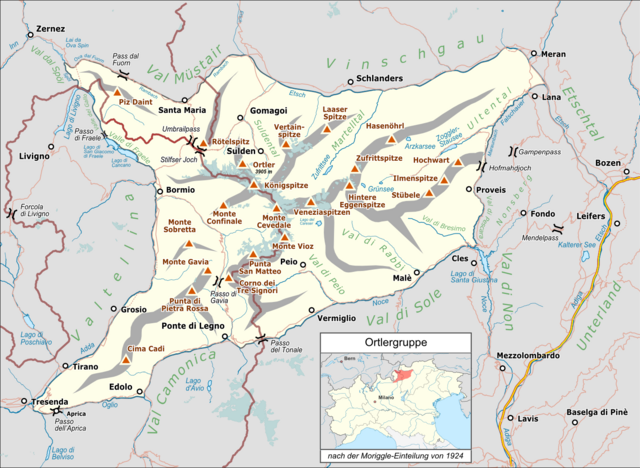
| 13:23, 27 November 2016 |  | 1,447 × 1,057 (758 KB) | Pechristener (talk | contribs) | {{Map |Description={{de|1=Lagekarte der {{w|Ortlergruppe||de}} nach der Einteilung von {{w|Josef Moriggl||de}} von 1924}} |Source ={{own}} Map was created using: *[http://www.openstreetmap.org/ Open Street Map] *[[:File:Italy_North_location... |
You cannot overwrite this file.
File usage on Commons
The following page uses this file:
File usage on other wikis
The following other wikis use this file:
- Usage on als.wikipedia.org
- Usage on de.wikipedia.org
- Usage on nl.wikipedia.org
.png&oldid=711744125)