File:Ossetia rus.png
Jump to navigation
Jump to search

Size of this preview: 391 × 599 pixels. Other resolutions: 156 × 240 pixels | 313 × 480 pixels | 696 × 1,067 pixels.
Original file (696 × 1,067 pixels, file size: 44 KB, MIME type: image/png)
Captions
Captions
Add a one-line explanation of what this file represents
Any autoconfirmed user can overwrite this file from the same source. Please ensure that overwrites comply with the guideline.
Summary
[edit]
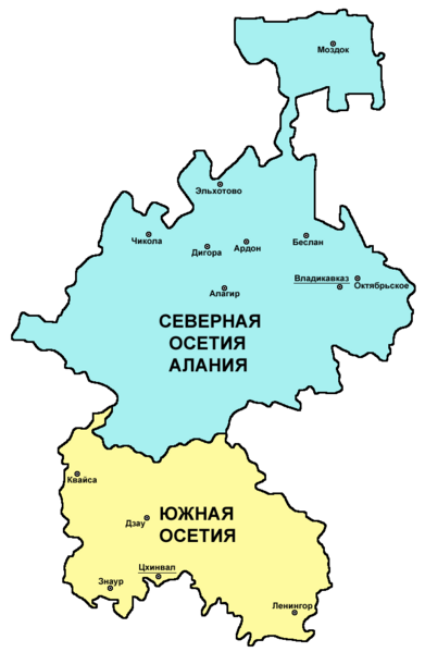
| Description | Map of Ossetia (North Ossetia and South Ossetia) - Russian language version. |
| Date | 28 December 2007 (original upload date) |
| Source | Own work |
| Author | PANONIAN and Chesnok |
Licensing
[edit]
self made map - Russian language version of this file: http://commons.wikimedia.org/wiki/File:Ossetia01.png (author of that file is User:PANONIAN).
| I, the copyright holder of this work, release this work into the public domain. This applies worldwide. In some countries this may not be legally possible; if so: I grant anyone the right to use this work for any purpose, without any conditions, unless such conditions are required by law. |

|
This map has been uploaded by Electionworld from en.wikipedia.org to enable the |
References
[edit]
Borders and locations of major settlements:
- http://iratta.com/uploads/posts/atlas/21/karta.jpg
- http://foto.mail.ru/bk/lyks2003/150/163.html
- http://4.bp.blogspot.com/_PB5-El7se4s/SJzcr3lGyAI/AAAAAAAAISU/kagljy4-1b0/s400/ossetia+map.jpg
- http://static.guim.co.uk/sys-images/Guardian/Pix/pictures/2008/8/8/1218195196317/ossetia220.jpg
- http://www.pri.org/theworld/files/images/ossetia_map.jpg
List of larger settlements:
File history
Click on a date/time to view the file as it appeared at that time.
| Date/Time | Thumbnail | Dimensions | User | Comment | |
|---|---|---|---|---|---|
| current | 06:02, 10 May 2024 | | 696 × 1,067 (44 KB) | Egor (talk | contribs) | Fixed bug: part of Vladikavkaz (Zavodkoy) is not a separate village and is located in a different location |
| 10:24, 6 March 2011 |  | 696 × 1,067 (50 KB) | WikiEditor2004 (talk | contribs) | improved version | |
| 07:16, 28 December 2007 |  | 453 × 674 (8 KB) | Chesnok (talk | contribs) | {{ew|en|PANONIAN}} map of Ossetia (self made) {{PD-self}} Category:Ossetia Category:Maps of the Russian republics Category:Maps of Georgia |
You cannot overwrite this file.
File usage on Commons
The following page uses this file:
File usage on other wikis
The following other wikis use this file:
- Usage on ja.wikipedia.org
- Usage on krc.wikipedia.org
- Usage on ru.wikipedia.org
- Usage on sk.wikipedia.org
- Usage on uk.wikipedia.org
- Usage on zh.wikipedia.org