File:Ostfront 18021915.jpg
ナビゲーションに移動
検索に移動
このプレビューのサイズ: 775 × 600 ピクセル。 その他の解像度: 310 × 240 ピクセル | 620 × 480 ピクセル | 993 × 768 ピクセル | 1,242 × 961 ピクセル。
元のファイル (1,242 × 961 ピクセル、ファイルサイズ: 201キロバイト、MIME タイプ: image/jpeg)
キャプション
キャプション
このファイルの内容を1行で記述してください
概要
[編集]
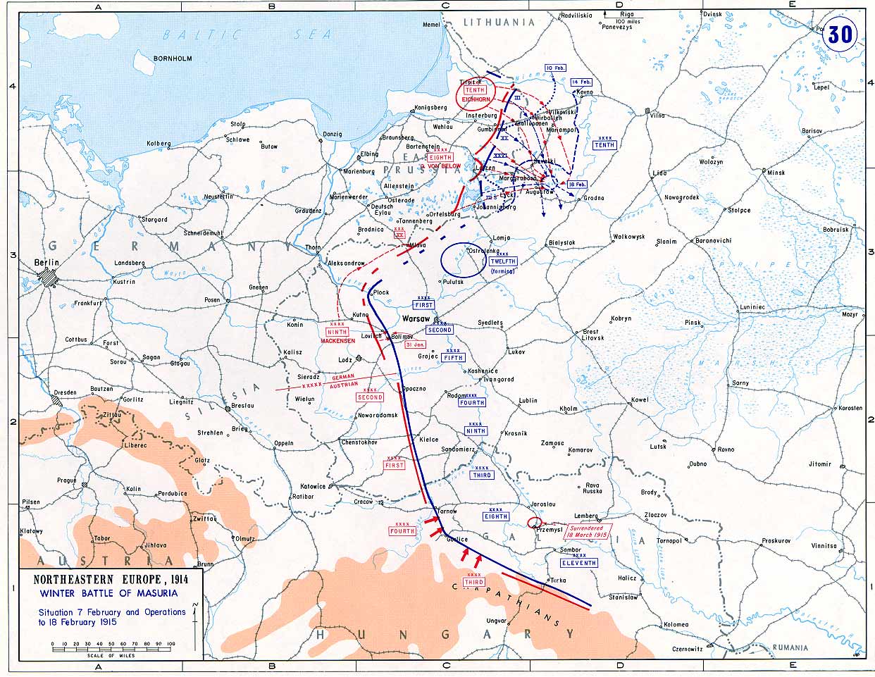
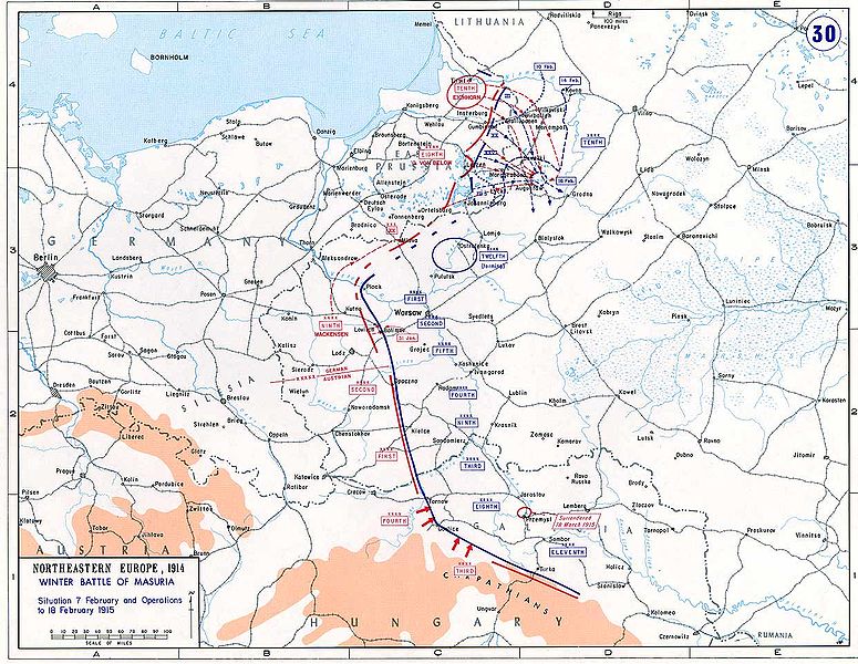
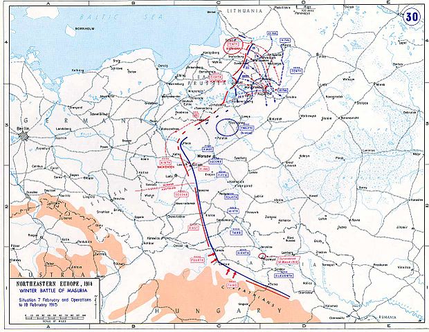
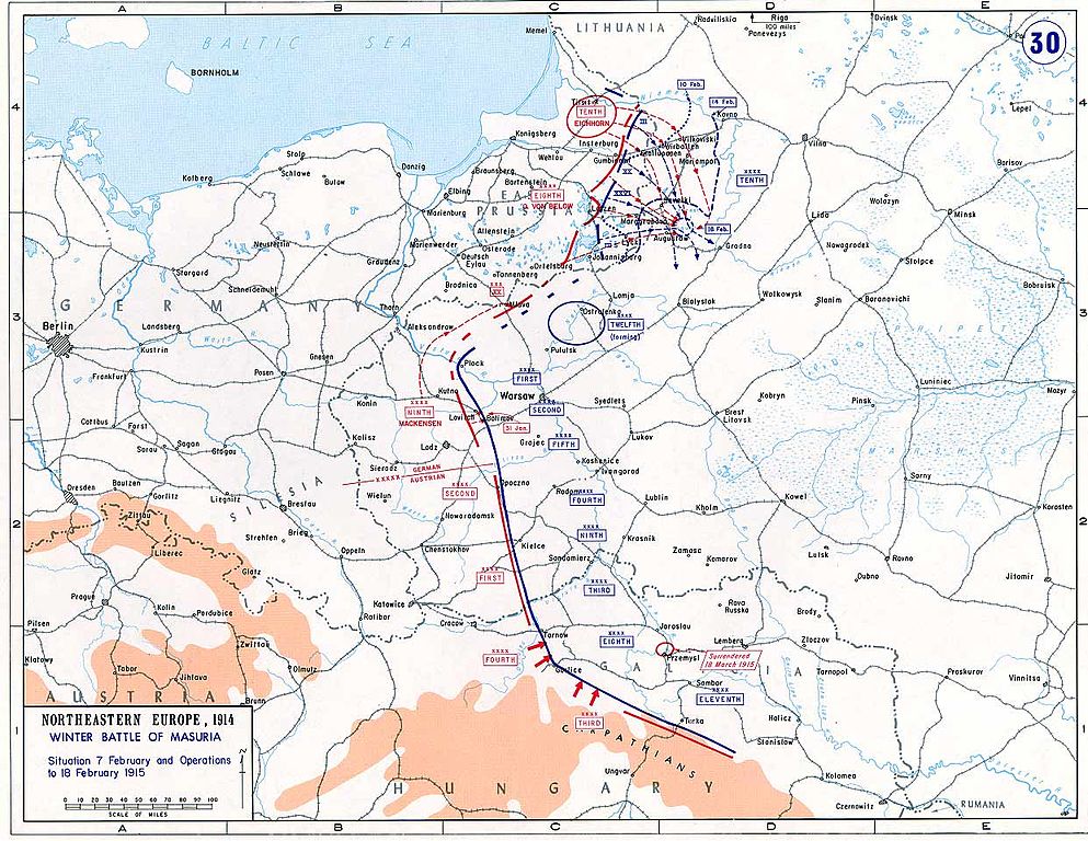
| 解説 | Eastern Front, February 7-18, 1915 |
| 原典 | http://www.dean.usma.edu/history/web03/atlases/great%20war/great%20war%20%20pages/great%20war%20map%2030.htm (archive) |
| 作者 | Department of Military Art and Engineering, at the U.S. Military Academy (West Point) |
Taken from the campaign series, made public by the US-Army under www.dean.usma.edu
The picture is public domain. It shows the battle of Tannenberg in its last phase
- Source: dean.usma.edu アーカイブされたコピー at the Wayback Machine
From website:
- In 1938 the predecessors of what is today The Department of History at the United States Military Academy began developing a series of campaign atlases to aid in teaching cadets a course entitled, "History of the Military Art." Since then, the Department has produced over six atlases and more than one thousand maps, encompassing not only America’s wars but global conflicts as well.
- In keeping abreast with today's technology, the Department of History is providing these maps on the internet as part of the department's outreach program. The maps were created by the United States Military Academy’s Department of History and are the digital versions from the atlases printed by the United States Defense Printing Agency. We gratefully acknowledge the accomplishments of the department's former cartographer, Mr. Edward J. Krasnoborski, along with the works of our present cartographer, Mr. Frank Martini.
- Please be aware that these maps are large in file size and may require substantial download times.
ライセンス
[編集]
|
|
 |
ファイルの履歴
過去の版のファイルを表示するには、その版の日時をクリックしてください。
| 日付と時刻 | サムネイル | 寸法 | 利用者 | コメント | |
|---|---|---|---|---|---|
| 現在の版 | 2005年10月1日 (土) 15:42 | | 1,242 × 961 (201キロバイト) | Nasiruddin (トーク | 投稿記録) | Taken from the campaign series, made public by the US-Army under www.dean.usma.edu The picture is public domain. It shows the battle of Tannenberg in its last phase *Source: [http://www.dean.usma.edu/history/web03/atlases/great%20war/great%20war%20index. |
このファイルは上書きできません。
ファイルの使用状況
以下の 3 ページがこのファイルを使用しています:
グローバルなファイル使用状況
以下に挙げる他のウィキがこの画像を使っています:
- ast.wikipedia.org での使用状況
- azb.wikipedia.org での使用状況
- ba.wikipedia.org での使用状況
- be-tarask.wikipedia.org での使用状況
- be.wikipedia.org での使用状況
- cs.wikipedia.org での使用状況
- de.wikipedia.org での使用状況
- en.wikipedia.org での使用状況
- Second Battle of the Masurian Lakes
- Battle of Humin-Bolimów
- 20th Army Corps (Russian Empire)
- Wikipedia:WikiProject Military history/News/February 2015/World War I timeline
- Wikipedia:Graphics Lab/Map workshop/Archive/Dec 2015
- Suwałki Gap
- Battle of Łomża
- Second Battle of the Vistula River
- Easter battle at Kalvarija
- User:Falcaorib/Russia and Soviet Union
- fa.wikipedia.org での使用状況
- fr.wikipedia.org での使用状況
- gl.wikipedia.org での使用状況
- he.wikipedia.org での使用状況
- hr.wikipedia.org での使用状況
- hu.wikipedia.org での使用状況
- id.wikipedia.org での使用状況
- it.wikipedia.org での使用状況
- ja.wikipedia.org での使用状況
- krc.wikipedia.org での使用状況
- lv.wikipedia.org での使用状況
- mk.wikipedia.org での使用状況
- nl.wikipedia.org での使用状況
- pl.wikipedia.org での使用状況
- ro.wikipedia.org での使用状況
- ru.wikipedia.org での使用状況
- sr.wikipedia.org での使用状況
このファイルのグローバル使用状況を表示する。