File:Oude kaart - 's-Gravenhage - 20084747 - RCE.jpg
Jump to navigation
Jump to search

Size of this preview: 428 × 599 pixels. Other resolutions: 171 × 240 pixels | 343 × 480 pixels | 857 × 1,200 pixels.
Original file (857 × 1,200 pixels, file size: 369 KB, MIME type: image/jpeg)
Captions
Captions
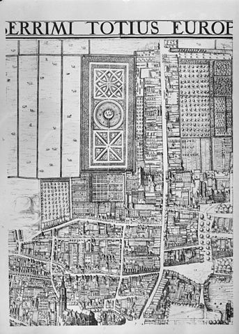
Part of map (anno 1616) of The Hague
Summary
[edit]
| Description |
Nederlands: Plattegronden en overzichten: oude kaart. Detail van een grotere kaart.
| ||
| Address |
|
||
| Date | |||
| Source | Rijksdienst voor het Cultureel Erfgoed | ||
| Author | Cornelis Bos, Jurifaes Jacobsz van Harn | ||
| Other versions |
.jpg) |
Licensing
[edit]
| This file was uploaded as part of the RCE upload which was limited to up to a 1200px size. The original files have been made available. This file should be replaced by the higher resolution file. This will be done by a robot. |
| This file was provided to Wikimedia Commons by the Rijksdienst voor het Cultureel Erfgoed as part of an image release. The Rijksdienst voor Cultureel Erfgoed, exclusively provides images that are either made by its own employees, or that are otherwise free of copyright. (rights) |
This file is licensed under the Creative Commons Attribution-Share Alike 4.0 International license.
Attribution: Rijksdienst voor het Cultureel Erfgoed
- You are free:
- to share – to copy, distribute and transmit the work
- to remix – to adapt the work
- Under the following conditions:
- attribution – You must give appropriate credit, provide a link to the license, and indicate if changes were made. You may do so in any reasonable manner, but not in any way that suggests the licensor endorses you or your use.
- share alike – If you remix, transform, or build upon the material, you must distribute your contributions under the same or compatible license as the original.
File history
Click on a date/time to view the file as it appeared at that time.
| Date/Time | Thumbnail | Dimensions | User | Comment | |
|---|---|---|---|---|---|
| current | 14:47, 2 January 2013 | | 857 × 1,200 (369 KB) | BotMultichillT (talk | contribs) | {{subst:RCE data ingestion layout|subst=subst: |@attributes_created=2009-05-18T23:39:00 |@attributes_modification=2012-10-25T13:14:53 |@attributes_priref=20084747 |@attributes_selected=False |Alternative_number_alternative_number=8599 |Alternative_numb... |
You cannot overwrite this file.
File usage on Commons
There are no pages that use this file.
File usage on other wikis
The following other wikis use this file:
- Usage on nl.wikipedia.org