File:Oudegracht 133.jpg
Jump to navigation
Jump to search

Size of this preview: 450 × 600 pixels. Other resolutions: 180 × 240 pixels | 360 × 480 pixels | 576 × 768 pixels | 768 × 1,024 pixels | 2,112 × 2,816 pixels.
Original file (2,112 × 2,816 pixels, file size: 2.81 MB, MIME type: image/jpeg)
Captions
Captions
Add a one-line explanation of what this file represents
Summary
[edit]
| Description |
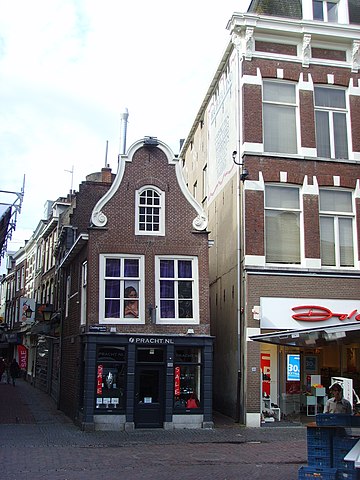
Nederlands: Grachtenpand Oudegracht 133 in Utrecht, klaarblijkelijk gebouwd zonder gebruik te hebben gemaakt van een waterpas. Foto gemaakt vanaf de Bakkerbrug. Deels ook zichtbaar ingang naar de Hamsteeg.
|
||
| Date | |||
| Source | Own work | ||
| Author | Luctor |
| Camera location | | View this and other nearby images on: OpenStreetMap |
|---|
Licensing
[edit]
| I, the copyright holder of this work, release this work into the public domain. This applies worldwide. In some countries this may not be legally possible; if so: I grant anyone the right to use this work for any purpose, without any conditions, unless such conditions are required by law. |
File history
Click on a date/time to view the file as it appeared at that time.
| Date/Time | Thumbnail | Dimensions | User | Comment | |
|---|---|---|---|---|---|
| current | 14:00, 23 July 2008 | | 2,112 × 2,816 (2.81 MB) | Luctor (talk | contribs) | {{Information |Description={{nl|Grachtenpand '''Oudegracht 133''' in Utrecht, klaarblijkelijk gebouwd zonder gebruik te hebben gemaakt van een waterpas. Foto gemaakt vanaf de Bakkerbrug}} {{location dms|52|5|30.17640356703737|N|5|7|1.64 |
You cannot overwrite this file.
File usage on Commons
The following page uses this file:
File usage on other wikis
The following other wikis use this file:
- Usage on nl.wikipedia.org
- Usage on www.wikidata.org