File:Outre-mer en sans Terre Adelie.png
跳至導覽
跳至搜尋
預覽大小:800 × 342 像素。 其他解析度:320 × 137 像素 | 640 × 273 像素 | 1,456 × 622 像素。
原始檔案 (1,456 × 622 像素,檔案大小:49 KB,MIME 類型:image/png)
說明
說明
添加單行說明來描述出檔案所代表的內容
摘要
[編輯]

|
本圖片是以PNG、GIF或JPEG格式上傳。然而,其中包含的資料或訊息,應該重新建立成可縮放向量圖形(SVG)檔案,以更有效率或更準確的方式儲存。如有可能,請上傳本圖片的SVG格式版本。在上傳之後,請修改維基各姊妹計畫中所有使用舊版圖片的條目(列在圖像連結章節中),替換為新版圖片,並在舊圖片的描述頁中加入{{Vector version available|新圖片名稱.svg}}模板,同時移除本模板。
|
| 描述 |
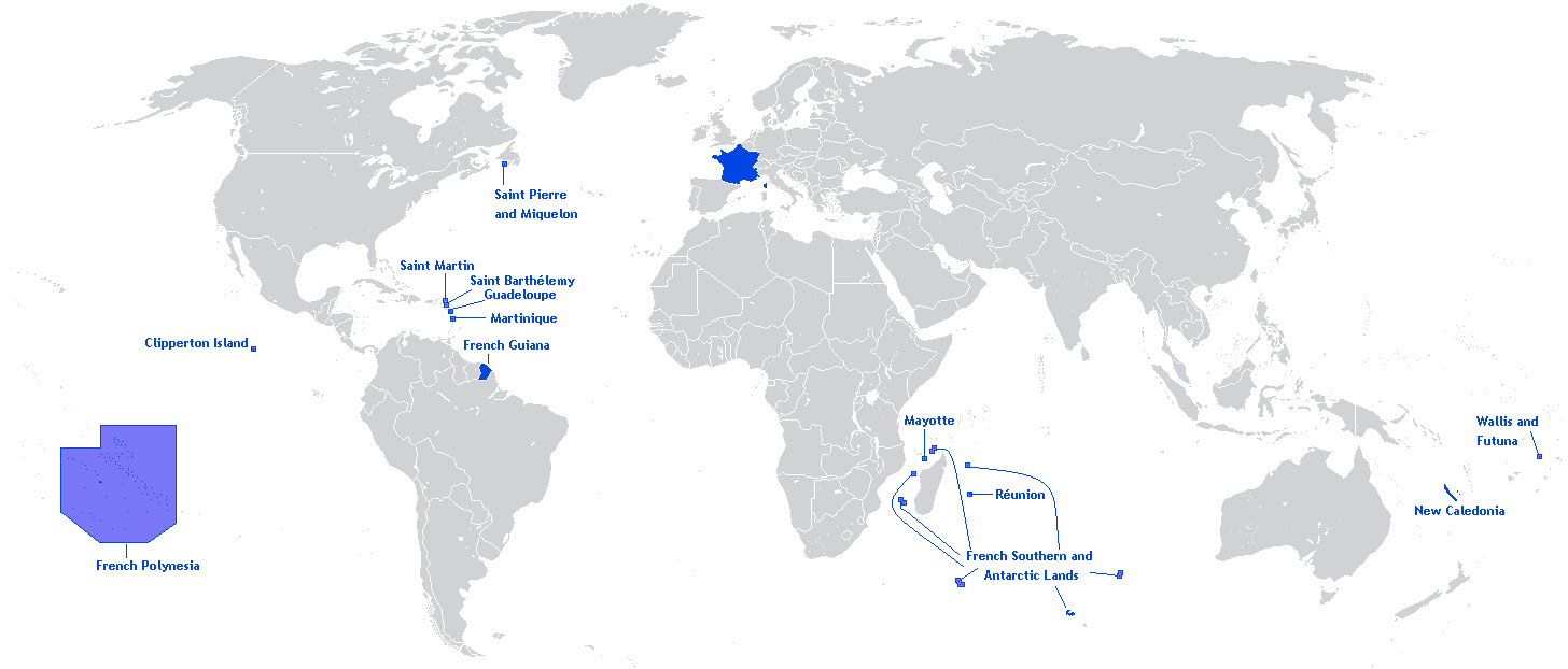
English: A map showing the Overseas departments and territories of France, excluding the territory of Adélie Land in Antarctica, where sovereignty is suspended |
| 日期 | |
| 來源 | 自己的作品 |
| 作者 | Originally Hoshie |
| 其他版本 | Adapted from File:Outre-mer en.png |
English: This image is a cropped version of Image:Outre-mer en.png initally created by user Hoshie. Antarctica was cropped.
授權條款
[編輯]
Hoshie,此作品的版權所有人,決定用以下授權條款發佈本作品:

|
已授權您依據自由軟體基金會發行的無固定段落、封面文字和封底文字GNU自由文件授權條款1.2版或任意後續版本,對本檔進行複製、傳播和/或修改。該協議的副本列在GNU自由文件授權條款中。 |
| 此檔案採用創用CC 姓名標示-相同方式分享 3.0 未在地化版本授權條款。 | ||
| 姓名標示: Hoshie | ||
| ||
| 已新增授權條款標題至此檔案,作為GFDL授權更新的一部份。 |
檔案歷史
點選日期/時間以檢視該時間的檔案版本。
| 日期/時間 | 縮圖 | 尺寸 | 使用者 | 備註 | |
|---|---|---|---|---|---|
| 目前 | 2018年3月27日 (二) 20:26 | | 1,456 × 622(49 KB) | Maphobbyist(留言 | 貢獻) | Upload |
| 2012年5月27日 (日) 12:01 |  | 1,456 × 622(59 KB) | Hazhk(留言 | 貢獻) | Changing color | |
| 2012年2月12日 (日) 20:47 |  | 1,480 × 625(68 KB) | Spesh531(留言 | 貢獻) | same as File:Outre-mer en.png, without Antarctica | |
| 2010年10月21日 (四) 00:35 |  | 1,431 × 655(54 KB) | Rosss(留言 | 貢獻) | Better view of French Polynesia | |
| 2009年11月25日 (三) 21:23 |  | 1,431 × 655(30 KB) | The Illusional Ministry(留言 | 貢獻) | removed borer from french polynesia | |
| 2009年11月25日 (三) 21:22 |  | 1,431 × 655(30 KB) | The Illusional Ministry(留言 | 貢獻) | ||
| 2007年12月17日 (一) 03:31 |  | 1,431 × 655(35 KB) | Rosss(留言 | 貢獻) | Wider margin | |
| 2007年12月17日 (一) 03:26 |  | 1,431 × 639(35 KB) | Rosss(留言 | 貢獻) | This image is a cropped version of Image:Outre-mer en.png initally created by user Hoshie. Antartica was cropped. ==License== {{GFDL-user|Hoshie}} Category:World maps of Overseas France |
無法覆蓋此檔案。
檔案用途
下列3個頁面有用到此檔案:
全域檔案使用狀況
以下其他 wiki 使用了這個檔案:
- an.wikipedia.org 的使用狀況
- awa.wikipedia.org 的使用狀況
- bn.wikibooks.org 的使用狀況
- ckb.wikipedia.org 的使用狀況
- da.wikipedia.org 的使用狀況
- dv.wikipedia.org 的使用狀況
- en.wikipedia.org 的使用狀況
- Regions of France
- Outline of France
- Wikipedia:Graphics Lab/Map workshop/Archive/Dec 2009
- Wikipedia:Graphics Lab/Map workshop/Archive/Jun 2012
- User:SkulkingMEDIA
- User:Andreapr94/sandbox/Infobox/Country
- User:Jonperez91/sandbox/Infoboxes/Country
- User:Ane San José/sandbox/Infobox/Country
- User:P.aurrecoechea/Sandbox/Infobox/Country
- User:Trizia9/sandbox/Infobox/Country
- User:Ibonarzua/sandbox/Infobox/Country
- User:Mikel M/sandbox/Infobox/Country
- en.wikibooks.org 的使用狀況
- es.wikipedia.org 的使用狀況
- et.wikipedia.org 的使用狀況
- eu.wikipedia.org 的使用狀況
- fa.wikipedia.org 的使用狀況
- fr.wikipedia.org 的使用狀況
- hi.wikipedia.org 的使用狀況
- hy.wikipedia.org 的使用狀況
- id.wikipedia.org 的使用狀況
- id.wikibooks.org 的使用狀況
- ilo.wikipedia.org 的使用狀況
- ja.wikipedia.org 的使用狀況
- lv.wikipedia.org 的使用狀況
- mai.wikipedia.org 的使用狀況
- min.wikipedia.org 的使用狀況
- ml.wikipedia.org 的使用狀況
- mzn.wikipedia.org 的使用狀況
- ne.wikipedia.org 的使用狀況
- nl.wikipedia.org 的使用狀況
- no.wikipedia.org 的使用狀況
- pa.wikipedia.org 的使用狀況
- pcd.wikipedia.org 的使用狀況
- pdc.wikipedia.org 的使用狀況
- pt.wikipedia.org 的使用狀況
- sah.wikipedia.org 的使用狀況
- sh.wikipedia.org 的使用狀況
檢視此檔案的更多全域使用狀況。