File:Overlay port and canals 1565 map Antverpia (Atlas van Loon).svg
Jump to navigation
Jump to search

Size of this PNG preview of this SVG file: 754 × 599 pixels. Other resolutions: 302 × 240 pixels | 604 × 480 pixels | 966 × 768 pixels | 1,280 × 1,018 pixels | 2,560 × 2,035 pixels | 5,500 × 4,373 pixels.
Original file (SVG file, nominally 5,500 × 4,373 pixels, file size: 5.83 MB)
Captions
Captions
Add a one-line explanation of what this file represents
Summary
[edit].svg&action=edit§ion=1)
| Description |
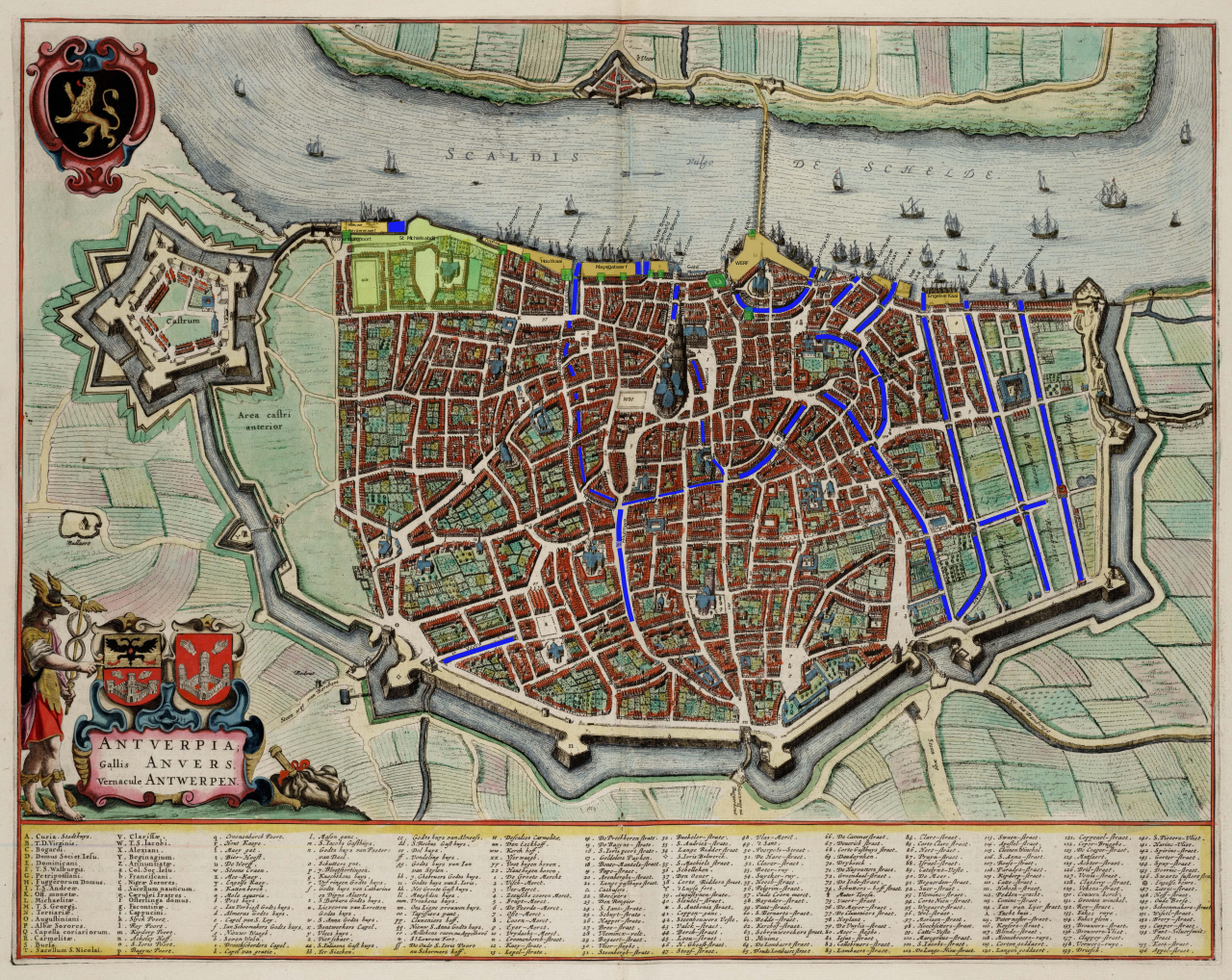
English: Antwerp 1565 port and canals overlaid on the map Antverpia; Gallis Anvers, Vernacule Antwerpen (Atlas van Loon) in the image, and based on the map Schets van de Antwerpse haven omstreeks 1656 by W. De Schampelaere [1]
Français : Anvers 1565 les canaux et port d'Anvers superimposé sur la carte Antverpia; Gallis Anvers, Vernacule Antwerpen (Atlas van Loon) , annoté, et basé sur la carte Schets van de Antwerpse haven omstreeks 1656 by W. De Schampelaere [2]
Nederlands: Antwerpse ruien. vlieten en vesten haven anno 1565 geannotateerde overlay op de kaart Antverpia; Gallis Anvers, Vernacule Antwerpen (Atlas van Loon), en gebaseerd op de kaart Schets van de Antwerpse haven omstreeks 1656 by W. De Schampelaere [3]
.svg) |
| Date | |
| Source | Own work |
| Author | DerekvG |
Licensing
[edit].svg&action=edit§ion=2)
I, the copyright holder of this work, hereby publish it under the following license:
This file is licensed under the Creative Commons Attribution-Share Alike 4.0 International license.
- You are free:
- to share – to copy, distribute and transmit the work
- to remix – to adapt the work
- Under the following conditions:
- attribution – You must give appropriate credit, provide a link to the license, and indicate if changes were made. You may do so in any reasonable manner, but not in any way that suggests the licensor endorses you or your use.
- share alike – If you remix, transform, or build upon the material, you must distribute your contributions under the same or compatible license as the original.
- ↑ (in dutch) (1978) De Stad Antwerpen van de romeinse tijd tot de 17de eeuw , Topografische studie rond het plan van Virgilius Bononiensis 1565, City of Brussels: Gemeentekrediet/Cŕedit Communal, pp. 116 OCLC: 901833377.
- ↑ (in dutch) (1978) De Stad Antwerpen van de romeinse tijd tot de 17de eeuw , Topografische studie rond het plan van Virgilius Bononiensis 1565, City of Brussels: Gemeentekrediet/Cŕedit Communal, pp. 116 OCLC: 901833377.
- ↑ (in dutch) (1978) De Stad Antwerpen van de romeinse tijd tot de 17de eeuw , Topografische studie rond het plan van Virgilius Bononiensis 1565, City of Brussels: Gemeentekrediet/Cŕedit Communal, pp. 116 OCLC: 901833377.
File history
Click on a date/time to view the file as it appeared at that time.
| Date/Time | Thumbnail | Dimensions | User | Comment | |
|---|---|---|---|---|---|
| current | 15:53, 3 November 2016 | | 5,500 × 4,373 (5.83 MB) | DerekvG (talk | contribs) | User created page with UploadWizard |
You cannot overwrite this file.
File usage on Commons
There are no pages that use this file.
File usage on other wikis
The following other wikis use this file:
- Usage on en.wikipedia.org
.svg&oldid=426995049)