File:Overstrand LM topographic map.svg
Jump to navigation
Jump to search

Size of this PNG preview of this SVG file: 788 × 599 pixels. Other resolutions: 316 × 240 pixels | 631 × 480 pixels | 1,010 × 768 pixels | 1,280 × 974 pixels | 2,560 × 1,947 pixels | 1,262 × 960 pixels.
Original file (SVG file, nominally 1,262 × 960 pixels, file size: 1.85 MB)
Captions
Captions
Add a one-line explanation of what this file represents
Summary[edit]
| Description |
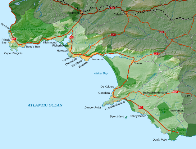
English: Topographic map of the Overstrand Local Municipality in South Africa. |
|||
| Date | ||||
| Source | Own work | |||
| Author | Htonl | |||
| Permission (Reusing this file) |
I, the copyright holder of this work, hereby publish it under the following licenses: This file is licensed under the Creative Commons Attribution-Share Alike 4.0 International license.
This file is licensed under the Creative Commons Attribution-Share Alike 3.0 Unported license.
You may select the license of your choice.
|
|||
| SVG development |
File history
Click on a date/time to view the file as it appeared at that time.
| Date/Time | Thumbnail | Dimensions | User | Comment | |
|---|---|---|---|---|---|
| current | 10:18, 27 December 2022 | | 1,262 × 960 (1.85 MB) | Htonl (talk | contribs) | == {{int:filedesc}} == {{Information |Description ={{en|1=Topographic map of the Overstrand Local Municipality in South Africa.}} |Source ={{own}} |Author =Htonl |Date =2022-12-27 |Permission ={{self|cc-by-sa-4.0,3.0}}{{ODbL OpenStreetMap}} |other_versions = |other fields = {{Igen|Inkscape|v|+|!=t|>|s=m}} }} Category:Maps of local municipalities of the Western Cape Category:Maps by Htonl |
You cannot overwrite this file.
File usage on Commons
The following page uses this file:
File usage on other wikis
The following other wikis use this file:
- Usage on de.wikipedia.org
- Usage on en.wikipedia.org