File:Overview Tuxtepec City.jpg
Jump to navigation
Jump to search

Size of this preview: 800 × 308 pixels. Other resolutions: 320 × 123 pixels | 640 × 247 pixels | 1,024 × 395 pixels | 1,280 × 493 pixels | 2,816 × 1,085 pixels.
Original file (2,816 × 1,085 pixels, file size: 2.26 MB, MIME type: image/jpeg)
Captions
Captions
Add a one-line explanation of what this file represents
Summary
[edit]
| Description |
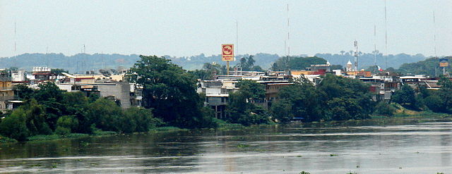
English: Overview of the city of Tuxtepec, seen from the bridge of the same name, which unites the boluevares Benito Juárez and conected the city of Oaxaca de Juarez and Loma Bonita.
Español: Panorámica de la ciudad de Tuxtepec, vista desde el puente del mismo nombre, que une a los boluevares Benito Juárez y que comunica a la ciudad con Oaxaca de Juárez y a Loma Bonita. |
| Date | |
| Source | Own work |
| Author | El Ágora |
| Camera location | | View this and other nearby images on: OpenStreetMap |
|---|
Licensing
[edit]
| I, the copyright holder of this work, release this work into the public domain. This applies worldwide. In some countries this may not be legally possible; if so: I grant anyone the right to use this work for any purpose, without any conditions, unless such conditions are required by law. |
File history
Click on a date/time to view the file as it appeared at that time.
| Date/Time | Thumbnail | Dimensions | User | Comment | |
|---|---|---|---|---|---|
| current | 00:00, 2 July 2008 | 2,816 × 1,085 (2.26 MB) | El Ágora (talk | contribs) | {{Information |Description={{en|1=Overview of the city of Tuxtepec, seen from the bridge of the same name, which unites the boluevares Benito Juárez and conected the city of Oaxaca de Juarez and Loma Bonita.}} {{es|1=Panorámica de la ciudad de Tuxtepec, |
You cannot overwrite this file.
File usage on Commons
There are no pages that use this file.
File usage on other wikis
The following other wikis use this file:
- Usage on lt.wikipedia.org