File:PérdidasTerritorialesRumanas1940.svg
跳至導覽
跳至搜尋

此 SVG 檔案的 PNG 預覽的大小:800 × 573 像素。 其他解析度:320 × 229 像素 | 640 × 458 像素 | 1,024 × 733 像素 | 1,280 × 917 像素 | 2,560 × 1,834 像素 | 1,036 × 742 像素。
原始檔案 (SVG 檔案,表面大小:1,036 × 742 像素,檔案大小:328 KB)
說明
說明
添加單行說明來描述出檔案所代表的內容
| 描述 |
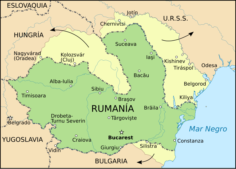
English: Romania Romania's territorial losses in the summer of 1940.
Español: Pérdidas territoriales de Rumanía en el verano de 1940. |
| 日期 | (UTC) |
| 來源 | |
| 作者 |
|
| 其他版本 |
[]
|


| 這是一張修飾過的圖片,即本圖片是用軟體修改過後的版本,修改的方式或內容有:New map shows the territorial losses of Romania in 1940。原版圖片來源:Romania MASSR 1920 ES.svg。修改者:Rowanwindwhistler。
|
此檔案採用創用CC 姓名標示-相同方式分享 3.0 未在地化版本授權條款。
- 您可以自由:
- 分享 – 複製、發佈和傳播本作品
- 重新修改 – 創作演繹作品
- 惟需遵照下列條件:
- 姓名標示 – 您必須指名出正確的製作者,和提供授權條款的連結,以及表示是否有對內容上做出變更。您可以用任何合理的方式來行動,但不得以任何方式表明授權條款是對您許可或是由您所使用。
- 相同方式分享 – 如果您利用本素材進行再混合、轉換或創作,您必須基於如同原先的相同或兼容的條款,來分布您的貢獻成品。
原始上傳日誌
[編輯]
This image is a derivative work of the following images:
- File:Romania_1940_1941_es.svg licensed with Cc-by-3.0
- 2010-04-19T09:17:21Z Rowanwindwhistler 1036x742 (265515 Bytes) {{Information |Description={{en|1=[[:en:Romania|Romania]] Romania between the Treaty of Craiova, September 7 1940 and July 2 1941.}} {{ru|1=[[:ru:Румыния|Румыния]] в период с 7 сентября 1940 и
- File:Romania_MASSR_1920_ES.svg licensed with Cc-by-3.0
- 2010-04-11T11:36:22Z Rowanwindwhistler 1036x742 (269466 Bytes) {{Information |Description={{en|1=Romania before WWII (January 1928 - June 1940)}} {{ru|1=Румыния перед Второй мировой войной (январь 1928 - июнь 1940)}} {{es|1=Territorio de Rumanía
Uploaded with derivativeFX
檔案歷史
點選日期/時間以檢視該時間的檔案版本。
| 日期/時間 | 縮圖 | 尺寸 | 使用者 | 備註 | |
|---|---|---|---|---|---|
| 目前 | 2022年12月21日 (三) 11:14 | | 1,036 × 742(328 KB) | Reodorant(留言 | 貢獻) | Fixed historically innacurate city name |
| 2016年11月28日 (一) 13:27 |  | 1,036 × 742(335 KB) | Rowanwindwhistler(留言 | 貢獻) | Fake text added https://en.wikipedia.org/wiki/Wikipedia:WikiProject_Maps/Conventions New colours, hopefully better contrast | |
| 2010年9月12日 (日) 11:51 |  | 1,036 × 742(197 KB) | Rowanwindwhistler(留言 | 貢獻) | {{Information |Description={{en|1=Romania Romania's territorial losses in the summer of 1940.}} {{es|1=Pérdidas territoriales de Rumanía en el verano de 1940.}} |Source=*File:Romania_1940_1941_es.svg *[[:File:Romania_MASSR_1920_E |
無法覆蓋此檔案。
檔案用途
下列15個頁面有用到此檔案:
- User:Magog the Ogre/Maps of conflicts/2016 November
- User:Magog the Ogre/Maps of conflicts/2022 December
- User:Magog the Ogre/Multilingual legend/2022 December 21-31
- File:PerdidasTerritorialesRumanas1940 de.svg
- File:PérdidasTerritorialesRumanas1940-hu.svg
- File:PérdidasTerritorialesRumanas1940-ro.svg
- File:PérdidasTerritorialesRumanas1940.svg
- File:Rom1940-1941.png
- File:Romania 1940 1941-hu.svg
- File:Romania 1940 1941 be.svg
- File:Romania 1940 1941 es.svg
- File:Romania 1940 1941 mk.svg
- File:Romania 1940 1941 ro.svg
- File:Romania 1940 1941 ru.svg
- Template:Other versions/Romania 1940 1941
全域檔案使用狀況
以下其他 wiki 使用了這個檔案:
- ary.wikipedia.org 的使用狀況
- ca.wikipedia.org 的使用狀況
- el.wikipedia.org 的使用狀況
- en.wikipedia.org 的使用狀況
- es.wikipedia.org 的使用狀況
- it.wikipedia.org 的使用狀況
- th.wikipedia.org 的使用狀況