File:PAEONIAN ARDIAEAN (ILLYRIAN) DARDANIAN KINGDOMS EXTENT DURING 230 BC.png
Aller à la navigation
Aller à la recherche
Taille de cet aperçu : 671 × 600 pixels. Autres résolutions : 268 × 240 pixels | 537 × 480 pixels | 859 × 768 pixels | 1 049 × 938 pixels.
Fichier d’origine (1 049 × 938 pixels, taille du fichier : 1,88 Mio, type MIME : image/png)
Légendes
Légendes
Ajoutez en une ligne la description de ce que représente ce fichier
Description[modifier]
_DARDANIAN_KINGDOMS_EXTENT_DURING_230_BC.png&action=edit§ion=1)
| Description |
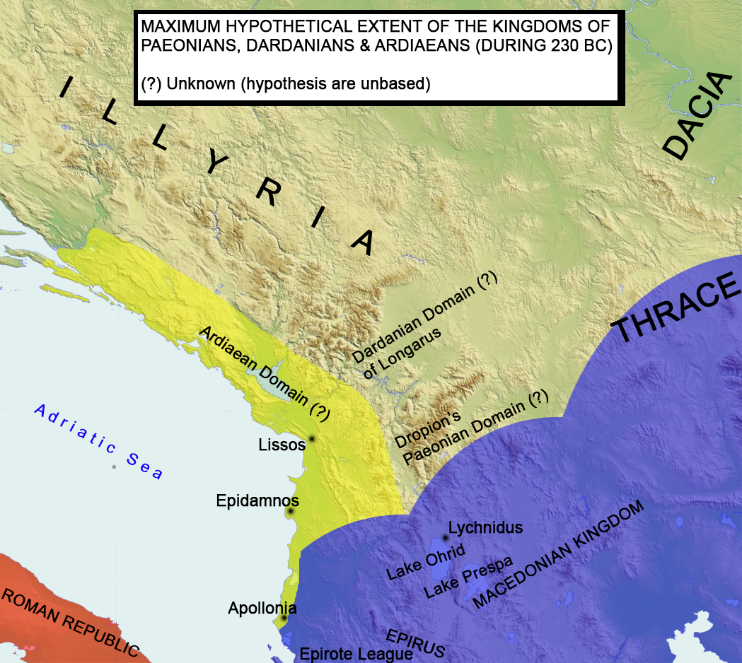
English: Paeonian, Ardiaean (Ilyrian), Dardanian kingdoms extent during 230 BC. Maximum hypothetical extent.
Français : Extension hypothétique du royaume illyrien vers 230 av. J.-C.. |
| Date | |
| Source | Travail personnel |
| Auteur | MaryroseB54 |
- Epire, Illyrie, Macedoine: melanges offerts au professeur Pierre Cabanes by Daniele Berranger,Pierre Cabanes,Daniele Berranger-Auserve,page 136,"The extent of the kingdom of Agron and Teuta is not known exactly"
- Studies concerning Epirus and Macedonia before Alexander by Nicholas Geoffrey Lempriere Hammond, concludes that Agron's domain was of regional significance only and if he even called himself king of the Illyrians is questioned.That he was an Ardiaean king and he extented his rule into other tribes as well, but thats it.
- A History of Macedonia: 336-167 B.C By Nicholas Geoffrey Lempriere Hammond, Frank William Walbank,1988,ISBN -0198148151
- Epire, Illyrie, Macedoine: melanges offerts au professeur Pierre Cabanes by Daniele Berranger,Pierre Cabanes,Daniele Berranger-Auserve
- The Illyrians by J. J. Wilkes,1992,ISBN 0631198075,
- Epirus, 4000 years of Greek history and civilization by M. B. Hatzopoulos
- Diadokhoi Maps by Mladjov (see here) of http://umich.edu/ University of Michigan
- Blank map,File:Yugoslavia_topographic_base_map.svg
Conditions d’utilisation[modifier]
_DARDANIAN_KINGDOMS_EXTENT_DURING_230_BC.png&action=edit§ion=2)
Moi, en tant que détenteur des droits d’auteur sur cette œuvre, je la publie sous la licence suivante :
Ce fichier est sous la licence Creative Commons Attribution – Partage dans les Mêmes Conditions 4.0 International.
- Vous êtes libre :
- de partager – de copier, distribuer et transmettre cette œuvre
- d’adapter – de modifier cette œuvre
- Sous les conditions suivantes :
- paternité – Vous devez donner les informations appropriées concernant l'auteur, fournir un lien vers la licence et indiquer si des modifications ont été faites. Vous pouvez faire cela par tout moyen raisonnable, mais en aucune façon suggérant que l’auteur vous soutient ou approuve l’utilisation que vous en faites.
- partage à l’identique – Si vous modifiez, transformez, ou vous basez sur cette œuvre, vous devez distribuer votre contribution sous la même licence ou une licence compatible avec celle de l’original.
| Annotations | Cette image est annotée : Voir les annotations sur Wikimedia Commons |
_DARDANIAN_KINGDOMS_EXTENT_DURING_230_BC.png)
Historique du fichier
Cliquer sur une date et heure pour voir le fichier tel qu'il était à ce moment-là.
| Date et heure | Vignette | Dimensions | Utilisateur | Commentaire | |
|---|---|---|---|---|---|
| actuel | 13 juillet 2016 à 13:14 | | 1 049 × 938 (1,88 Mio) | MaryroseB54 (d | contributions) | Epirote League, Epirus |
| 13 juillet 2016 à 12:05 |  | 1 049 × 938 (1,88 Mio) | MaryroseB54 (d | contributions) | User created page with UploadWizard |
Vous ne pouvez pas remplacer ce fichier.
Utilisations locales du fichier
Les 5 pages suivantes utilisent ce fichier :
Utilisations du fichier sur d’autres wikis
Les autres wikis suivants utilisent ce fichier :
- Utilisation sur bs.wikipedia.org
- Utilisation sur da.wikipedia.org
- Utilisation sur fr.wikipedia.org
- Utilisation sur ja.wikipedia.org
- Utilisation sur pl.wikipedia.org
- Utilisation sur sq.wikipedia.org
- Utilisation sur sv.wikipedia.org
- Utilisation sur uk.wikipedia.org
Métadonnées
_DARDANIAN_KINGDOMS_EXTENT_DURING_230_BC.png&oldid=698042225)
Catégories :
- Maps of the ancient Kingdom of Illyria
- Antigonid dynasty
- Maps of the Hellenistic world
- Maps of the history of the ancient Balkans
- Maps of the history of Albania in ancient times
- Maps of the history of Kosovo in ancient times
- Maps of the history of Montenegro in ancient times
- Maps of the history of Croatia in ancient times
- Maps of the history of Dalmatia
- Maps showing 3rd-century BC history
- 230s BC
- 220s BC
- Agron of Illyria
- Kingdom of Dardania