File:PIA00011 Cylindrical Projection of Jupiter.jpg
Jump to navigation
Jump to search
Size of this preview: 799 × 214 pixels. Other resolutions: 320 × 86 pixels | 640 × 172 pixels | 2,000 × 536 pixels.
Original file (2,000 × 536 pixels, file size: 93 KB, MIME type: image/jpeg)
Captions
Captions
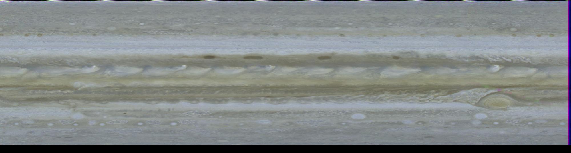
Cylindrical Projection of Jupiter
Summary
[edit]
| Description |
English: This computer generated map of Jupiter was made from 10 color images of Jupiter taken Feb. 1, 1979, by Voyager 1, during a single, 10 hour rotation of the planet. Computers at Jet Propulsion Laboratory's Image Processing Lab then turned the photos into this cylindrical projection. Such a projection is invaluable as an instantaneous view of the entire planet. Along the northern edge of the north equatorial belt (NEB) are four dark brown, oblong regions believed by some scientists to be openings in the more colorful upper cloud decks, allowing the darker clouds beneath to be seen. The broad equatorial zone (EZ) is dominated by a series of plumes, possibly regions of intense convective activity, encircling the entire planet. In the southern hemisphere the Great Red Spot is located at about 75 degrees longitude. South of the Great Red Spot in the south temperate zone (STeZ) three large white ovals, seen from Earth-based observatories for the past few decades, are located at 5 degrees, 85 degrees and 170 degrees longitude. Resolution in this map is 375 miles (600 kilometers). Since Jupiter's atmospheric features drift around the planet, longitude is based on the orientation of the planet's magnetic field. Symbols at right edge of photo denote major atmospheric features (dark belts and light zones): NTeZ - north temperate zone; NTrZ - north tropical zone; NEB - north equatorial belt; EZ - equatorial zone; SEB - south equatorial belt; STrZ - south tropical zone; and STeZ - south temperate zone. Voyager belt; EZ - equatorial zone; SEB - south tropical zone; Voyager is managed for NASA's Office of Space Science by Jet Propulsion Laboratory. |
| Date | |
| Source | https://photojournal.jpl.nasa.gov/catalog/PIA00011 |
| Author | NASA/JPL |
Licensing
[edit]
| This file is in the public domain in the United States because it was solely created by NASA. NASA copyright policy states that "NASA material is not protected by copyright unless noted". (See Template:PD-USGov, NASA copyright policy page or JPL Image Use Policy.) | ||
 |
Warnings:
|
File history
Click on a date/time to view the file as it appeared at that time.
| Date/Time | Thumbnail | Dimensions | User | Comment | |
|---|---|---|---|---|---|
| current | 10:01, 13 March 2024 | 2,000 × 536 (93 KB) | JCP-JohnCarlo (talk | contribs) | Uploaded a work by NASA/JPL from https://photojournal.jpl.nasa.gov/catalog/PIA00011 with UploadWizard |
You cannot overwrite this file.
File usage on Commons
There are no pages that use this file.