File:PIA00245 Baltis Vallis.jpg

原始文件 (2,150 × 2,150像素,文件大小:1.99 MB,MIME类型:image/jpeg)
说明
说明
摘要
[编辑]
| 描述 |
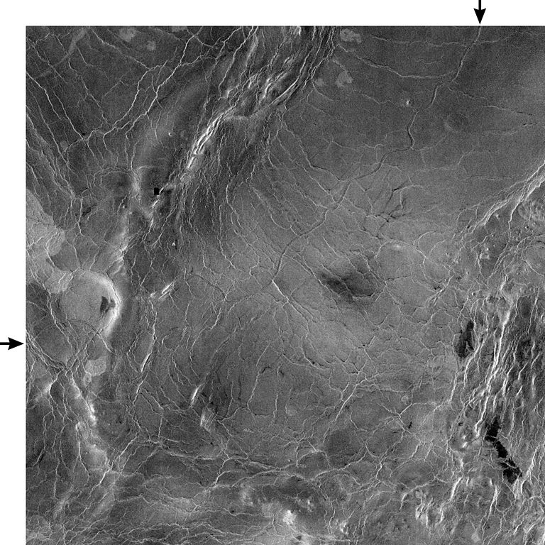
PIA00245: Venus - 600 Kilometer Segment of Longest Channel on Venus This compressed resolution radar mosaic from Magellan at 49 degrees north latitude, 165 degrees east longitude with dimensions of 460 by 460 kilometers (285 by 285 miles), shows a 600 kilometers (360 mile) segment of the longest channel discovered on Venus to date. The channel is approximately 1.8 kilometers (1.1 miles) wide. At more than 7,000 kilometers (4,200 miles) long, it is several hundred kilometers longer than the Nile River, Earth's longest river, thus making it the longest known channel in the solar system. Both ends of the channel are obscured, however, so its original length is unknown. The channel was initially discovered by the Soviet Venera 15-16 orbiters which, in spite of their one kilometer resolution, detected more than 1,000 kilometers (620 miles) of the channel. These channel-like features are common on the plains of Venus. In some places they appear to have been formed by lava which may have melted or thermally eroded a path over the plains' surface. Most are 1 to 3 kilometers (0.6 to 2 miles) wide. They resemble terrestrial meandering rivers in some aspects, with meanders, cutoff bows and abandoned channel segments. However, Venus channels are not as tightly sinuous as terrestrial rivers. Most are partly buried by younger lava plains, making their sources difficult to identify. A few have vast radar-dark plains units associated with them, suggesting large flow volumes. These channels, with large deposits appear to be older than other channel types, as they are crossed by fractures and wrinkle ridges, and are often buried by other volcanic materials. In addition, they appear to run both upslope and downslope, suggesting that the plains were warped by regional tectonism after channel formation. Resolution of the Magellan data is about 120 meters (400 feet). The white margins and arrows have been added to the NASA image. |
| 日期 | |
| 来源 | http://photojournal.jpl.nasa.gov/catalog/PIA00245 |
| 作者 | NASA/Jet Propulsion Lab |
| 此标签不表示文件的著作权状态。任何文件在附有此标签的同時还需要一个有效的著作权标签。请参阅许可协议说明页面以了解更多信息。 其他语言:
|
许可协议
[编辑]
| 本文件完全由NASA创作,在美国属于公有领域。根据NASA的版权方针,NASA的材料除非另有声明否则不受版权保护。(参见Template:PD-USGov/zh、NASA版权方针页面或JPL图片使用方针。) | ||
 |
警告:
|
文件历史
点击某个日期/时间查看对应时刻的文件。
| 日期/时间 | 缩略图 | 大小 | 用户 | 备注 | |
|---|---|---|---|---|---|
| 当前 | 2007年12月8日 (六) 19:07 | | 2,150 × 2,150(1.99 MB) | WolfmanSF(留言 | 贡献) | {{Information |Description=PIA00245: Venus - 600 Kilometer Segment of Longest Channel on Venus This compressed resolution radar mosaic from Magellan at 49 degrees north latitude, 165 degrees east longitude with dimensions of 460 by 460 kilometers (285 by |
您不可以覆盖此文件。
文件用途
以下页面使用本文件:
全域文件用途
以下其他wiki使用此文件:
- en.wikipedia.org上的用途
- fi.wikipedia.org上的用途
- fr.wikipedia.org上的用途
- gl.wikipedia.org上的用途
- hu.wikipedia.org上的用途
- it.wikipedia.org上的用途
- uk.wikipedia.org上的用途
- www.wikidata.org上的用途
- zh.wikipedia.org上的用途