File:PIA02035 Map of Mars' Topography.jpg
跳至導覽
跳至搜尋

預覽大小:800 × 510 像素。 其他解析度:320 × 204 像素 | 640 × 408 像素 | 1,024 × 652 像素 | 1,280 × 815 像素 | 2,761 × 1,759 像素。
原始檔案 (2,761 × 1,759 像素,檔案大小:1.06 MB,MIME 類型:image/jpeg)
說明
說明
添加單行說明來描述出檔案所代表的內容
摘要
[編輯]
| 描述 |
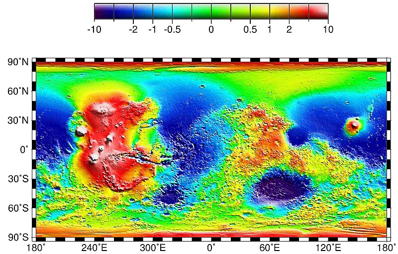
English: Map of Mars' topography with zonal spherical harmonic degree 1 (COM/COF offset along the polar z-axis) removed. The projection is rectangular to show topography from pole to pole. Note the general similarity in elevation between the northern and southern hemispheres. The figure highlights the two other significant components of martian topography: the Tharsis province and the Hellas impact basin. Here we have not removed shorter-wavelength topographic features, including those comprising the dichotomy boundary scarp. |
| 日期 | (published) |
| 來源 | Catalog page · Full-res (JPEG · TIFF) |
| 作者 | NASA/JPL/GSFC |
| 此標籤不表示文件的著作權狀態。任何文件在附有此標籤的同時還需要一個有效的著作權標籤。請參閱許可協議說明頁面以了解更多資訊。 其他語言:
|
| This media is a product of the Mars Global Surveyor mission Credit and attribution belongs to the Mars Orbiter Laser Altimeter (MOLA) team, NASA/JPL/GSFC |
授權條款
[編輯]
| 本作品由NASA創作,屬於公有領域。根據NASA的版權政策:“NASA的創作除非另有聲明否則不受版權保護。”(參見:Template:PD-USGov/zh,NASA版權政策或JPL圖像使用政策) | ||
 |
警告:
|
原始上傳日誌
[編輯]
The original description page was here. All following user names refer to en.wikipedia.
| 日期/時間 | 尺寸 | 使用者 | 備註 |
|---|---|---|---|
| 2011-01-17 14:37 | 2761×1759× (1115263 bytes) | Schaffman | {{Information |Description = MOLA topographic Map of Mars |Source = http://photojournal.jpl.nasa.gov/catalog/PIA02035 |Date = ~~~~~ |Author = NASA/JPL/Goddard Spaceflight Center |Permission = JPL Public Use Policy |o |
檔案歷史
點選日期/時間以檢視該時間的檔案版本。
| 日期/時間 | 縮圖 | 尺寸 | 使用者 | 備註 | |
|---|---|---|---|---|---|
| 目前 | 2016年12月7日 (三) 03:08 | | 2,761 × 1,759(1.06 MB) | BD2412(留言 | 貢獻) | Transferred from en.wikipedia |
無法覆蓋此檔案。
檔案用途
下列頁面有用到此檔案:
- File:Mars Global Topo PIA02035.jpg (檔案重新導向)
全域檔案使用狀況
以下其他 wiki 使用了這個檔案: