File:PIA05482 modest.jpg
跳转到导航
跳转到搜索
没有更高的分辨率。
PIA05482_modest.jpg (447 × 333像素,文件大小:21 KB,MIME类型:image/jpeg)
说明
说明
添加一行文字以描述该文件所表现的内容
摘要
[编辑]
| 描述 |
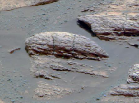
English: This image taken by the Mars Exploration Rover Opportunity's panoramic camera shows the rock nicknamed "Last Chance," which lies within the outcrop near the rover's landing site at Meridiani Planum, Mars. The image provides evidence for a geologic feature known as ripple cross-stratification. At the base of the rock, layers can be seen dipping downward to the right. The bedding that contains these dipping layers is only one to two centimeters (0.4 to 0.8 inches) thick. In the upper right corner of the rock, layers also dip to the right, but exhibit a weak "concave-up" geometry. These two features -- the thin, cross-stratified bedding combined with the possible concave geometry -- suggest small ripples with sinuous crest lines. Although wind can produce ripples, they rarely have sinuous crest lines and never form steep, dipping layers at this small scale. The most probable explanation for these ripples is that they were formed in the presence of moving water. |
| 日期 | |
| 来源 | http://photojournal.jpl.nasa.gov/catalog/pia05482 |
| 作者 | NASA/JPL/Cornell |
| 此标签不表示文件的著作权状态。任何文件在附有此标签的同時还需要一个有效的著作权标签。请参阅许可协议说明页面以了解更多信息。 其他语言:
|
许可协议
[编辑]
| 本文件完全由NASA创作,在美国属于公有领域。根据NASA的版权方针,NASA的材料除非另有声明否则不受版权保护。(参见Template:PD-USGov/zh、NASA版权方针页面或JPL图片使用方针。) | ||
 |
警告:
|
原始上传日志
[编辑]
原始描述頁面位於這裡。下列使用者名稱均來自en.wikipedia。
- 2004-03-02 23:37 Perl 447×333× (21804 bytes) This image taken by the Mars Exploration Rover Opportunity's panoramic camera shows the rock nicknamed "Last Chance," which lies within the outcrop near the rover's landing site at Meridiani Planum, Mars. The image provides evidence for a geologic feature
文件历史
点击某个日期/时间查看对应时刻的文件。
| 日期/时间 | 缩略图 | 大小 | 用户 | 备注 | |
|---|---|---|---|---|---|
| 当前 | 2009年5月28日 (四) 22:50 | | 447 × 333(21 KB) | File Upload Bot (Magnus Manske)(留言 | 贡献) | {{BotMoveToCommons|en.wikipedia|year={{subst:CURRENTYEAR}}|month={{subst:CURRENTMONTHNAME}}|day={{subst:CURRENTDAY}}}} {{Information |Description={{en|This image taken by the Mars Exploration Rover Opportunity's panoramic camera shows the rock nicknamed |
您不可以覆盖此文件。
文件用途
没有页面使用本文件。
全域文件用途
以下其他wiki使用此文件:
- ca.wikipedia.org上的用途
- en.wikipedia.org上的用途
- Adirondack (Mars)
- Heat Shield Rock
- Eagle (crater)
- Yogi Rock
- Home Plate (Mars)
- List of rocks on Mars
- Bounce Rock
- Barnacle Bill (Martian rock)
- Pot of Gold (Mars)
- El Capitan (Mars)
- Last Chance (Mars)
- Geology of Mars
- User talk:Drbogdan
- Oileán Ruaidh (Mars rock)
- Composition of Mars
- N165
- Jake Matijevic (rock)
- Bathurst Inlet (rock)
- Hottah (Mars)
- Link (Mars)
- Goulburn (Mars)
- Rocknest 3
- Shelter Island meteorite
- Block Island meteorite
- Mackinac Island meteorite
- Tintina (rock)
- User:Drbogdan/sandbox-templates-Geology-MarsRocks-MoleculesInSpace
- Template:MarsRocks
- Talk:Opportunity (rover)/Archive 1
- es.wikipedia.org上的用途
- pt.wikipedia.org上的用途
- ru.wikipedia.org上的用途
- th.wikipedia.org上的用途
- uk.wikipedia.org上的用途
查看此文件的更多全域用途。