File:PIA05482 modest.jpg
跳至導覽
跳至搜尋
無更高解析度可提供。
PIA05482_modest.jpg (447 × 333 像素,檔案大小:21 KB,MIME 類型:image/jpeg)
說明
說明
添加單行說明來描述出檔案所代表的內容
摘要
[編輯]
| 描述 |
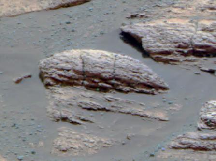
English: This image taken by the Mars Exploration Rover Opportunity's panoramic camera shows the rock nicknamed "Last Chance," which lies within the outcrop near the rover's landing site at Meridiani Planum, Mars. The image provides evidence for a geologic feature known as ripple cross-stratification. At the base of the rock, layers can be seen dipping downward to the right. The bedding that contains these dipping layers is only one to two centimeters (0.4 to 0.8 inches) thick. In the upper right corner of the rock, layers also dip to the right, but exhibit a weak "concave-up" geometry. These two features -- the thin, cross-stratified bedding combined with the possible concave geometry -- suggest small ripples with sinuous crest lines. Although wind can produce ripples, they rarely have sinuous crest lines and never form steep, dipping layers at this small scale. The most probable explanation for these ripples is that they were formed in the presence of moving water. |
| 日期 | |
| 來源 | http://photojournal.jpl.nasa.gov/catalog/pia05482 |
| 作者 | NASA/JPL/Cornell |
| 此標籤不表示文件的著作權狀態。任何文件在附有此標籤的同時還需要一個有效的著作權標籤。請參閱許可協議說明頁面以了解更多資訊。 其他語言:
|
授權條款
[編輯]
| 本作品由NASA創作,屬於公有領域。根據NASA的版權政策:“NASA的創作除非另有聲明否則不受版權保護。”(參見:Template:PD-USGov/zh,NASA版權政策或JPL圖像使用政策) | ||
 |
警告:
|
原始上傳日誌
[編輯]
The original description page was here. All following user names refer to en.wikipedia.
- 2004-03-02 23:37 Perl 447×333× (21804 bytes) This image taken by the Mars Exploration Rover Opportunity's panoramic camera shows the rock nicknamed "Last Chance," which lies within the outcrop near the rover's landing site at Meridiani Planum, Mars. The image provides evidence for a geologic feature
檔案歷史
點選日期/時間以檢視該時間的檔案版本。
| 日期/時間 | 縮圖 | 尺寸 | 使用者 | 備註 | |
|---|---|---|---|---|---|
| 目前 | 2009年5月28日 (四) 22:50 | | 447 × 333(21 KB) | File Upload Bot (Magnus Manske)(留言 | 貢獻) | {{BotMoveToCommons|en.wikipedia|year={{subst:CURRENTYEAR}}|month={{subst:CURRENTMONTHNAME}}|day={{subst:CURRENTDAY}}}} {{Information |Description={{en|This image taken by the Mars Exploration Rover Opportunity's panoramic camera shows the rock nicknamed |
無法覆蓋此檔案。
檔案用途
沒有使用此檔案的頁面。
全域檔案使用狀況
以下其他 wiki 使用了這個檔案:
- ca.wikipedia.org 的使用狀況
- en.wikipedia.org 的使用狀況
- Adirondack (Mars)
- Heat Shield Rock
- Eagle (crater)
- Yogi Rock
- Home Plate (Mars)
- List of rocks on Mars
- Bounce Rock
- Barnacle Bill (Martian rock)
- Pot of Gold (Mars)
- El Capitan (Mars)
- Last Chance (Mars)
- Geology of Mars
- User talk:Drbogdan
- Oileán Ruaidh (Mars rock)
- Composition of Mars
- N165
- Jake Matijevic (rock)
- Bathurst Inlet (rock)
- Hottah (Mars)
- Link (Mars)
- Goulburn (Mars)
- Rocknest 3
- Shelter Island meteorite
- Block Island meteorite
- Mackinac Island meteorite
- Tintina (rock)
- User:Drbogdan/sandbox-templates-Geology-MarsRocks-MoleculesInSpace
- Template:MarsRocks
- Talk:Opportunity (rover)/Archive 1
- es.wikipedia.org 的使用狀況
- pt.wikipedia.org 的使用狀況
- ru.wikipedia.org 的使用狀況
- th.wikipedia.org 的使用狀況
- uk.wikipedia.org 的使用狀況
檢視此檔案的更多全域使用狀況。