File:PIA05484 modest.jpg
原始文件 (1,278 × 352像素,文件大小:40 KB,MIME类型:image/jpeg)
说明
说明
摘要[编辑]
| 描述 |
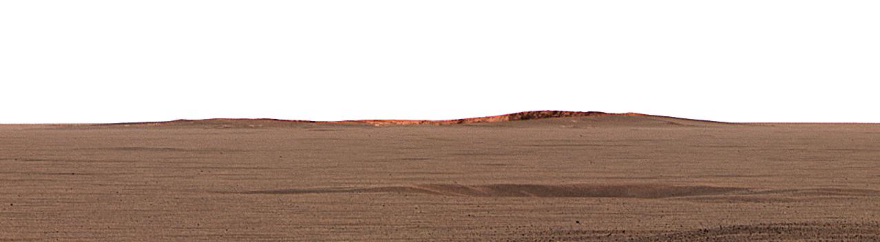
English: This image taken by the Mars Exploration Rover Opportunity's panoramic camera shows the eastern plains that stretch beyond the small crater where the rover landed. In the distance, the rim of a larger crater dubbed "Endurance" can be seen.
This color mosaic was taken on the 32nd martian day, or sol, of the rover's mission and spans 20 degrees of the horizon. It was taken while Opportunity was parked at the north end of the outcrop, in front of the rock region dubbed "El Capitan" and facing east. The features seen at the horizon are the near and far rims of "Endurance," the largest crater within about 6 kilometers (4 miles) of the lander. Using orbital data from the Mars Orbiter Camera on NASA's Mars Global Surveyor spacecraft, scientists estimated the crater to be 160 meters (175 yards) in diameter, and about 720 meters (half a mile) away from the lander. The highest point visible on "Endurance" is the highest point on the far wall of the crater; the sun is illuminating the inside of the far wall. Between the location where the image was taken at "El Capitan" and "Endurance" are the flat, smooth Meridiani plains, which scientists believe are blanketed in the iron-bearing mineral called hematite. The dark horizontal feature near the bottom of the picture is a small, five-meter (16-feet) crater, only 50 meters (164 feet) from Opportunity's present position. When the rover leaves the crater some 2 to 3 weeks from now, "Endurance" is one of several potential destinations. |
| 日期 | |
| 来源 | http://photojournal.jpl.nasa.gov/catalog/PIA05484 |
| 作者 | NASA/JPL/Cornell/MSSS |
| 此标签不表示文件的著作权状态。任何文件在附有此标签的同時还需要一个有效的著作权标签。请参阅许可协议说明页面以了解更多信息。 其他语言:
|
许可协议[编辑]
| 本文件完全由NASA创作,在美国属于公有领域。根据NASA的版权方针,NASA的材料除非另有声明否则不受版权保护。(参见Template:PD-USGov/zh、NASA版权方针页面或JPL图片使用方针。) | ||
 |
警告:
|
原始上传日志[编辑]
- 2004-03-02 23:38 Perl 1100×303× (28911 bytes) This image taken by the Mars Exploration Rover Opportunity's panoramic camera shows the eastern plains that stretch beyond the small crater where the rover landed. In the distance, the rim of a larger crater dubbed "Endurance" can be seen. This color m
文件历史
点击某个日期/时间查看对应时刻的文件。
| 日期/时间 | 缩略图 | 大小 | 用户 | 备注 | |
|---|---|---|---|---|---|
| 当前 | 2013年2月17日 (日) 04:53 | 1,278 × 352(40 KB) | Huntster(留言 | 贡献) | Full size from original source. | |
| 2009年5月28日 (四) 22:51 | 1,100 × 303(28 KB) | File Upload Bot (Magnus Manske)(留言 | 贡献) | {{BotMoveToCommons|en.wikipedia|year={{subst:CURRENTYEAR}}|month={{subst:CURRENTMONTHNAME}}|day={{subst:CURRENTDAY}}}} {{Information |Description={{en|This image taken by the Mars Exploration Rover Opportunity's panoramic camera shows the eastern plains |
您不可以覆盖此文件。
文件用途
没有页面使用本文件。
全域文件用途
以下其他wiki使用此文件:
- en.wikipedia.org上的用途
- fa.wikipedia.org上的用途
- fr.wikipedia.org上的用途
- hr.wikipedia.org上的用途
- ja.wikipedia.org上的用途
- no.wikipedia.org上的用途
- ru.wikipedia.org上的用途
- sv.wikipedia.org上的用途
- uk.wikipedia.org上的用途
- zh.wikipedia.org上的用途