File:PIA10008 Seas and Lakes on Titan.jpg
原始檔案 (2,348 × 1,900 像素,檔案大小:2.62 MB,MIME 類型:image/jpeg)
說明
說明
摘要
[編輯]
| 描述 |
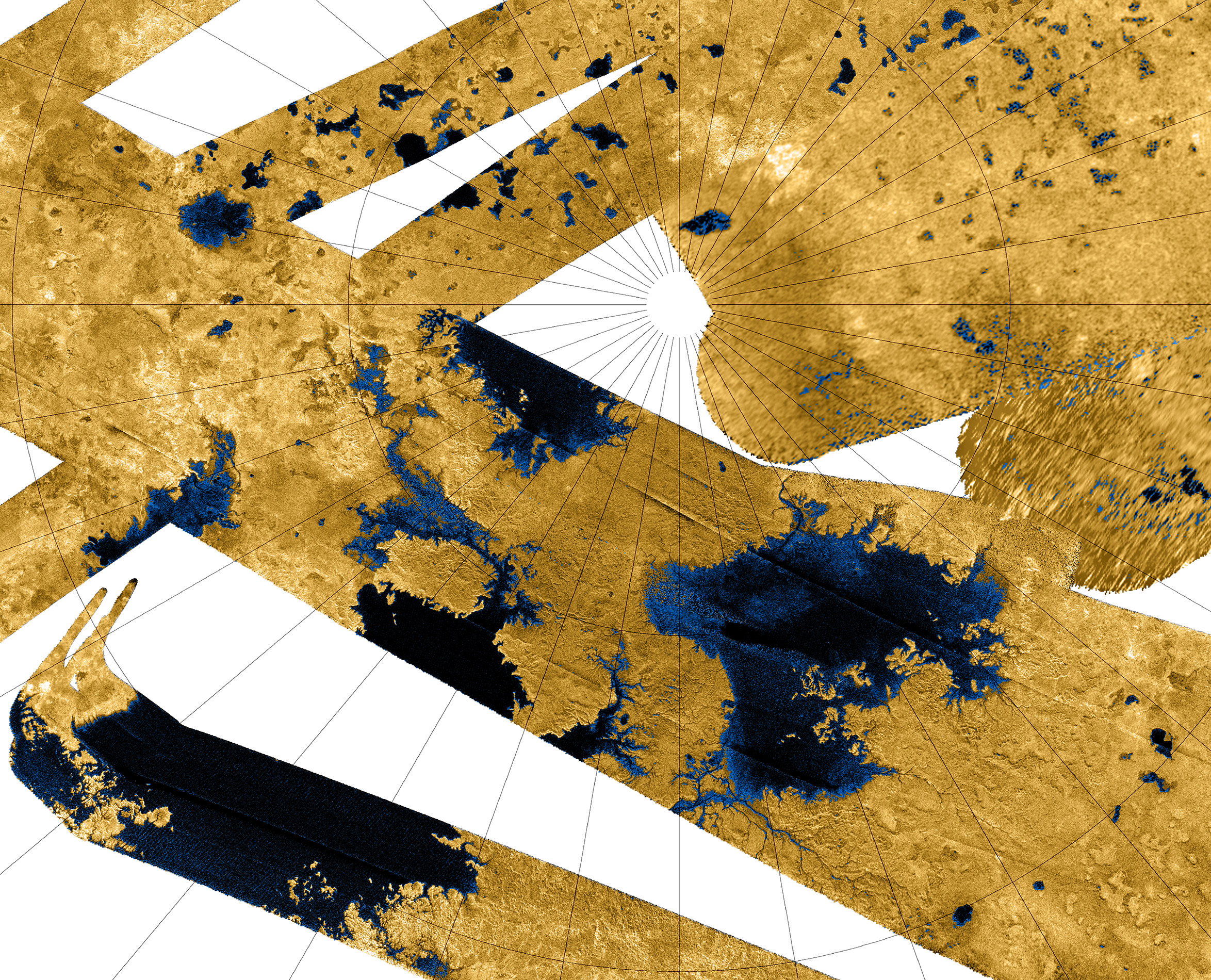
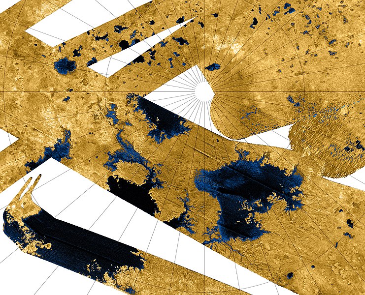
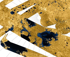
This Cassini false-color mosaic shows all synthetic-aperture radar images to date of Titan's north polar region. Approximately 60 percent of Titan's north polar region, above 60 degrees north latitude, is now mapped with radar. About 14 percent of the mapped region is covered by what is interpreted as liquid hydrocarbon lakes. Features thought to be liquid are shown in blue and black, and the areas likely to be solid surface are tinted brown. The terrain in the upper left of this mosaic is imaged at lower resolution than the remainder of the image Most of the many lakes and seas seen so far are contained in this image, including the largest known body of liquid on Titan. These seas are most likely filled with liquid ethane, methane and dissolved nitrogen. Many bays, islands and presumed tributary networks are associated with the seas. The large feature in the upper right center of this image is at least 100,000 square kilometers (40,000 square miles) in area, greater in extent than Lake Superior (82,000 square kilometers or 32,000 square miles), one of Earth's largest lakes. This Titan feature covers a greater fraction of the surface, at least 0.12 percent, than the Black Sea, Earth's largest terrestrial inland sea, at 0.085 percent. Larger seas may exist, as it is probable that some of these bodies are connected, either in areas unmapped by radar or under the surface (see PIA08365). Of the 400 observed lakes and seas, 70 percent of their area is taken up by large "seas" greater than 26,000 square kilometers (10,000 square miles). The Cassini-Huygens mission is a cooperative project of NASA, the European Space Agency and the Italian Space Agency. The Jet Propulsion Laboratory, a division of the California Institute of Technology in Pasadena, manages the mission for NASA's Science Mission Directorate, Washington, D.C. The Cassini orbiter was designed, developed and assembled at JPL. The radar instrument was built by JPL and the Italian Space Agency, working with team members from the United States and several European countries. For more information about the Cassini-Huygens mission, visit http://saturn.jpl.nasa.gov/home/index.cfm. The original NASA image has been modified by rotating 90 degrees clockwise, cropping and reduction in size (the linear pixel density was reduced 50%). Some of the features in this image have been annotated in Wikimedia Commons. |
| 日期 | |
| 來源 | http://photojournal.jpl.nasa.gov/catalog/?IDNumber=PIA10008 |
| 作者 | NASA / JPL-Caltech / USGS |
| 其他版本 |
PIA10008 Seas and Lakes on Titan full size.jpg - larger, higher resolution version (4696 × 4696 pixels, 10.4 MB) |
| 此標籤不表示文件的著作權狀態。任何文件在附有此標籤的同時還需要一個有效的著作權標籤。請參閱許可協議說明頁面以了解更多資訊。 其他語言:
|
授權條款
[編輯]
| 本作品由NASA創作,屬於公有領域。根據NASA的版權政策:“NASA的創作除非另有聲明否則不受版權保護。”(參見:Template:PD-USGov/zh,NASA版權政策或JPL圖像使用政策) | ||
 |
警告:
|
| 註解 | 該圖片含有註解:在維基媒體共享資源上查看註解 |
檔案歷史
點選日期/時間以檢視該時間的檔案版本。
| 日期/時間 | 縮圖 | 尺寸 | 用戶 | 備註 | |
|---|---|---|---|---|---|
| 目前 | 2013年11月12日 (二) 03:01 | | 2,348 × 1,900(2.62 MB) | WolfmanSF(對話 | 貢獻) | Slightly wider view on top and right |
| 2012年4月8日 (日) 09:44 |  | 2,280 × 1,840(2.1 MB) | WolfmanSF(對話 | 貢獻) | Tweak cropping; add 40 pixels at upper margin to fully display several lakes | |
| 2007年12月16日 (日) 00:18 |  | 2,280 × 1,800(2.05 MB) | WolfmanSF(對話 | 貢獻) | {{Information |Description=This Cassini false-color mosaic shows all synthetic-aperture radar images to date of Titan's north polar region. Approximately 60 percent of Titan's north polar region, above 60 degrees north latitude, is now mapped with radar. |
無法覆蓋此檔案。
檔案用途
下列3個頁面有用到此檔案:
全域檔案使用狀況
以下其他 wiki 使用了這個檔案:
- an.wikipedia.org 的使用狀況
- ar.wikipedia.org 的使用狀況
- be.wikipedia.org 的使用狀況
- ca.wikipedia.org 的使用狀況
- cs.wikipedia.org 的使用狀況
- de.wikipedia.org 的使用狀況
- en.wikipedia.org 的使用狀況
- en.wikiversity.org 的使用狀況
- User:Marshallsumter/Radiation astronomy2/Radios
- Solar System, technical/Titan
- Draft:Original research/Titan
- User:Marshallsumter/Radiation astronomy2/Radios/Quiz
- User:Marshallsumter/Radiation astronomy/Courses/Principles/Hourly 3
- User:Marshallsumter/Radiation astronomy2/Radars
- Astronomy college course/Miranda and Titan
- User:Marshallsumter/Radiation astronomy/Courses/Principles/Final quiz
- Titan/Quiz
- Moon/Quiz
- Stars/Sun/Heliology/Quiz
- Earth/Quiz
- Stars/Reds/Quiz
- User:Marshallsumter/Radiation astronomy1/Millimeters/Quiz
- fi.wikipedia.org 的使用狀況
- fr.wikipedia.org 的使用狀況
- gl.wikipedia.org 的使用狀況
- hy.wikipedia.org 的使用狀況
- id.wikipedia.org 的使用狀況
- it.wikipedia.org 的使用狀況
- ja.wikipedia.org 的使用狀況
- mk.wikipedia.org 的使用狀況
- nn.wikipedia.org 的使用狀況
- no.wikipedia.org 的使用狀況
檢視此檔案的更多全域使用狀況。