File:PIA11704 - Pits and Channels of Hebrus Valles.jpg

原始文件 (4,500 × 3,000像素,文件大小:2.43 MB,MIME类型:image/jpeg)
说明
说明
摘要
[编辑]
| 描述 |
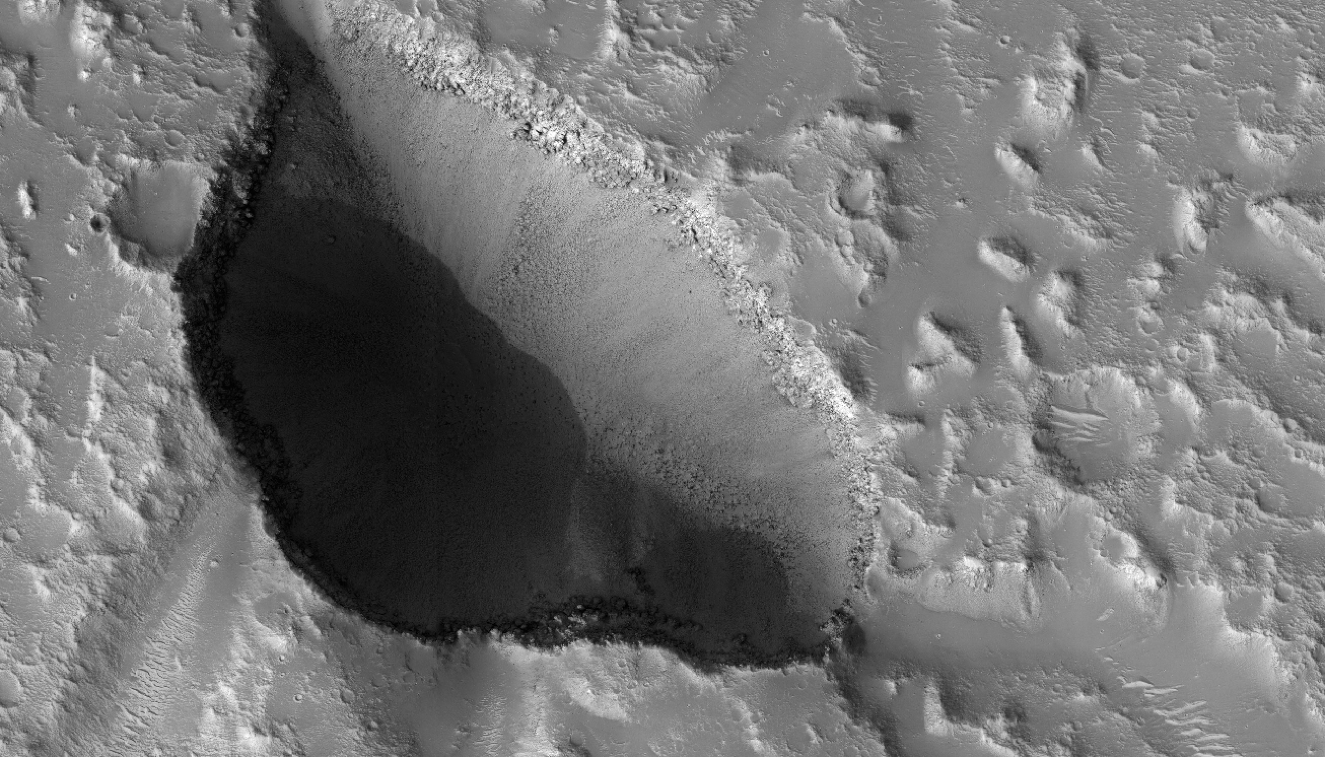
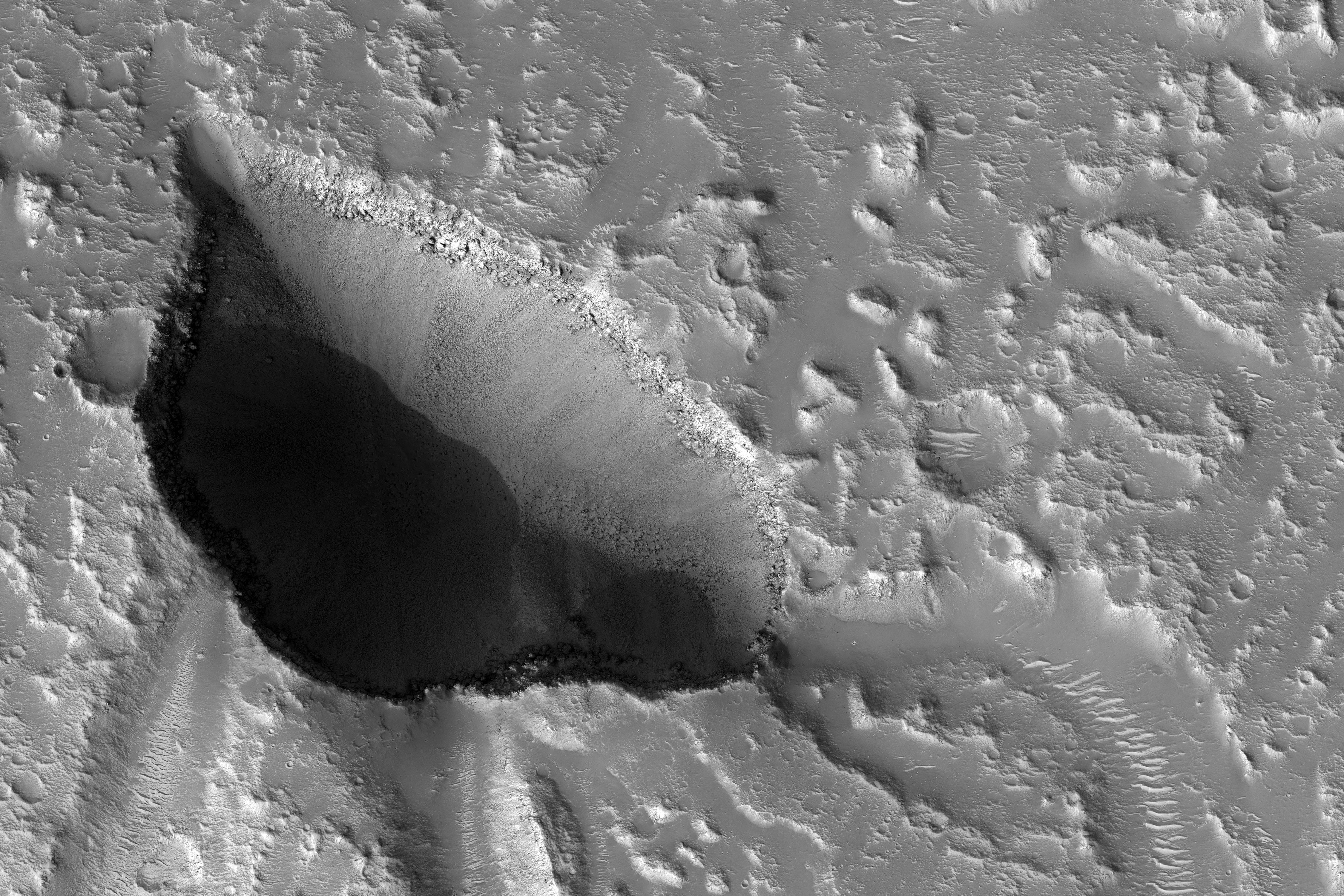
English: The drainages in this image are part of Hebrus Valles, an outflow channel system likely formed by catastrophic floods.
Hebrus Valles is located in the plains of the Northern lowlands, just west of the Elysium volcanic region. Individual channels range from several hundred meters to several kilometers wide and form multi-threaded (anastamosing) patterns. Separating the channels are streamlined forms, whose tails point downstream and indicate that channel flow is to the north. The channels seemingly terminate in an elongated pit that is approximately 1875 meters long and 1125 meters wide. Using the shadow that the wall has cast on the floor of the pit, we can estimate that the pit is nearly 500 meters deep. The pit, which formed after the channels, exposes a bouldery layer below the dusty surface mantle and is underlain by sediments. Boulders several meters in diameter litter the slopes down into the pit. Pits such as these are of interest as possible candidate landing sites for human exploration because they might retain subsurface water ice (Schulze-Makuch et al. 2016, 6th Mars Polar Conf.) that could be utilized by future long-term human settlements. The University of Arizona, Tucson, operates HiRISE, which was built by Ball Aerospace & Technologies Corp., Boulder, Colo. NASA's Jet Propulsion Laboratory, a division of Caltech in Pasadena, California, manages the Mars Reconnaissance Orbiter Project for NASA's Science Mission Directorate, Washington. |
| 日期 | 25 October 2016 (published 26 January 2017) |
| 来源 | Catalog page · Full-res (JPEG · TIFF) |
| 作者 | NASA/JPL-Caltech/Univ. of Arizona |
| 火星上的位置 | 在以下服务上查看本图像和附近其他图像: Google地图 |
|---|
| 此标签不表示文件的著作权状态。任何文件在附有此标签的同時还需要一个有效的著作权标签。请参阅许可协议说明页面以了解更多信息。 其他语言:
|
 |
This media is a product of the Mars Reconnaissance Orbiter mission Credit and attribution belongs to the High Resolution Imaging Science Experiment (HiRISE) team, NASA/JPL-Caltech/Univ. of Arizona |
许可协议
[编辑]
| 本文件完全由NASA创作,在美国属于公有领域。根据NASA的版权方针,NASA的材料除非另有声明否则不受版权保护。(参见Template:PD-USGov/zh、NASA版权方针页面或JPL图片使用方针。) | ||
 |
警告:
|
文件历史
点击某个日期/时间查看对应时刻的文件。
| 日期/时间 | 缩略图 | 大小 | 用户 | 备注 | |
|---|---|---|---|---|---|
| 当前 | 2017年1月28日 (六) 17:27 | | 4,500 × 3,000(2.43 MB) | PhilipTerryGraham(留言 | 贡献) | User created page with UploadWizard |
您不可以覆盖此文件。
文件用途
全域文件用途
以下其他wiki使用此文件:
- cs.wikipedia.org上的用途
- uk.wikipedia.org上的用途
- zh.wikipedia.org上的用途