File:PIA11858 Starburst Spider.jpg
原始文件 (2,560 × 1,920像素,文件大小:712 KB,MIME类型:image/jpeg)
说明
说明
摘要
[编辑]
| 描述 |
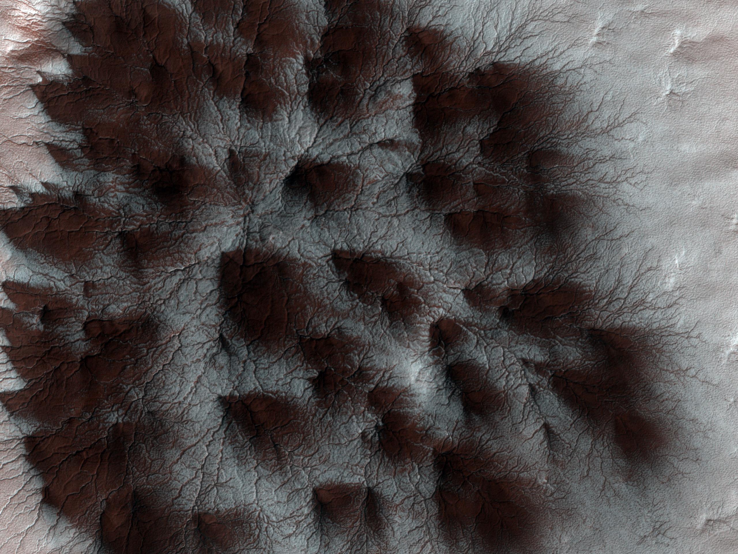
English: Mars' seasonal cap of carbon dioxide ice has eroded many beautiful terrains as it sublimates (goes directly from ice to vapor) every spring. In the region where the High Resolution Imaging Science Experiment (HiRISE) camera on NASA's Mars Reconnaissance Orbiter took this image, we see troughs that form a starburst pattern. In other areas these radial troughs have been refered to as spiders, simply because of their shape. In this region the pattern looks more dendritic as channels branch out numerous times as they get further from the center.
The troughs are believed to be formed by gas flowing beneath the seasonal ice to openings where the gas escapes, carrying along dust from the surface below. The dust falls to the surface of the ice in fan-shaped deposits. This image, covering an area about 1 kilometer (0.6 mile) across, is a portion of the HiRISE observation cataloguedas ESP_011842_0980, taken on Feb. 4, 2009. The observation is centered at 81.8 degrees south latitude, 76.2 degrees east longitude. The image was taken at a local Mars time of 4:56 PM and the scene is illuminated from the west with a solar incidence angle of 78 degrees, thus the sun was about 12 degrees above the horizon. At a solar longitude of 203.6 degrees, the season on Mars is northern autumn. NASA's Jet Propulsion Laboratory, a division of the California Institute of Technology in Pasadena, manages the Mars Reconnaissance Orbiter for NASA's Science Mission Directorate, Washington. Lockheed Martin Space Systems, Denver, is the prime contractor for the project and built the spacecraft. The High Resolution Imaging Science Experiment is operated by the University of Arizona, Tucson, and the instrument was built by Ball Aerospace & Technologies Corp., Boulder, Colo. |
||
| 日期 | |||
| 来源 |
http://photojournal.jpl.nasa.gov/catalog/PIA11858
|
||
| 作者 | NASA/JPL-Caltech/University of Arizona |
许可协议
[编辑]
| 本文件完全由NASA创作,在美国属于公有领域。根据NASA的版权方针,NASA的材料除非另有声明否则不受版权保护。(参见Template:PD-USGov/zh、NASA版权方针页面或JPL图片使用方针。) | ||
 |
警告:
|
文件历史
点击某个日期/时间查看对应时刻的文件。
| 日期/时间 | 缩略图 | 大小 | 用户 | 备注 | |
|---|---|---|---|---|---|
| 当前 | 2009年8月30日 (日) 19:13 | | 2,560 × 1,920(712 KB) | WolfmanSF(留言 | 贡献) | {{Information |Description={{en|1=Mars' seasonal cap of carbon dioxide ice has eroded many beautiful terrains as it sublimates (goes directly from ice to vapor) every spring. In the region where the High Resolution Imaging Science Experiment (HiRISE) came |
您不可以覆盖此文件。
文件用途
没有页面使用本文件。
全域文件用途
以下其他wiki使用此文件:
- ca.wikipedia.org上的用途
- ckb.wikipedia.org上的用途
- en.wikipedia.org上的用途
- es.wikipedia.org上的用途
- et.wikipedia.org上的用途
- hr.wikipedia.org上的用途
- it.wikipedia.org上的用途
- pnb.wikipedia.org上的用途
- ro.wikipedia.org上的用途
- uk.wikipedia.org上的用途
- ur.wikipedia.org上的用途
- zh.wikipedia.org上的用途