File:PIA13804-MarsPhoenixLander-Panorama-20080525b.jpg
原始檔案 (5,236 × 1,236 像素,檔案大小:947 KB,MIME 類型:image/jpeg)
說明
說明
摘要
[編輯]
| 描述 |
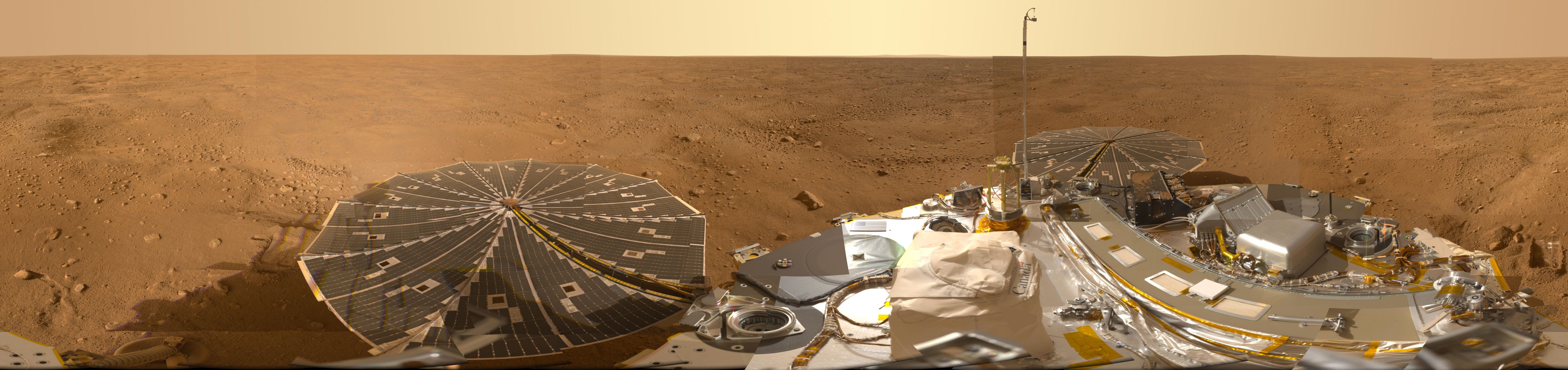
English: PIA13804: Mars Panorama of Phoenix Landing Site and Lander Deck
Target Name: Mars Is a satellite of: Sol (our sun) Mission: Phoenix Spacecraft: Phoenix Lander Instrument: Surface Stereo Imager (SSI) Product Size: 26180 x 6180 pixels (width x height) Produced By: University of Arizona Full-Res TIFF: PIA13804.tif (485.4 MB) Full-Res JPEG: PIA13804.jpg (14.63 MB) This view combines hundreds of images taken during the first several weeks after NASA's Phoenix Mars Lander arrived on an arctic plain at 68.22 degrees north latitude, 234.25 degrees east longitude on Mars. The landing was on May 25, 2008. The full-circle panorama in approximately true color shows the polygonal patterning of ground at the landing area, similar to patterns in permafrost areas on Earth. The center of the image is the westward part of the scene. Trenches where Phoenix's robotic arm has been exposing subsurface material are visible in the right half of the image. The spacecraft's meteorology mast, topped by the telltale wind gauge, extends into the sky portion of the panorama. Other Phoenix instruments, the lander's deck, and its two solar arrays are also visible. The robotic arm is not in the scene. This view comprises more than 100 different camera pointings, with images taken through three different filters at each pointing. It is presented here as a cylindrical projection. The Phoenix Mars Lander mission was led by the University of Arizona, Tucson, on behalf of NASA. Project management of the mission was by NASA's Jet Propulsion Laboratory, Pasadena, Calif. Spacecraft development was by Lockheed Martin Space Systems, Denver. |
| 日期 | |
| 來源 | http://photojournal.jpl.nasa.gov/catalog/PIA13804 (image link) |
| 作者 | NASA/JPL-Caltech/University of Arizona/Texas A&M University |
| 此標籤不表示文件的著作權狀態。任何文件在附有此標籤的同時還需要一個有效的著作權標籤。請參閱許可協議說明頁面以了解更多資訊。 其他語言:
|
授權條款
[編輯]
| 本作品由NASA創作,屬於公有領域。根據NASA的版權政策:“NASA的創作除非另有聲明否則不受版權保護。”(參見:Template:PD-USGov/zh,NASA版權政策或JPL圖像使用政策) | ||
 |
警告:
|
檔案歷史
點選日期/時間以檢視該時間的檔案版本。
| 日期/時間 | 縮圖 | 尺寸 | 用戶 | 備註 | |
|---|---|---|---|---|---|
| 目前 | 2012年10月22日 (一) 17:57 | 5,236 × 1,236(947 KB) | Drbogdan(對話 | 貢獻) | User created page with UploadWizard |
無法覆蓋此檔案。
檔案用途
沒有使用此檔案的頁面。
全域檔案使用狀況
以下其他 wiki 使用了這個檔案:
- en.wikipedia.org 的使用狀況
- et.wikipedia.org 的使用狀況
- kw.wikipedia.org 的使用狀況
- ru.wikipedia.org 的使用狀況
- uk.wikipedia.org 的使用狀況
- zh.wikipedia.org 的使用狀況