File:PIA14470 Ice, Salt and Warm-Season Flows on Mars.jpg

原始檔案 (2,536 × 1,465 像素,檔案大小:777 KB,MIME 類型:image/jpeg)
說明
說明
摘要
[編輯]| 描述 |
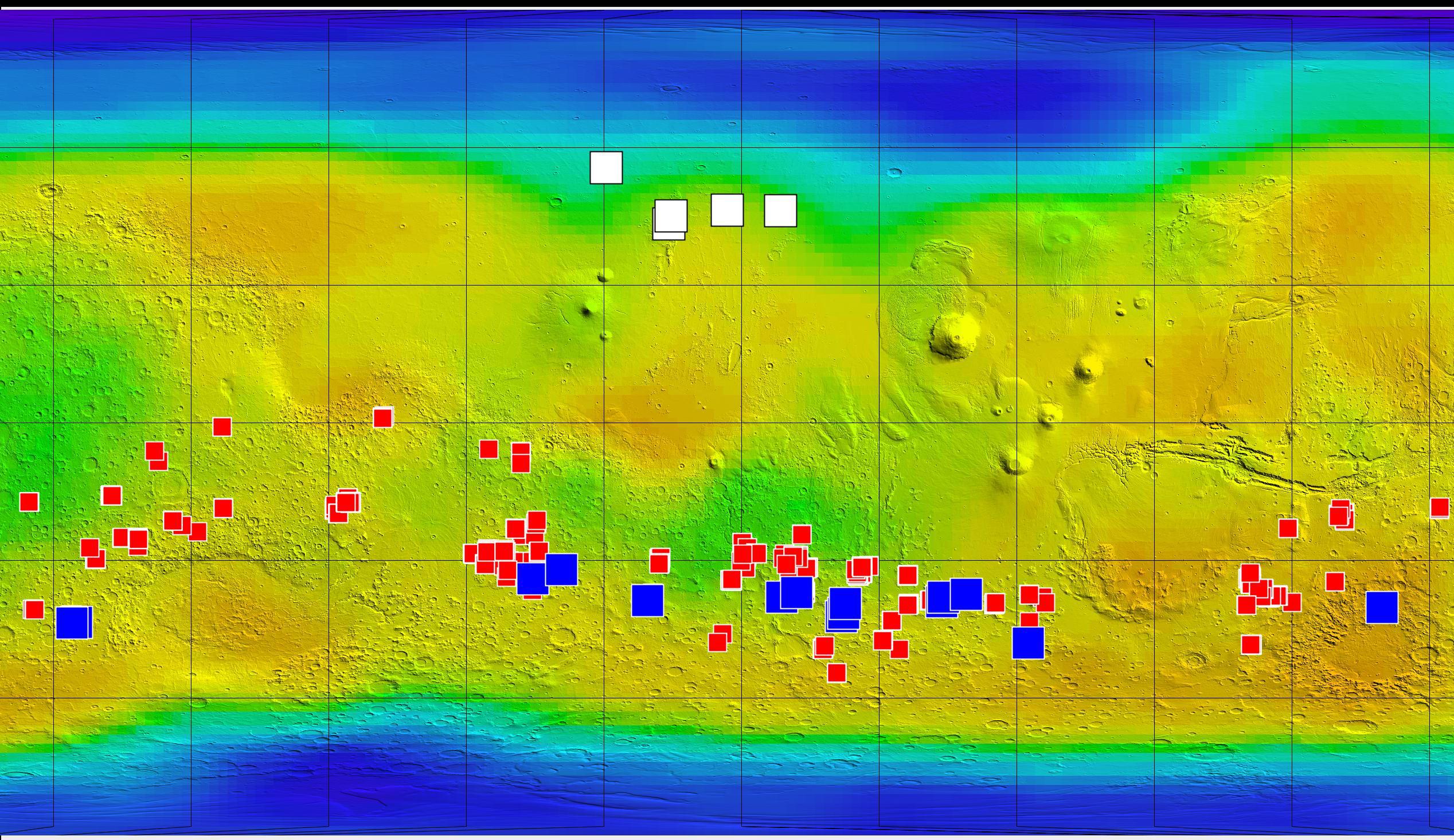
English: This map of Mars shows relative locations of three types of findings related to salt or frozen water, plus a new type of finding that may be related to both salt and water.
Coloring of the map is coded to concentrations of shallow subsurface water ice found by the Gamma Ray Spectrometer - Neutron Spectrometer on NASA's Mars Odyssey orbiter. Blue, at high latitudes north and south, indicates higher concentrations of water ice (deduced from detection of hydrogen); orange designates lowest concentrations. Some hydrogen, possibly in the form of bound water, is close to the surface even at middle latitudes. The white squares in the northern hemisphere mark locations of small fresh impact craters that exposed water ice close to the surface and validated the neutron spectrometer data. Observations of these fresh craters were made by the Context Camera and the High Resolution Imaging Science Experiment camera on NASA's Mars Reconnaissance Orbiter. The red squares mark locations of putative deposits of chloride based on observations by the Thermal Emission Imaging System on Mars Odyssey. Such salt deposits could have resulted from evaporation of salty water. The blue squares mark locations of a type of feature reported in August 2011 based on sequences of observations by the High Resolution Imaging Science Experiment. The observations show relatively dark features appearing and incrementally growing down slopes during warm seasons. Researchers hypothesize that these features may result from action of briny water. Other imagery related to these new findings from the Mars Reconnaissance Orbiter is at http://www.nasa.gov/mission_pages/MRO/multimedia/gallery/gallery-index.html. |
| 日期 | (published) |
| 來源 | Catalog page · Full-res (JPEG · TIFF) |
| 作者 | NASA/JPL-Caltech/ASU/UA/LANL/MSSS |
| 其他版本 |
|


| 此標籤不表示文件的著作權狀態。任何文件在附有此標籤的同時還需要一個有效的著作權標籤。請參閱許可協議說明頁面以了解更多資訊。 其他語言:
|
| This media is a product of the 2001 Mars Odyssey mission Credit and attribution belongs to the Gamma Ray Spectrometer (GRS) team, NASA/JPL-Caltech/ASU/UA/LANL/MSSS |
授權條款
[編輯]
| 本作品由NASA創作,屬於公有領域。根據NASA的版權政策:“NASA的創作除非另有聲明否則不受版權保護。”(參見:Template:PD-USGov/zh,NASA版權政策或JPL圖像使用政策) | ||
 |
警告:
|
原始上傳日誌
[編輯]
| 日期/時間 | 尺寸 | 使用者 | 備註 |
|---|---|---|---|
| 2011-08-05 05:48 | 2536×1465× (795711 bytes) | Surajt88 | == Summary == {{Information |Description =This map of Mars shows relative locations of three types of findings related to salt or frozen water, plus a new type of finding that may be related to both salt and water. Coloring of the map is coded to con |
檔案歷史
點選日期/時間以檢視該時間的檔案版本。
| 日期/時間 | 縮圖 | 尺寸 | 使用者 | 備註 | |
|---|---|---|---|---|---|
| 目前 | 2016年6月3日 (五) 09:58 | | 2,536 × 1,465(777 KB) | FastilyClone(留言 | 貢獻) | Transferred from en.wikipedia (MTC!) |
無法覆蓋此檔案。
檔案用途
下列3個頁面有用到此檔案:
全域檔案使用狀況
以下其他 wiki 使用了這個檔案:
- en.wikipedia.org 的使用狀況
- fr.wikipedia.org 的使用狀況
- www.wikidata.org 的使用狀況
- zh.wikipedia.org 的使用狀況