File:PIA16192-MarsCuriosityRover-Target-JakeRock-20120927.jpg
跳转到导航
跳转到搜索

本预览的尺寸:600 × 600像素。 其他分辨率:240 × 240像素 | 480 × 480像素 | 768 × 768像素 | 1,024 × 1,024像素 | 2,048 × 2,048像素 | 2,668 × 2,668像素。
原始文件 (2,668 × 2,668像素,文件大小:1.07 MB,MIME类型:image/jpeg)
说明
说明
添加一行文字以描述该文件所表现的内容
摘要
[编辑]
| 描述 |
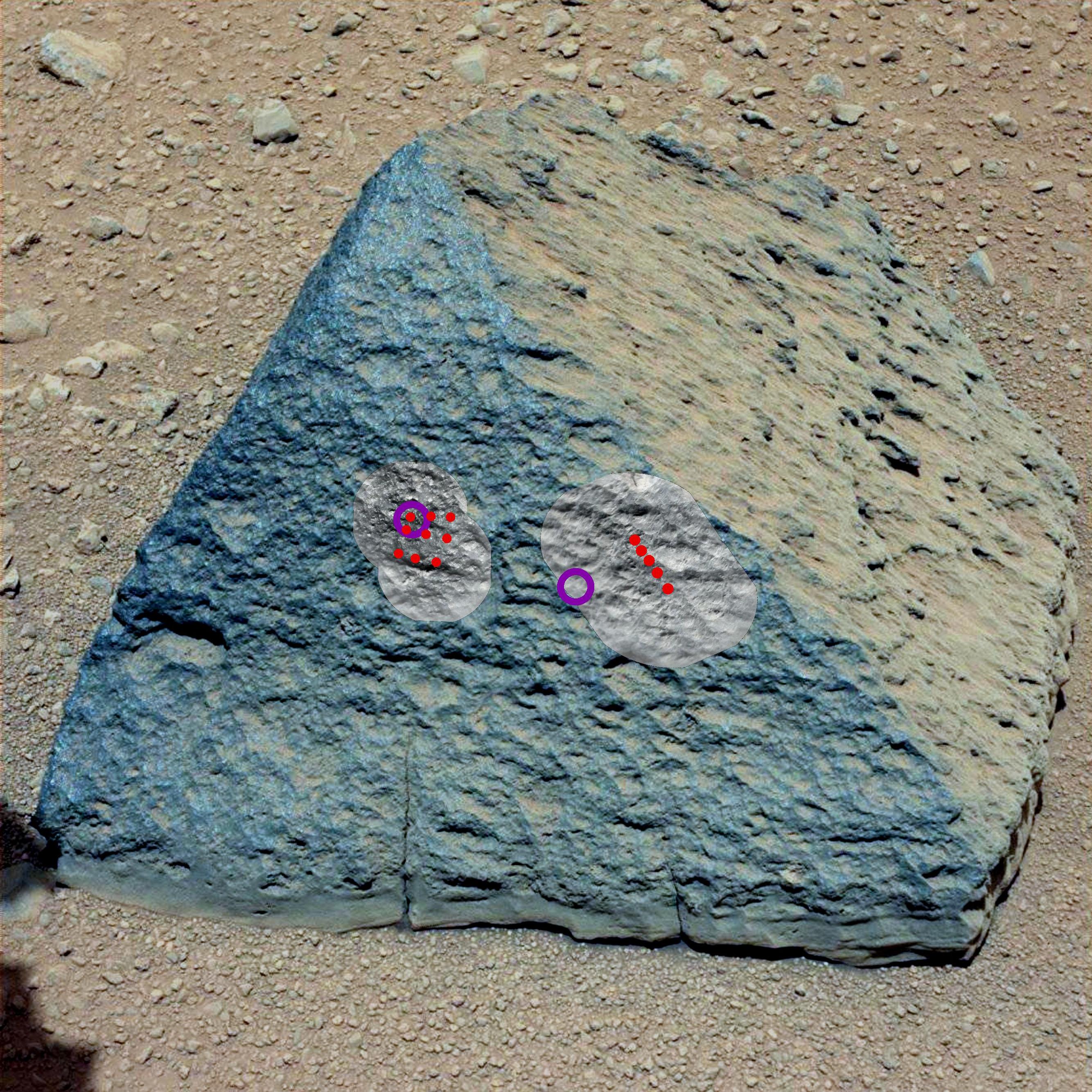
English: This image shows where NASA's Curiosity rover aimed two different instruments to study a rock known as "Jake Matijevic." The red dots are where the Chemistry and Camera (ChemCam) instrument zapped it with its laser on Sept. 21, 2012, and Sept. 24, 2012, which were the 45th and 48th sol, or Martian day of operations. The circular black and white images were taken by ChemCam to look for the pits produced by the laser. The purple circles indicate where the Alpha Particle X-ray Spectrometer trained its view.
This image was obtained by Curiosity's Mast Camera on Sept. 21, 2012 PDT (Sept. 22 UTC), or sol 46. Scientists white-balanced the color in this view to increase the inherent differences visible within the rock. Polski: Zdjęcie to, pokazuje gdzie należący do NASA łazik Curiosity skierował dwa różne instrumenty, aby studiować skałę zwaną "Jake Matijevic". Czerwone kropki wskazują punkty, w które urządzenie (ChemCAM) skierowało wiązkę lasera w dniach 21 września 2012 roku i 24 września 2012, a były to 45 i 48 sol, lub 45 i 48 dzień operacji łazika Curiosity. Purpurowe koła wskazują, gdzie Alpha Particle X-ray Spectrometer trenował praktycznie swoje operacje. Niebieski kolor skały nie jest kolorem prawdziwym, naukowcy ustawili balans bieli zdjęcia na tym poziomie, aby podkreślić i zwiększyć różnice tkwiące we wzorze skały. |
| 日期 | 2012年9月22日 UTC |
| 来源 | http://photojournal.jpl.nasa.gov/catalog/PIA16192 (direct link) |
| 作者 | NASA/JPL-Caltech/MSSS |
| 此标签不表示文件的著作权状态。任何文件在附有此标签的同時还需要一个有效的著作权标签。请参阅许可协议说明页面以了解更多信息。 其他语言:
|
许可协议
[编辑]
| 本文件完全由NASA创作,在美国属于公有领域。根据NASA的版权方针,NASA的材料除非另有声明否则不受版权保护。(参见Template:PD-USGov/zh、NASA版权方针页面或JPL图片使用方针。) | ||
 |
警告:
|
文件历史
点击某个日期/时间查看对应时刻的文件。
| 日期/时间 | 缩略图 | 大小 | 用户 | 备注 | |
|---|---|---|---|---|---|
| 当前 | 2012年10月11日 (四) 19:20 | | 2,668 × 2,668(1.07 MB) | Drbogdan(留言 | 贡献) | User created page with UploadWizard |
您不可以覆盖此文件。
文件用途
没有页面使用本文件。
全域文件用途
以下其他wiki使用此文件:
- ca.wikipedia.org上的用途
- en.wikipedia.org上的用途
- Adirondack (Mars)
- Heat Shield Rock
- Yogi Rock
- Home Plate (Mars)
- List of rocks on Mars
- Bounce Rock
- Barnacle Bill (Martian rock)
- Pot of Gold (Mars)
- El Capitan (Mars)
- Last Chance (Mars)
- Geology of Mars
- User talk:Drbogdan
- Oileán Ruaidh (Mars rock)
- Composition of Mars
- N165
- Jake Matijevic (rock)
- Bathurst Inlet (rock)
- Hottah (Mars)
- Link (Mars)
- Goulburn (Mars)
- Jacob Matijevic
- Rocknest 3
- Shelter Island meteorite
- Block Island meteorite
- Mackinac Island meteorite
- Tintina (rock)
- User:Drbogdan/sandbox-templates-Geology-MarsRocks-MoleculesInSpace
- Template:MarsRocks
- es.wikipedia.org上的用途
- fr.wikipedia.org上的用途
- hr.wikipedia.org上的用途
- pl.wikipedia.org上的用途
查看此文件的更多全域用途。