File:PIA20014-Ceres-SurveyAtlas-AsariZadeni-June2015.jpg

پروندهٔ اصلی (۱٬۹۲۹ × ۱٬۰۸۰ پیکسل، اندازهٔ پرونده: ۱٫۱۴ مگابایت، نوع MIME پرونده: image/jpeg)
گزینهها
عنوان
خلاصه
[ویرایش]
| توضیح |
English: PIA20014: Ceres Survey Atlas - June 2015
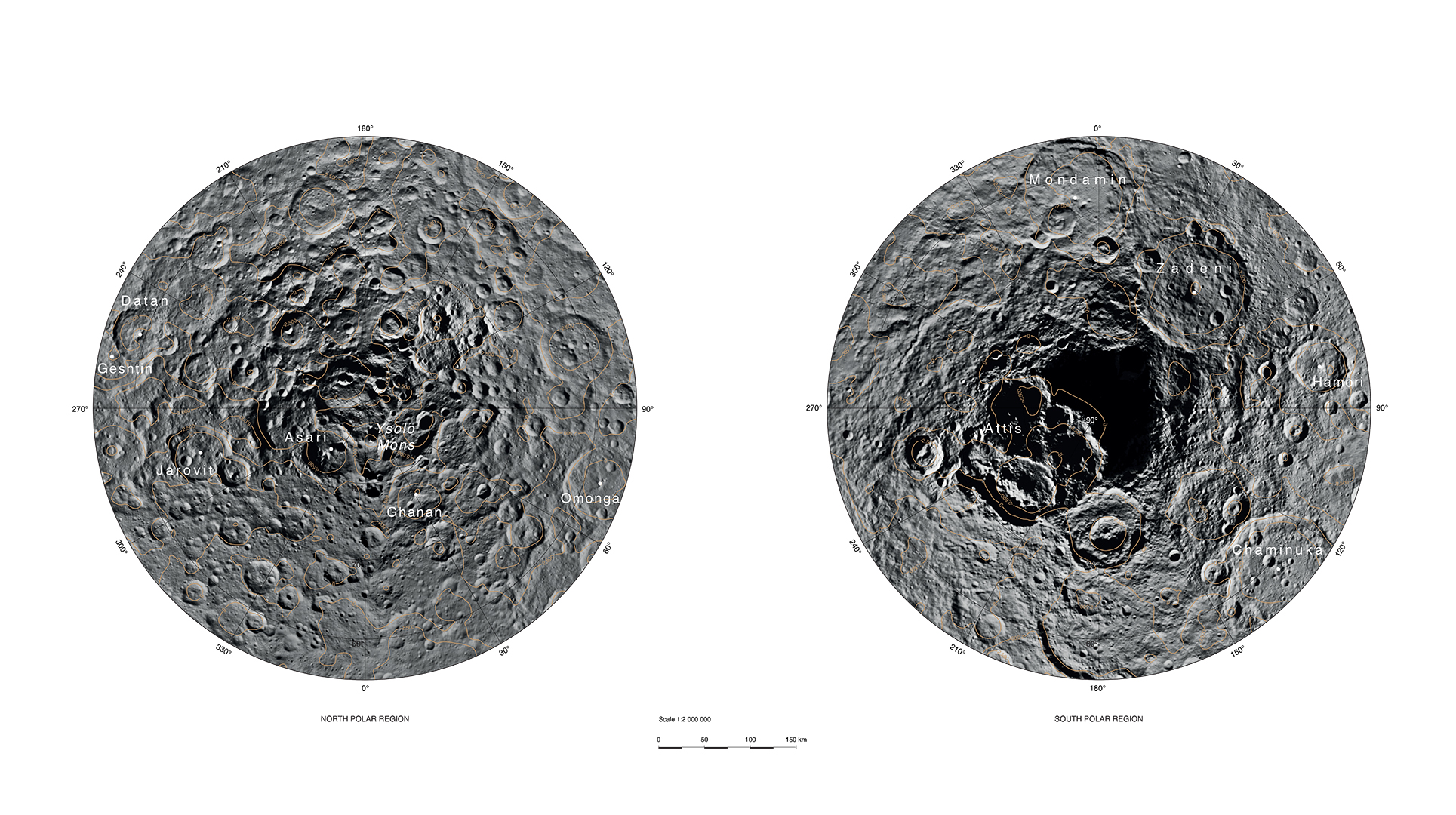
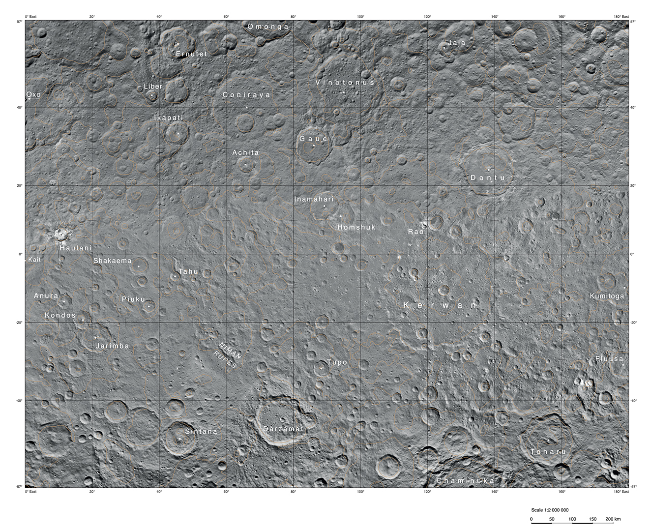
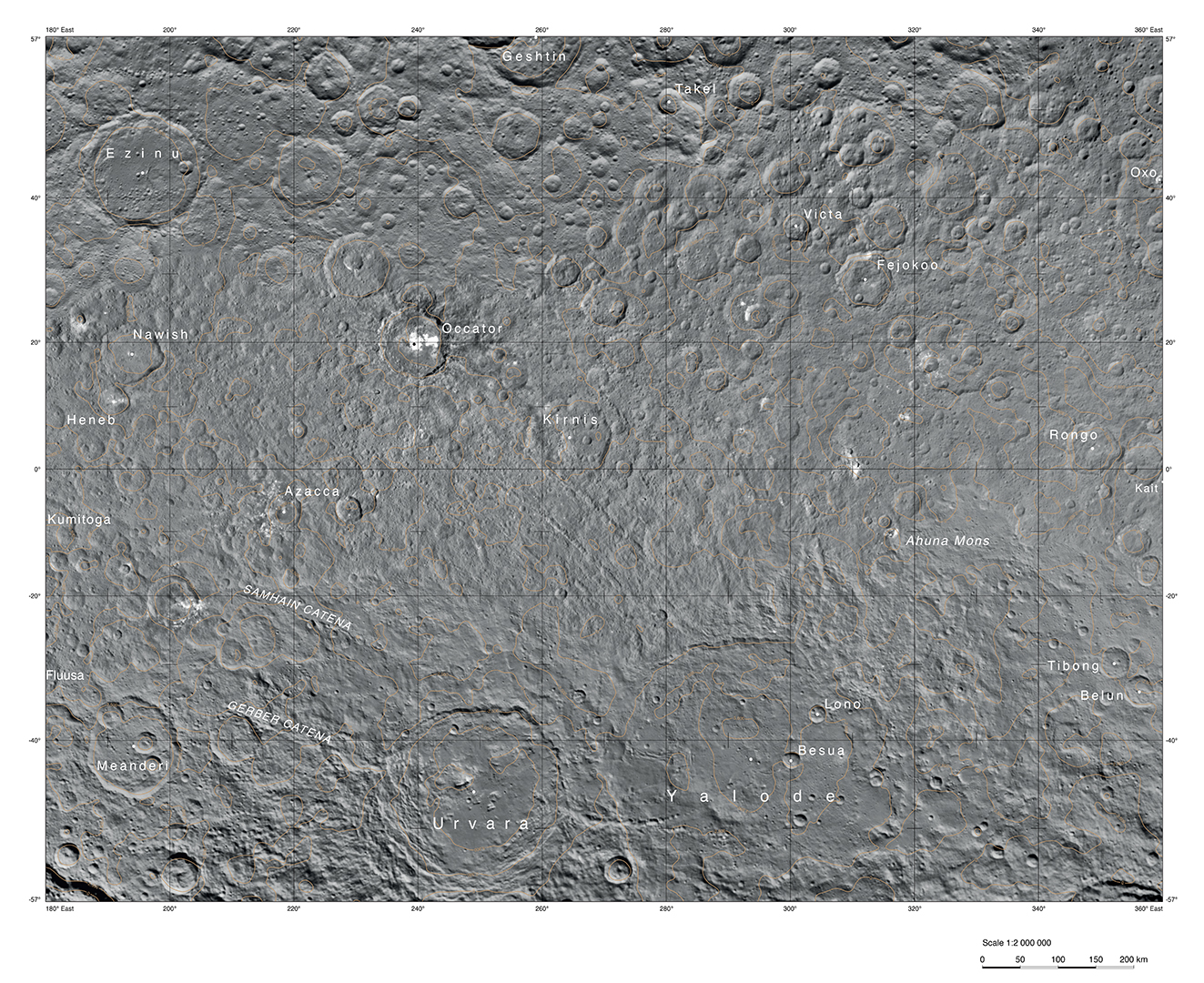
http://photojournal.jpl.nasa.gov/catalog/PIA20014 This atlas of Ceres was created using images taken by NASA's Dawn spacecraft in June 2015. Researchers used 12,000 points on Ceres to construct a terrain model, which served as the basis for these maps. Kait crater was chosen as the reference point for longitude 0. The German Aerospace Center (DLR) constructed this atlas using data from Dawn's Survey orbit, when the spacecraft was at an altitude of about 2,700 miles (4,400 kilometers) above Ceres. The resolution is approximately 1,400 feet (410 meters) per pixel in the full-resolution PDF. The Kerwan map section is centered on 0 degrees latitude, 90 east longitude. The Occator map section is centered on 0 degrees latitude, 270 east longitude. The Asari-Zadeni map section is centered above Ceres' north and south polar regions.
|
| تاریخ | |
| منبع | http://photojournal.jpl.nasa.gov/figures/PIA20014_fig1_Asari-Zadeni.jpg |
| پدیدآور | NASA/JPL-Caltech/UCLA/MPS/DLR/IDA |
اجازهنامه
[ویرایش]
| این پرونده در مالکیت عمومی قرار دارد چرا که توسط ناسا ایجاد شده است. سیاست حق تکثیر ناسا بیان میکند که «مواد ناسا با حق تکثیر محافظت نمیشوند، مگراینکه ذکر شده باشد». (Template:PD-USGov، صفحهٔ سیاست حق تکثیر ناسا یا سیاست جیپیال استفاده از تصاویر را ببینید.) | ||
 |
هشدارها:
|
تاریخچهٔ پرونده
روی تاریخ/زمانها کلیک کنید تا نسخهٔ مربوط به آن هنگام را ببینید.
| تاریخ/زمان | بندانگشتی | ابعاد | کاربر | توضیح | |
|---|---|---|---|---|---|
| کنونی | ۱ دسامبر ۲۰۱۵، ساعت ۲۱:۱۸ | | ۱٬۹۲۹ در ۱٬۰۸۰ (۱٫۱۴ مگابایت) | Drbogdan (بحث | مشارکتها) | User created page with UploadWizard |
شما نمیتوانید این پرونده را رونویسی کنید.
کاربرد پرونده
این پرونده در هیچ صفحهای به کار نرفته است.
کاربرد سراسری پرونده
ویکیهای دیگر زیر از این پرونده استفاده میکنند:
- کاربرد در en.wikipedia.org
- کاربرد در fa.wikipedia.org
- کاربرد در ja.wikipedia.org
- کاربرد در zh.wikipedia.org