File:PIA21136 Scalloped Terrain Led to Finding of Buried Ice on Mars.jpg
PIA21136_Scalloped_Terrain_Led_to_Finding_of_Buried_Ice_on_Mars.jpg (640 × 398 像素,檔案大小:57 KB,MIME 類型:image/jpeg)
說明
說明
摘要
[編輯]
| 描述 |
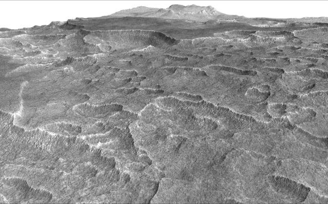
English: This vertically exaggerated view shows scalloped depressions in Mars' Utopia Planitia region, one of the area's distinctive textures that prompted researchers to check for underground ice, using ground-penetrating radar aboard NASA's Mars Reconnaissance Orbiter.
More than 600 overhead passes with the spacecraft's Shallow Radar (SHARAD) instrument provided data for determining that about as much water as the volume of Lake Superior lies in a thick layer beneath a portion of Utopia Planitia. These scalloped depressions on the surface are typically about 100 to 200 yards or meters wide. The foreground of this view covers ground about one mile (1.8 kilometers) across. The perspective view is based on a three-dimensional terrain model derived from a stereo pair of observations by the High Resolution Imaging Science Experiment (HiRISE) camera on the Mars Reconnaissance Orbiter. One was taken on Dec. 25, 2006, the other on Feb. 2, 2007. The vertical dimension is exaggerated fivefold in proportion to the horizontal dimensions, to make texture more apparent in what is a rather flat plain. Similar scalloped depressions are found in portions of the Canadian Arctic, where they are indicative of ground ice. The University of Arizona, Tucson, operates HiRISE, which was built by Ball Aerospace & Technologies Corp., Boulder, Colo. NASA's Jet Propulsion Laboratory, a division of Caltech in Pasadena, California, manages the Mars Reconnaissance Orbiter Project for NASA's Science Mission Directorate, Washington. |
| 日期 | (published 2016年十一月22日) |
| 來源 | Catalog page · Full-res (JPEG · TIFF) |
| 作者 | NASA/JPL-Caltech/Univ. of Arizona |
| 此標籤不表示文件的著作權狀態。任何文件在附有此標籤的同時還需要一個有效的著作權標籤。請參閱許可協議說明頁面以了解更多資訊。 其他語言:
|
 |
This media is a product of the Mars Reconnaissance Orbiter mission Credit and attribution belongs to the High Resolution Imaging Science Experiment (HiRISE) team, NASA/JPL-Caltech/Univ. of Arizona |
授權條款
[編輯]
| 本作品由NASA創作,屬於公有領域。根據NASA的版權政策:“NASA的創作除非另有聲明否則不受版權保護。”(參見:Template:PD-USGov/zh,NASA版權政策或JPL圖像使用政策) | ||
 |
警告:
|
檔案歷史
點選日期/時間以檢視該時間的檔案版本。
| 日期/時間 | 縮圖 | 尺寸 | 用戶 | 備註 | |
|---|---|---|---|---|---|
| 目前 | 2016年11月23日 (三) 22:05 | | 640 × 398(57 KB) | Drbogdan(對話 | 貢獻) | User created page with UploadWizard |
無法覆蓋此檔案。
檔案用途
下列2個頁面有用到此檔案:
全域檔案使用狀況
以下其他 wiki 使用了這個檔案:
- ar.wikipedia.org 的使用狀況
- bn.wikipedia.org 的使用狀況
- ca.wikipedia.org 的使用狀況
- el.wikipedia.org 的使用狀況
- en.wikipedia.org 的使用狀況
- eo.wikipedia.org 的使用狀況
- es.wikipedia.org 的使用狀況
- kk.wikipedia.org 的使用狀況
- ru.wikipedia.org 的使用狀況
- zh.wikipedia.org 的使用狀況