File:PIA21138 Location of Large Subsurface Water-Ice Deposit in Utopia Planitia, Mars.png

PIA21138_Location_of_Large_Subsurface_Water-Ice_Deposit_in_Utopia_Planitia,_Mars.png (596 × 286 像素,檔案大小:242 KB,MIME 類型:image/png)
說明
說明
摘要
[編輯]
| 描述 |
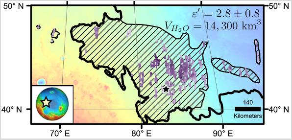
English: Diagonal striping on this map of a portion of the Utopia Planitia region on Mars indicates the area where a large subsurface deposit rich in water ice was assessed using the Shallow Radar (SHARAD) instrument on NASA's Mars Reconnaissance Orbiter.
The area is about halfway between the planet's equator and north pole, and the deposit is estimated to hold about as much water as what is in Lake Superior, largest of the Great Lakes. The scale bar at lower right indicates 140 kilometers (76 miles). The violet vertical bars show depth to the bottom of the ice-rich deposit, as estimated from SHARAD passes overhead. Darkest violet indicates a depth of about 550 feet (about 170 meters). Palest violet indicates a depth of about 33 feet (10 meters). The value of 2.8 plus-or-minus 0.8 in the upper right corner denotes the dielectric constant, a property related to radar reflectivity. The value of 14,300 cubic kilometers is an estimate of the volume of water in the deposit. SHARAD was provided by the Italian Space Agency. Its operations are led by Sapienza University of Rome, and its data are analyzed by a joint U.S.-Italian science team. The Planetary Science Institute, Tucson, Arizona, leads U.S. involvement in SHARAD. NASA's Jet Propulsion Laboratory, a division of Caltech in Pasadena, California, manages the Mars Reconnaissance Orbiter for the NASA Science Mission Directorate, Washington. Lockheed Martin Space Systems, Denver, built the orbiter and supports its operations. |
| 日期 | (published) |
| 來源 | Catalog page · Full-res (JPEG · TIFF) |
| 作者 | NASA/JPL-Caltech/Univ. of Rome/ASI/PSI |
| 此標籤不表示文件的著作權狀態。任何文件在附有此標籤的同時還需要一個有效的著作權標籤。請參閱許可協議說明頁面以了解更多資訊。 其他語言:
|
 |
This media is a product of the Mars Reconnaissance Orbiter mission Credit and attribution belongs to the Shallow Subsurface Radar (SHARAD) team, NASA/JPL-Caltech/ASI/UT |
授權條款
[編輯]
| 本作品由NASA創作,屬於公有領域。根據NASA的版權政策:“NASA的創作除非另有聲明否則不受版權保護。”(參見:Template:PD-USGov/zh,NASA版權政策或JPL圖像使用政策) | ||
 |
警告:
|
檔案歷史
點選日期/時間以檢視該時間的檔案版本。
| 日期/時間 | 縮圖 | 尺寸 | 使用者 | 備註 | |
|---|---|---|---|---|---|
| 目前 | 2016年11月24日 (四) 17:57 | | 596 × 286(242 KB) | Drbogdan(留言 | 貢獻) | User created page with UploadWizard |
無法覆蓋此檔案。
檔案用途
下列5個頁面有用到此檔案:
- Commons:WikiProject Aviation/recent uploads/2017 March 4
- File:PIA21138-Mars-UtopiaPlanitia-Map-IceFindings-20161122.png (檔案重新導向)
- File:PIA21138 - Location of Large Subsurface Water-Ice Deposit in Utopia Planitia, Mars.jpg (檔案重新導向)
- File:PIA21138 - Location of Large Subsurface Water-Ice Deposit in Utopia Planitia, Mars.png (檔案重新導向)
- File:PIA21138 Location of Large Subsurface Water-Ice Deposit in Utopia Planitia, Mars.jpg (檔案重新導向)
全域檔案使用狀況
以下其他 wiki 使用了這個檔案:
- bn.wikipedia.org 的使用狀況
- ca.wikipedia.org 的使用狀況
- el.wikipedia.org 的使用狀況
- en.wikipedia.org 的使用狀況
- es.wikipedia.org 的使用狀況
- fr.wikipedia.org 的使用狀況
- ja.wikipedia.org 的使用狀況
- ru.wikipedia.org 的使用狀況
- zh.wikipedia.org 的使用狀況