File:PIA24614-Mars-CollapsePit-20210427.jpg
原始檔案 (2,880 × 1,800 像素,檔案大小:1.18 MB,MIME 類型:image/jpeg)
說明
說明
摘要
[編輯]
| 描述 |
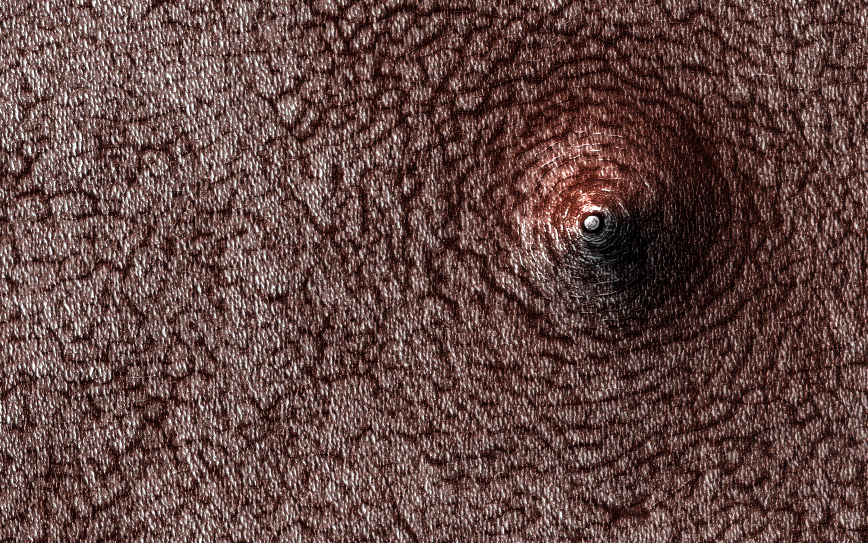
English: Mars - Collapse Pit - December 28, 2020 - uploaded April 27, 2021
PIA24614: Collapse Pit https://photojournal.jpl.nasa.gov/catalog/PIA24614 This image acquired on December 28, 2020 by NASA's Mars Reconnaissance Orbiter, shows a pit that has formed on the south polar layered deposits. Do you see a dome or a pit? Sometimes it is hard to tell! In this case, the answer is that we're looking at a pit, if the title didn't already give it away. Levity aside, we can tell this is a pit because we know what direction the sunlight is coming from and which side should be in shadow. This pit has formed on the south polar layered deposits. Why did it collapse? That is the real question to be answered. The map is projected here at a scale of 50 centimeters (19.7 inches) per pixel. (The original image scale is 49.6 centimeters [19.5 inches] per pixel [with 2 x 2 binning]; objects on the order of 149 centimeters [58.7 inches] across are resolved.) North is up. The University of Arizona, in Tucson, operates HiRISE, which was built by Ball Aerospace & Technologies Corp., in Boulder, Colorado. NASA's Jet Propulsion Laboratory, a division of Caltech in Pasadena, California, manages the Mars Reconnaissance Orbiter Project for NASA's Science Mission Directorate, Washington. |
| 日期 | |
| 來源 | https://photojournal.jpl.nasa.gov/jpeg/PIA24614.jpg |
| 作者 | NASA/JPL-Caltech/University of Arizona |
| 此標籤不表示文件的著作權狀態。任何文件在附有此標籤的同時還需要一個有效的著作權標籤。請參閱許可協議說明頁面以了解更多資訊。 其他語言:
|
授權條款
[編輯]
| 本作品由NASA創作,屬於公有領域。根據NASA的版權政策:“NASA的創作除非另有聲明否則不受版權保護。”(參見:Template:PD-USGov/zh,NASA版權政策或JPL圖像使用政策) | ||
 |
警告:
|

|
根據最有價值圖像標準,這張圖像被評定为在extraterrestrial collapse pits範疇內最有價值的共享資源圖像。你可以在Commons:Valued image candidates/PIA24614-Mars-CollapsePit-20210427.jpg参看它的提名。 |
檔案歷史
點選日期/時間以檢視該時間的檔案版本。
| 日期/時間 | 縮圖 | 尺寸 | 用戶 | 備註 | |
|---|---|---|---|---|---|
| 目前 | 2021年4月29日 (四) 11:51 | | 2,880 × 1,800(1.18 MB) | Drbogdan(對話 | 貢獻) | Uploaded a work by NASA/JPL-Caltech/University of Arizona from https://photojournal.jpl.nasa.gov/jpeg/PIA24614.jpg with UploadWizard |
無法覆蓋此檔案。
檔案用途
下列3個頁面有用到此檔案:
全域檔案使用狀況
以下其他 wiki 使用了這個檔案:
- zh.wikipedia.org 的使用狀況