File:POL powiat kartuski locator map (label-bg).svg
Jump to navigation
Jump to search

Size of this PNG preview of this SVG file: 800 × 508 pixels. Other resolutions: 320 × 203 pixels | 640 × 406 pixels | 1,024 × 650 pixels | 1,280 × 813 pixels | 2,560 × 1,626 pixels | 1,200 × 762 pixels.
Original file (SVG file, nominally 1,200 × 762 pixels, file size: 74 KB)
Captions
Captions
Add a one-line explanation of what this file represents
| Description |
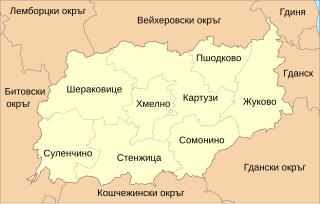
English: Labeled in polish locator map of Kartuzy County (create according to standard). Polski: Opisana po polsku mapa lokalizacyjna powiatu kartuskiego (wykonana według standardu). Български: Карта на Картузийски окръг в Полша с описание на български съгласно стандарта). |
| Date | (UTC) |
| Source | |
| Author |
|
.svg)
I, the copyright holder of this work, hereby publish it under the following licenses:
This file is licensed under the Creative Commons Attribution-Share Alike 3.0 Unported, 2.5 Generic, 2.0 Generic and 1.0 Generic license.
- You are free:
- to share – to copy, distribute and transmit the work
- to remix – to adapt the work
- Under the following conditions:
- attribution – You must give appropriate credit, provide a link to the license, and indicate if changes were made. You may do so in any reasonable manner, but not in any way that suggests the licensor endorses you or your use.
- share alike – If you remix, transform, or build upon the material, you must distribute your contributions under the same or compatible license as the original.

|
Permission is granted to copy, distribute and/or modify this document under the terms of the GNU Free Documentation License, Version 1.2 or any later version published by the Free Software Foundation; with no Invariant Sections, no Front-Cover Texts, and no Back-Cover Texts. A copy of the license is included in the section entitled GNU Free Documentation License. |
You may select the license of your choice.
Original upload log
[edit].svg&action=edit§ion=1)
This image is a derivative work of the following images:
- File:POL_powiat_kartuski_locator_map_(label-pl).svg licensed with Cc-by-sa-3.0,2.5,2.0,1.0, GFDL
- 2009-07-31T14:37:08Z Magul 1200x762 (68073 Bytes) usunięte obszary miejskie
- 2009-07-31T11:00:04Z Magul 1200x762 (71110 Bytes) == Opis == {{Information |Description={{en|1=Labeled in polish locator map of Kartuzy County (create according to [http://en.wikipedia.org/wiki/Wikipedia:WikiProject_Maps/Conventions/Locator_maps_(blank) standard]).}} {{pl|1=
Uploaded with derivativeFX
File history
Click on a date/time to view the file as it appeared at that time.
| Date/Time | Thumbnail | Dimensions | User | Comment | |
|---|---|---|---|---|---|
| current | 12:33, 29 November 2010 | | 1,200 × 762 (74 KB) | BloodIce (talk | contribs) | Fixed problem with a layer. |
| 12:33, 29 November 2010 |  | 1,200 × 762 (74 KB) | BloodIce (talk | contribs) | Fixed problem with a layer. | |
| 12:20, 29 November 2010 |  | 1,200 × 762 (74 KB) | BloodIce (talk | contribs) | {{Information |Description={{en|1=Labeled in polish locator map of Kartuzy County (create according to [http://en.wikipedia.org/wiki/Wikipedia:WikiProject_Maps/Conventions/Locator_maps_(blank) standard]).}} {{pl|1=Opisana po polsku mapa lokalizacyjna powi |
You cannot overwrite this file.
File usage on Commons
There are no pages that use this file.
File usage on other wikis
The following other wikis use this file:
- Usage on bg.wikipedia.org
.svg&oldid=486014999)