File:Pacific Area - The Imperial Powers 1939 - Map-es.svg
Ir a la navegación
Ir a la búsqueda

Tamaño de esta previsualización PNG del archivo SVG: 765 × 599 píxeles. Otras resoluciones: 306 × 240 píxeles | 613 × 480 píxeles | 980 × 768 píxeles | 1280 × 1003 píxeles | 2560 × 2006 píxeles | 1039 × 814 píxeles.
Archivo original (archivo SVG, nominalmente 1039 × 814 píxeles, tamaño de archivo: 2,89 MB)
Leyendas
Leyendas
Añade una explicación corta acerca de lo que representa este archivo
Resumen
[editar]| Descripción |
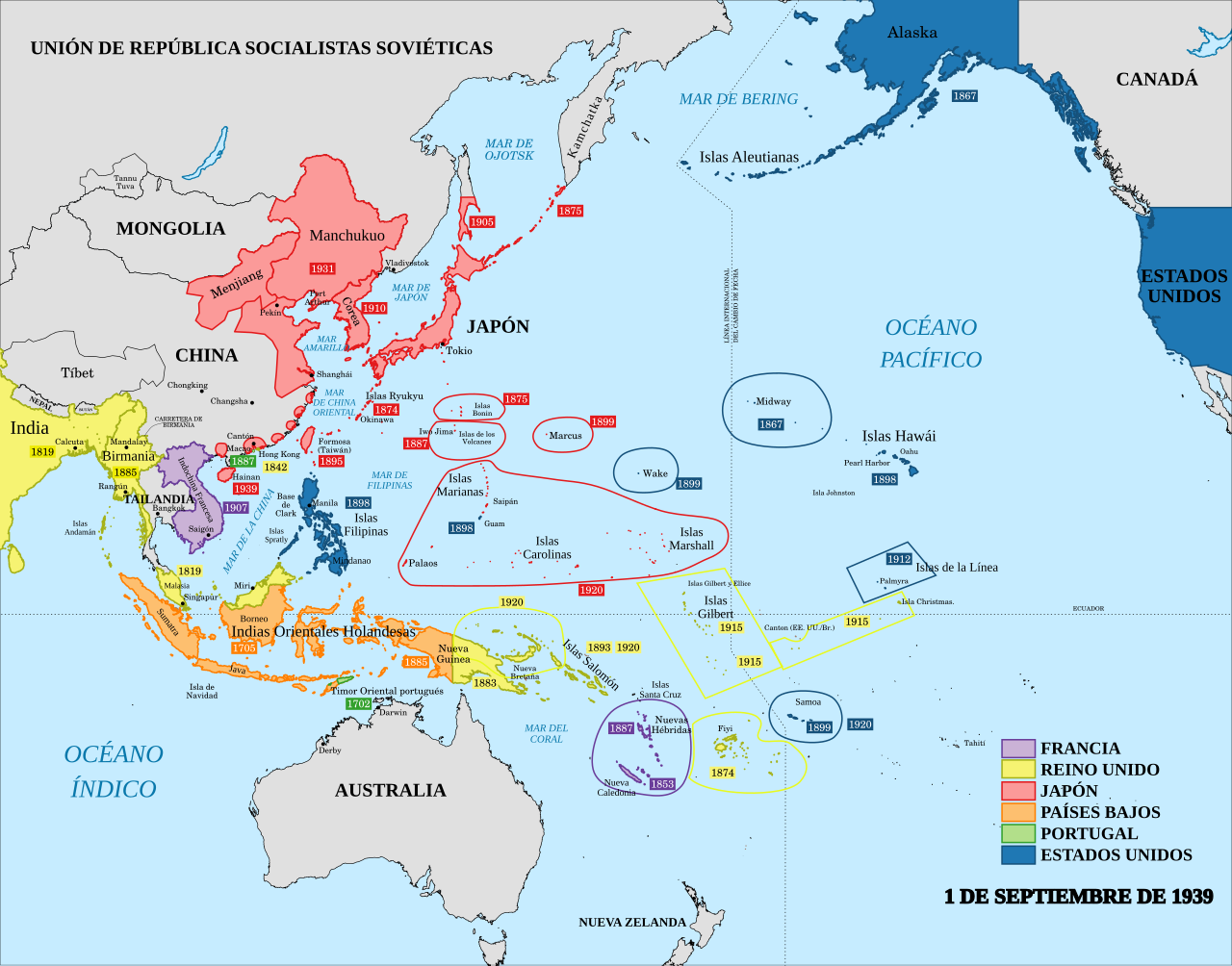
English: A map of the Imperial Powers of the Pacific, 1939-09-01. Dates shown indicate the approximate year that the various powers gain control of their possessions. Japanese control of territory in China was tenuous. Español: Las colonias del Pacífico el 1 de septiembre de 1939. |
| Fecha | |
| Fuente |
Este archivo deriva de: Pacific Area - The Imperial Powers 1939 - Map.svg : Emok |
| Autor |
|
| Otras versiones |
[]
|


Licencia
[editar]
Yo, el titular de los derechos de autor de esta obra, la publico en los términos de la siguiente licencia:
Este archivo está disponible bajo la licencia Creative Commons Attribution-Share Alike 4.0 International.
- Eres libre:
- de compartir – de copiar, distribuir y transmitir el trabajo
- de remezclar – de adaptar el trabajo
- Bajo las siguientes condiciones:
- atribución – Debes otorgar el crédito correspondiente, proporcionar un enlace a la licencia e indicar si realizaste algún cambio. Puedes hacerlo de cualquier manera razonable pero no de manera que sugiera que el licenciante te respalda a ti o al uso que hagas del trabajo.
- compartir igual – En caso de mezclar, transformar o modificar este trabajo, deberás distribuir el trabajo resultante bajo la misma licencia o una compatible como el original.
Historial del archivo
Haz clic sobre una fecha y hora para ver el archivo tal como apareció en ese momento.
| Fecha y hora | Miniatura | Dimensiones | Usuario | Comentario | |
|---|---|---|---|---|---|
| actual | 16:06 26 mar 2020 | | 1039 × 814 (2,89 MB) | Rowanwindwhistler (discusión | contribs.) | Several changes and corrections. Fake text added. |
| 20:39 18 jul 2014 |  | 1039 × 814 (4,44 MB) | Rowanwindwhistler (discusión | contribs.) | User created page with UploadWizard |
No puedes sobrescribir este archivo.
Usos del archivo
Las siguientes páginas usan este archivo:
- User:Magog the Ogre/Maps of conflicts/2014 July
- User:Magog the Ogre/Maps of conflicts/2020 March
- User:Magog the Ogre/Multilingual legend/2020 March 21-31
- File:Kolonialmächte im Pazifikraum, 1939.svg
- File:Pacific Area - Imperial Powers 1939 - Map.svg
- File:Pacific Area - The Imperial Powers 1939 - Map-es.svg
- File:Pacific Area - The Imperial Powers 1939 - Map-hu.svg
- File:Pacific Area - The Imperial Powers 1939 - Map-it.svg
- File:Pacific Area - The Imperial Powers 1939 - Map.svg
- File:Pacific Area - The Imperial Powers 1939 - Map mk.svg
- Template:Other versions/Pacific Area - The Imperial Powers 1939
Uso global del archivo
Las wikis siguientes utilizan este archivo:
- Uso en ast.wikipedia.org
- Uso en ca.wikipedia.org
- Uso en es.wikipedia.org
Metadatos
Categorías:
- Spanish-language SVG maps showing history
- Maps of the history of Oceania
- Maps showing the history of colonies
- Maps of World War II in the Pacific
- Maps of the Empire of Japan
- Maps of former colonies of the United Kingdom in Oceania
- Maps of former colonies of the United Kingdom in Asia
- Maps of former colonies of Portugal in Asia
- SVG maps of Portugal