File:Pacific Ring of Fire.png
跳转到导航
跳转到搜索
本预览的尺寸:800 × 593像素。 其他分辨率:320 × 237像素 | 640 × 475像素 | 1,024 × 760像素 | 1,046 × 776像素。
原始文件 (1,046 × 776像素,文件大小:66 KB,MIME类型:image/png)
说明
说明
添加一行文字以描述该文件所表现的内容

|
File:Pacific Ring of Fire.svg是此文件的矢量版本。 应当将此点阵图片替换为该文件。
File:Pacific Ring of Fire.png → File:Pacific Ring of Fire.svg
更多信息请参阅Help:SVG/zh。 |
 |
摘要
[编辑]
| 描述 |
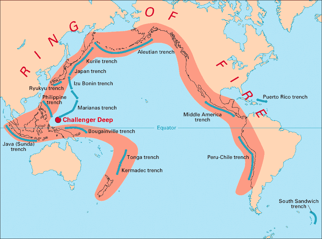
English: Volcanic arcs and oceanic trenches partly encircling the Pacific Basin form the so-called Pacific Ring of fire, a zone of frequent earthquakes and volcanic eruptions. The trenches are shown in blue-green. The volcanic island arcs, although not labelled, are parallel to, and always landward of, the trenches. For example, the island arc associated with the Aleutian Trench is represented by the long chain of volcanoes that make up the Aleutian Islands. |
| 日期 | |
| 来源 | http://pubs.usgs.gov/publications/text/fire.html |
| 作者 | USGS |
许可协议
[编辑]
|
|
文件历史
点击某个日期/时间查看对应时刻的文件。
| 日期/时间 | 缩略图 | 大小 | 用户 | 备注 | |
|---|---|---|---|---|---|
| 当前 | 2004年12月28日 (二) 03:28 | | 1,046 × 776(66 KB) | Ævar Arnfjörð Bjarmason(留言 | 贡献) | Deeper colours |
| 2004年12月28日 (二) 03:26 |  | 1,046 × 776(156 KB) | Ævar Arnfjörð Bjarmason(留言 | 贡献) |
您不可以覆盖此文件。
文件用途
以下页面使用本文件:
全域文件用途
以下其他wiki使用此文件:
- als.wikipedia.org上的用途
- ar.wikipedia.org上的用途
- ary.wikipedia.org上的用途
- bs.wikipedia.org上的用途
- ca.wikipedia.org上的用途
- da.wikipedia.org上的用途
- dsb.wikipedia.org上的用途
- en.wikipedia.org上的用途
- en.wikibooks.org上的用途
- eo.wikipedia.org上的用途
- eu.wikipedia.org上的用途
- fr.wikipedia.org上的用途
- gl.wikipedia.org上的用途
- hr.wikipedia.org上的用途
- hsb.wikipedia.org上的用途
- id.wikipedia.org上的用途
- it.wikipedia.org上的用途
- ko.wikipedia.org上的用途
- ko.wikinews.org上的用途
- lt.wikipedia.org上的用途
- lv.wikipedia.org上的用途
- mg.wikipedia.org上的用途
- ms.wikipedia.org上的用途
- nia.wikipedia.org上的用途
- nl.wikipedia.org上的用途
- nn.wikipedia.org上的用途
- no.wikipedia.org上的用途
- pap.wikipedia.org上的用途
- pnb.wikipedia.org上的用途
- ro.wikipedia.org上的用途
- simple.wikipedia.org上的用途
- sk.wikipedia.org上的用途
- sl.wikipedia.org上的用途
- sr.wikipedia.org上的用途
- su.wikipedia.org上的用途
- sv.wikipedia.org上的用途
查看此文件的更多全域用途。