File:Pakistan NWFP FATA NORTH WAZIRISTAN.svg
跳转到导航
跳转到搜索

此SVG文件的PNG预览的大小:558 × 600像素。 其他分辨率:223 × 240像素 | 446 × 480像素 | 714 × 768像素 | 953 × 1,024像素 | 1,905 × 2,048像素 | 1,000 × 1,075像素。
原始文件 (SVG文件,尺寸为1,000 × 1,075像素,文件大小:202 KB)
说明
说明
添加一行文字以描述该文件所表现的内容
| 描述 |
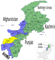
English: Map showing the districts of the Federally Administered Tribal Areas (FATA) FATA and the North-West Frontier Province (NWFP) of Pakistan. Español: Mapa de las provincias y territorios de Pakistán Français : Carte des régions tribales du Pakistan (FATA) et de la province voisine de Khyber Pakhtunkhwa (KPK) |
| 日期 | (UTC) |
| 来源 | |
| 作者 |
|
| 这是一张修改过的图片,这意味着它已在原版本的基础上通过软件进行了编辑。其原始版本为:Pakistan NWFP FATA areas with localisation map.svg。
|
我,本作品著作权人,特此采用以下许可协议发表本作品:
- 您可以自由地:
- 共享 – 复制、发行并传播本作品
- 修改 – 改编作品
- 惟须遵守下列条件:
- 署名 – 您必须对作品进行署名,提供授权条款的链接,并说明是否对原始内容进行了更改。您可以用任何合理的方式来署名,但不得以任何方式表明许可人认可您或您的使用。
- 相同方式共享 – 如果您再混合、转换或者基于本作品进行创作,您必须以与原先许可协议相同或相兼容的许可协议分发您贡献的作品。
| 本文件采用知识共享署名-相同方式共享 3.0 未本地化版本许可协议授权。 | ||
| ||
| 本许可协议标签作为GFDL许可协议更新的组成部分被添加至本文件。 |

|
已授权您依据自由软件基金会发行的无固定段落及封面封底文字(Invariant Sections, Front-Cover Texts, and Back-Cover Texts)的GNU自由文件许可协议1.2版或任意后续版本的条款,复制、传播和/或修改本文件。该协议的副本请见“GNU Free Documentation License”。 |
您可以选择您需要的许可协议。
原始上传日志[编辑]
This image is a derivative work of the following images:
- File:Pakistan_NWFP_FATA_areas_with_localisation_map.svg licensed with Cc-by-sa-2.5,2.0,1.0, Cc-by-sa-3.0-migrated, GFDL
- 2010-05-16T19:22:19Z Pethrus 1000x1075 (248950 Bytes) Added district borders
- 2010-05-16T11:13:01Z Pethrus 1000x1075 (243431 Bytes) Corrected NWFP -> KPK name, added blue districts borders
- 2010-05-15T16:55:47Z Pethrus 1000x1075 (236350 Bytes) {{Information |Description={{en|Map showing the districts of the Federally Administered Tribal Areas (FATA) FATA and the North-West Frontier Province (NWFP) of Pakistan.}} {{es|Mapa de las provincias y territorios de Pakistá
Uploaded with derivativeFX
文件历史
点击某个日期/时间查看对应时刻的文件。
| 日期/时间 | 缩略图 | 大小 | 用户 | 备注 | |
|---|---|---|---|---|---|
| 当前 | 2010年7月11日 (日) 15:39 | | 1,000 × 1,075(202 KB) | Guillaume70(留言 | 贡献) | {{Information |Description={{en|Map showing the districts of the Federally Administered Tribal Areas (FATA) FATA and the North-West Frontier Province (NWFP) of Pakistan.}} {{es|Mapa de las provincias y territorios de Pakistán}} {{fr|Carte des [[:fr:Régi |
您不可以覆盖此文件。
文件用途
没有页面使用本文件。
全域文件用途
以下其他wiki使用此文件:
- ar.wikipedia.org上的用途
- en.wikipedia.org上的用途
- fr.wikipedia.org上的用途
- fr.wikinews.org上的用途
- hi.wikipedia.org上的用途
- nl.wikipedia.org上的用途
- pl.wikipedia.org上的用途
- pt.wikipedia.org上的用途
- ru.wikipedia.org上的用途
- ru.wikinews.org上的用途
- ta.wikipedia.org上的用途
- uk.wikipedia.org上的用途
- zh.wikipedia.org上的用途