File:Pakistan NWFP FATA NORTH WAZIRISTAN.svg
跳至導覽
跳至搜尋

此 SVG 檔案的 PNG 預覽的大小:558 × 600 像素。 其他解析度:223 × 240 像素 | 446 × 480 像素 | 714 × 768 像素 | 953 × 1,024 像素 | 1,905 × 2,048 像素 | 1,000 × 1,075 像素。
原始檔案 (SVG 檔案,表面大小:1,000 × 1,075 像素,檔案大小:202 KB)
說明
說明
添加單行說明來描述出檔案所代表的內容
| 描述 |
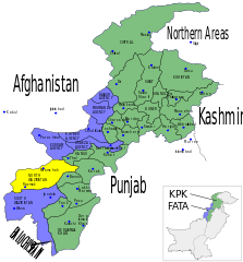
English: Map showing the districts of the Federally Administered Tribal Areas (FATA) FATA and the North-West Frontier Province (NWFP) of Pakistan. Español: Mapa de las provincias y territorios de Pakistán Français : Carte des régions tribales du Pakistan (FATA) et de la province voisine de Khyber Pakhtunkhwa (KPK) |
| 日期 | (UTC) |
| 來源 | |
| 作者 |
|
| 這是一張修飾過的圖片,即本圖片是用軟體修改過後的版本。原版圖片來源:Pakistan NWFP FATA areas with localisation map.svg。
|
我,本作品的著作權持有者,決定用以下授權條款發佈本作品:
| 此檔案採用共享創意 姓名標示-相同方式分享 3.0 未在地化版本授權條款。 | ||
| ||
| 已新增授權條款標題至此檔案,作為GFDL授權更新的一部份。 |

|
已授權您依據自由軟體基金會發行的無固定段落、封面文字和封底文字GNU自由文件授權條款1.2版或任意後續版本,對本檔進行複製、傳播和/或修改。該協議的副本列在GNU自由文件授權條款中。 |
您可以選擇您需要的授權條款。
原始上傳日誌
[編輯]
This image is a derivative work of the following images:
- File:Pakistan_NWFP_FATA_areas_with_localisation_map.svg licensed with Cc-by-sa-2.5,2.0,1.0, Cc-by-sa-3.0-migrated, GFDL
- 2010-05-16T19:22:19Z Pethrus 1000x1075 (248950 Bytes) Added district borders
- 2010-05-16T11:13:01Z Pethrus 1000x1075 (243431 Bytes) Corrected NWFP -> KPK name, added blue districts borders
- 2010-05-15T16:55:47Z Pethrus 1000x1075 (236350 Bytes) {{Information |Description={{en|Map showing the districts of the Federally Administered Tribal Areas (FATA) FATA and the North-West Frontier Province (NWFP) of Pakistan.}} {{es|Mapa de las provincias y territorios de Pakistá
Uploaded with derivativeFX
檔案歷史
點選日期/時間以檢視該時間的檔案版本。
| 日期/時間 | 縮圖 | 尺寸 | 用戶 | 備註 | |
|---|---|---|---|---|---|
| 目前 | 2010年7月11日 (日) 15:39 | | 1,000 × 1,075(202 KB) | Guillaume70(對話 | 貢獻) | {{Information |Description={{en|Map showing the districts of the Federally Administered Tribal Areas (FATA) FATA and the North-West Frontier Province (NWFP) of Pakistan.}} {{es|Mapa de las provincias y territorios de Pakistán}} {{fr|Carte des [[:fr:Régi |
無法覆蓋此檔案。
檔案用途
沒有使用此檔案的頁面。
全域檔案使用狀況
以下其他 wiki 使用了這個檔案:
- ar.wikipedia.org 的使用狀況
- en.wikipedia.org 的使用狀況
- fr.wikipedia.org 的使用狀況
- fr.wikinews.org 的使用狀況
- hi.wikipedia.org 的使用狀況
- nl.wikipedia.org 的使用狀況
- pl.wikipedia.org 的使用狀況
- pt.wikipedia.org 的使用狀況
- ru.wikipedia.org 的使用狀況
- ru.wikinews.org 的使用狀況
- ta.wikipedia.org 的使用狀況
- uk.wikipedia.org 的使用狀況
- zh.wikipedia.org 的使用狀況