File:Paktopo de.jpg
Jump to navigation
Jump to search
Size of this preview: 646 × 600 pixels. Other resolutions: 259 × 240 pixels | 517 × 480 pixels | 827 × 768 pixels | 1,187 × 1,102 pixels.
Original file (1,187 × 1,102 pixels, file size: 1.28 MB, MIME type: image/jpeg)
Captions
Captions
Add a one-line explanation of what this file represents
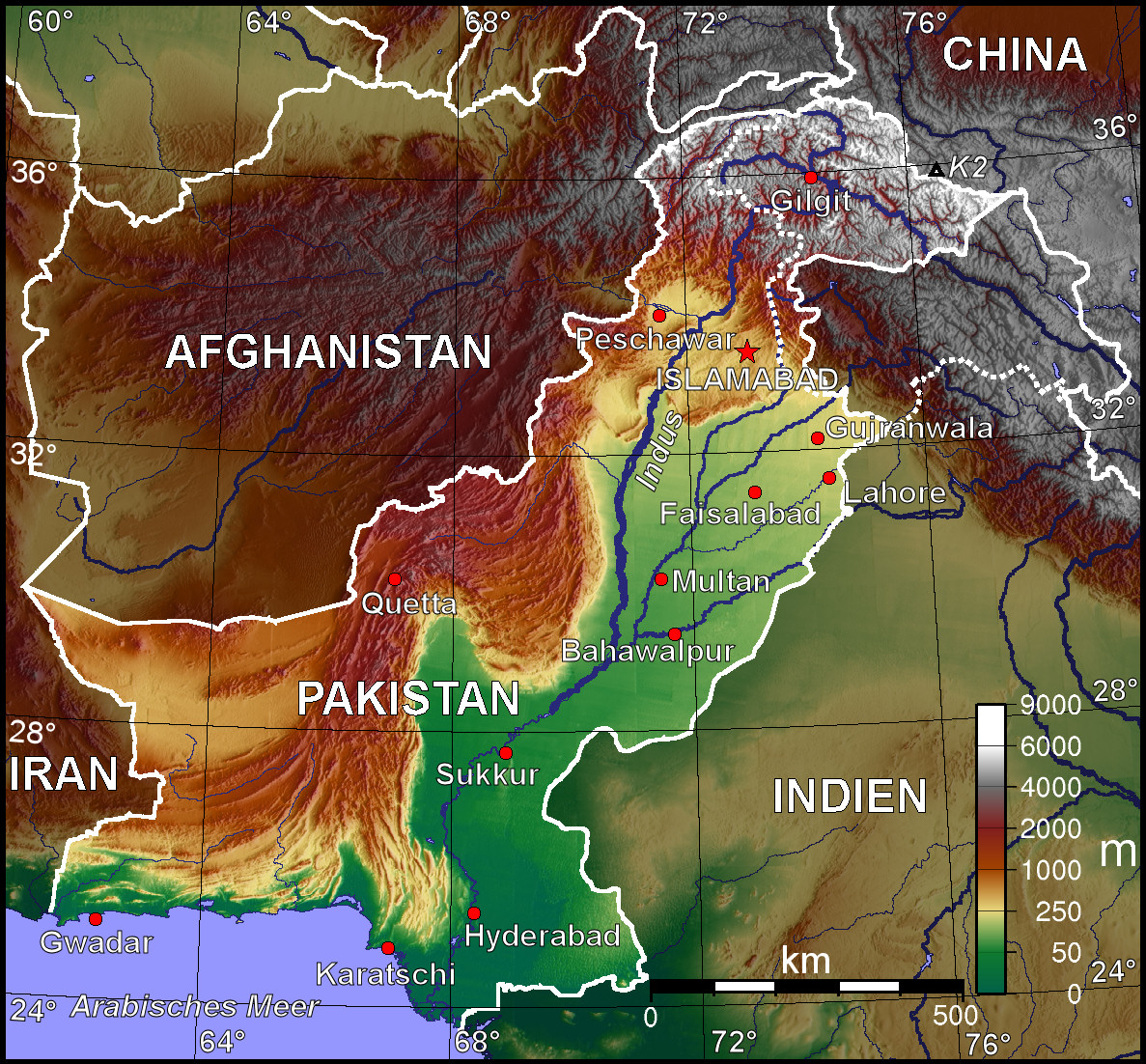
| Description | Topografische Karte Pakistans (deutschsprachige Version) |
| Date | |
| Source | Selbst erstellt mit Generic Mapping Tool |
| Author | BishkekRocks |
| Permission (Reusing this file) |
Unter GNU-FDL veröffentlicht |
| Other versions | Other language versions available upon request |
The map has been created with the Generic Mapping Tools: https://www.generic-mapping-tools.org/ using one or more of these public-domain datasets for the relief:
|

|
Permission is granted to copy, distribute and/or modify this document under the terms of the GNU Free Documentation License, Version 1.2 or any later version published by the Free Software Foundation; with no Invariant Sections, no Front-Cover Texts, and no Back-Cover Texts. A copy of the license is included in the section entitled GNU Free Documentation License. |
| This file is licensed under the Creative Commons Attribution-Share Alike 3.0 Unported license. | ||
| ||
| This licensing tag was added to this file as part of the GFDL licensing update. |
File history
Click on a date/time to view the file as it appeared at that time.
| Date/Time | Thumbnail | Dimensions | User | Comment | |
|---|---|---|---|---|---|
| current | 16:38, 11 October 2006 | | 1,187 × 1,102 (1.28 MB) | Jungpionier (talk | contribs) | besser so |
| 15:47, 11 October 2006 |  | 1,187 × 1,102 (307 KB) | Jungpionier (talk | contribs) | ein winziges kleines bisschen nachbearbeitet (rote Punkte außerhalb der Stadtmarkierungspunkte entfernt) | |
| 13:20, 11 October 2006 |  | 1,187 × 1,102 (684 KB) | BishkekRocks (talk | contribs) | {{Information |Description=Topografische Karte Pakistans (deutschsprachige Version) |Source=Selbst erstellt mit Generic Mapping Tool |Date=11. Oktober 2006 |Author=BishkekRocks |Permission=Unter GNU-FDL veröffentlicht }} {{GMT}} [[C |
You cannot overwrite this file.
File usage
The following 4 pages use this file:
Global file usage
The following other wikis use this file:
- Usage on ace.wikipedia.org
- Usage on azb.wikipedia.org
- Usage on az.wikipedia.org
- Usage on be.wikipedia.org
- Usage on bg.wikipedia.org
- Usage on bs.wikipedia.org
- Usage on ca.wikipedia.org
- Usage on de.wikipedia.org
- Usage on diq.wikipedia.org
- Usage on en.wikipedia.org
- Usage on es.wikipedia.org
- Usage on fiu-vro.wikipedia.org
- Usage on frr.wikipedia.org
- Usage on fr.wikipedia.org
- Usage on hif.wikipedia.org
- Usage on hr.wikipedia.org
- Usage on incubator.wikimedia.org
- Usage on it.wikipedia.org
- Usage on kk.wikipedia.org
- Usage on lv.wikipedia.org
- Usage on pl.wikipedia.org
- Usage on pnb.wikipedia.org
- Usage on sd.wikipedia.org
- Usage on sh.wikipedia.org
- Usage on tr.wikipedia.org
- Usage on uk.wikipedia.org
- Usage on ur.wikipedia.org