File:Paleografische kaart 800nC detail.png
Jump to navigation
Jump to search

Size of this preview: 800 × 450 pixels. Other resolutions: 320 × 180 pixels | 640 × 360 pixels | 1,024 × 576 pixels | 1,280 × 720 pixels | 1,920 × 1,080 pixels.
Original file (1,920 × 1,080 pixels, file size: 434 KB, MIME type: image/png)
Captions
Captions
Add a one-line explanation of what this file represents
Summary[edit]
| Description |
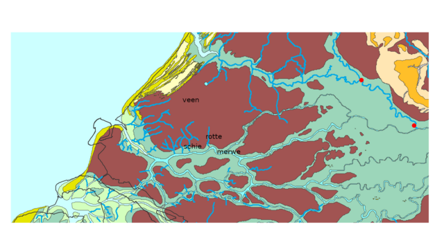
Nederlands: Paleografische kaart 800na Chr detail met Delfland/Schieland |
| Date | |
| Source | Vos, P., M. van der Meulen, H. Weerts en J. Bazelmans 2018: Atlas van Nederland in het Holoceen. Landschap en bewoning vanaf de laatste ijstijd tot nu, Amsterdam (Prometheus). |
| Author | Vos, P., M. van der Meulen, H. Weerts en J. Bazelmans |
Licensing[edit]
This file is licensed under the Creative Commons Attribution-Share Alike 4.0 International license.
- You are free:
- to share – to copy, distribute and transmit the work
- to remix – to adapt the work
- Under the following conditions:
- attribution – You must give appropriate credit, provide a link to the license, and indicate if changes were made. You may do so in any reasonable manner, but not in any way that suggests the licensor endorses you or your use.
- share alike – If you remix, transform, or build upon the material, you must distribute your contributions under the same or compatible license as the original.
File history
Click on a date/time to view the file as it appeared at that time.
| Date/Time | Thumbnail | Dimensions | User | Comment | |
|---|---|---|---|---|---|
| current | 13:48, 22 October 2020 | | 1,920 × 1,080 (434 KB) | RoBes81 (talk | contribs) | Uploaded a work by Vos, P., M. van der Meulen, H. Weerts en J. Bazelmans from Vos, P., M. van der Meulen, H. Weerts en J. Bazelmans 2018: Atlas van Nederland in het Holoceen. Landschap en bewoning vanaf de laatste ijstijd tot nu, Amsterdam (Prometheus). with UploadWizard |
You cannot overwrite this file.
File usage on Commons
There are no pages that use this file.
File usage on other wikis
The following other wikis use this file:
- Usage on nl.wikipedia.org