File:Palestinian authority map text.gif
Spring til navigation
Spring til søgning

Størrelse af denne forhåndsvisning: 183 × 597 pixels. Andre opløsninger: 73 × 240 pixels | 326 × 1.064 pixels.
Oprindelig fil (326 × 1.064 billedpunkter, filstørrelse: 25 KB, MIME-type: image/gif)
Captions
Captions
Tilføj en kort forklaring på en enkelt linje om hvad filen viser
|

|
Dette billede (eller alle billederne i denne artikel eller kategori) bør genskabes ved hjælp af vektorgrafik som en SVG-fil. Dette har flere fordele; se Commons:Media for cleanup for mere information. Hvis der eksisterer en SVG-version af dette billede, så vær venlig at lægge den op. Efter en SVG-version er blevet lagt op, så erstat denne skabelon med {{Vector version available|nyt billedes navn.svg}} på denne side.
|
Beskrivelse
[redigér]
| Beskrivelse |
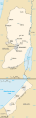
English: Map of West Bank and Gaza Strip |
| Dato | |
| Kilde | CIA World Factbook 2006 (from the West Bank and Gaza Strip entries) |
| Forfatter | CIA |
| Tilladelse (Genbrug af denne fil) |
Public Domain as described in https://www.cia.gov/cia/publications/factbook/docs/contributor_copyright.html |
| Andre versioner | Palestinian_authority_map.gif |
Licensering
[redigér]
This image is in the public domain because it contains materials that originally came from the United States Central Intelligence Agency's World Factbook.
|
 |
Licensering
[redigér]
This image is in the public domain because it contains materials that originally came from the United States Central Intelligence Agency's World Factbook.
|
|
| Annotations | This image is annotated: View the annotations at Commons |
Filhistorik
Klik på en dato/tid for at se filen som den så ud på det tidspunkt.
| Dato/tid | Miniaturebillede | Dimensioner | Bruger | Kommentar | |
|---|---|---|---|---|---|
| nuværende | 1. maj 2011, 19:15 | 326 × 1.064 (25 KB) | Ras67 (diskussion | bidrag) | cropped | |
| 24. aug. 2008, 00:19 | 330 × 1.069 (27 KB) | Koavf (diskussion | bidrag) | {{Information |Description={{en|1=Map of West Bank and Gaza Strip}} |Source=CIA World Factbook 2006 (from the West Bank and Gaza Strip entries) |Author=CIA |Date=2006 |Permission=Public Domain as described in https://www.cia.gov/cia/publications/factbook/ |
Du kan ikke overskrive denne fil.
Filanvendelse
Der er ingen sider der bruger denne fil.
Global filanvendelse
Følgende andre wikier anvender denne fil:
- Anvendelser på an.wikipedia.org
- Anvendelser på ast.wikipedia.org
- Anvendelser på da.wikipedia.org
- Anvendelser på es.wikipedia.org
- Anvendelser på gl.wikipedia.org
- Anvendelser på incubator.wikimedia.org
- Anvendelser på pnb.wikipedia.org
- Anvendelser på ro.wikipedia.org
- Anvendelser på sv.wikipedia.org
- Anvendelser på vi.wikipedia.org