File:Palms Annexation Map.gif
Jump to navigation
Jump to search
Size of this preview: 800 × 469 pixels. Other resolutions: 320 × 187 pixels | 640 × 375 pixels | 821 × 481 pixels.
Original file (821 × 481 pixels, file size: 118 KB, MIME type: image/gif)
Captions
Captions
Add a one-line explanation of what this file represents
Summary[edit]
| Description |
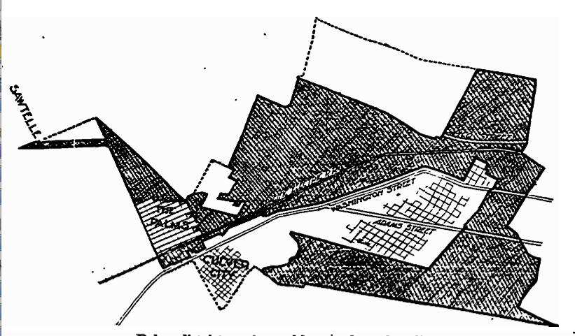
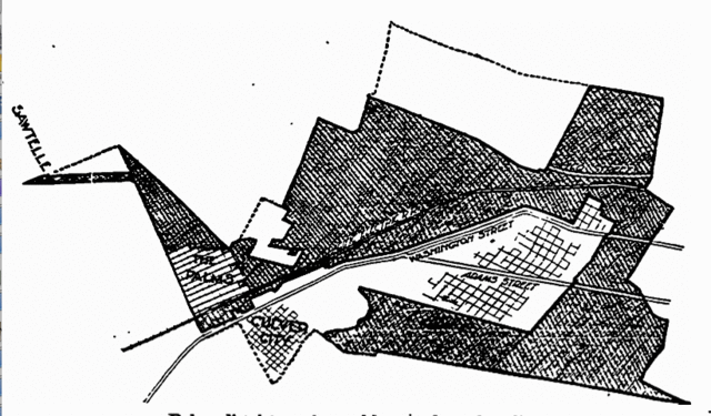
English: Map printed in Los Angeles Times of May 24, 1914 (copyright expired). "Palms district as changed by new boundary lines. The shaded portions indicate the region which it is now proposed to annex to Los Angeles and were a hot campaign is waged preliminarily to an election June first. The dotted lines show the boundaries of the original district where annexation failed by a narrow margin in last month's election. The territory cut out from the district as first defined cast a strong negative vote at the election." |
| Source |
Transferred from en.wikipedia to Commons. (Original text: Scan/digital reproduction of 'LA Times' page in which map appeared.) |
| Author |
Licensing[edit]
This media file is in the public domain in the United States. This applies to U.S. works where the copyright has expired, often because its first publication occurred prior to January 1, 1929, and if not then due to lack of notice or renewal. See this page for further explanation.
|
 | |
 |
This image might not be in the public domain outside of the United States; this especially applies in the countries and areas that do not apply the rule of the shorter term for US works, such as Canada, Mainland China (not Hong Kong or Macao), Germany, Mexico, and Switzerland. The creator and year of publication are essential information and must be provided. See Wikipedia:Public domain and Wikipedia:Copyrights for more details.
|
Original upload log[edit]
The original description page was here. All following user names refer to en.wikipedia.
| Date/Time | Dimensions | User | Comment |
|---|---|---|---|
| 2008-06-28 14:27 | 821×481× (120497 bytes) | BeenAroundAWhile | Map printed in ''Los Angeles Times'' of May 24, 1914 (copyright expired). "Palms district as changed by new boundary lines. The shaded portions indicate the region which it is now proposed to annex to Los Angeles and were a hot campaign is waged prelimina |
File history
Click on a date/time to view the file as it appeared at that time.
| Date/Time | Thumbnail | Dimensions | User | Comment | |
|---|---|---|---|---|---|
| current | 01:36, 8 March 2016 | | 821 × 481 (118 KB) | FastilyClone (talk | contribs) | Transferred from enwp |
You cannot overwrite this file.
File usage on Commons
There are no pages that use this file.
File usage on other wikis
The following other wikis use this file:
- Usage on en.wikipedia.org