File:Pam.Deska.Palac.YMCA.Pamatce.Sekretaru.Odboj.jpg
Jump to navigation
Jump to search

Size of this preview: 800 × 600 pixels. Other resolutions: 320 × 240 pixels | 640 × 480 pixels | 1,024 × 768 pixels | 1,280 × 960 pixels | 2,560 × 1,920 pixels.
Original file (2,560 × 1,920 pixels, file size: 1.39 MB, MIME type: image/jpeg)
Captions
Captions
Add a one-line explanation of what this file represents
Summary
[edit]
| Description |
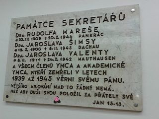
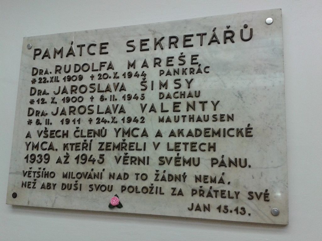
Čeština: Pamětní deska "Obětem 2. světové války" je volně přístupná a je umístěná ve vestibulu paláce YMCA v budově na adrese: Na Poříčí 1041/12; 110 00 Praha 1 – Nové Město. Pamětní deska připomíná tři sekretáře organizace YMCA, kterými byli: Rudolf Mareš (* 1909 - † 1944), Jaroslav Šimsa (* 1900 - † 1945) a Jaroslav Valenta (* 1911 - † 1942), kteří zemřeli v letech nesvobody 1939 až 1945 a kteří se účastnili protinacistického odboje. English: Memorial Plaque "Victims of WW2" is freely accessible and is located in the lobby of the palace YMCA building at the adress: Na Poříčí 1041/12; 110 00 Prague 1 - Nové Město (Czech republic). The memorial plaque recalls the three Secretary of the YMCA, which were: Rudolf Mareš (* 1909 - † 1944), Jaroslav Šimsa (* 1900 - † 1945) and Jaroslav Valenta (* 1911 - † 1942), who died in the years of oppression 1939 to 1945 and who actively participated on the anti-Nazi resistance in protectorate. |
| Date | |
| Source | Own work |
| Author | Mojmir Churavy |
| Permission (Reusing this file) |
I, the copyright holder of this work, hereby publish it under the following license: This file is licensed under the Creative Commons Attribution-Share Alike 4.0 International license.
|
| Other versions |
.jpg) |
| Camera location | | View this and other nearby images on: OpenStreetMap |
|---|
File history
Click on a date/time to view the file as it appeared at that time.
| Date/Time | Thumbnail | Dimensions | User | Comment | |
|---|---|---|---|---|---|
| current | 15:29, 17 November 2015 | | 2,560 × 1,920 (1.39 MB) | Mojmir Churavy (talk | contribs) | User created page with UploadWizard |
You cannot overwrite this file.
File usage on Commons
The following page uses this file:
File usage on other wikis
The following other wikis use this file:
- Usage on cs.wikipedia.org