File:Paneuropetransport.png
Jump to navigation
Jump to search

Size of this preview: 492 × 600 pixels. Other resolutions: 197 × 240 pixels | 394 × 480 pixels | 773 × 942 pixels.
Original file (773 × 942 pixels, file size: 32 KB, MIME type: image/png)
Captions
Captions
Add a one-line explanation of what this file represents
Summary[edit]

|
File:Pan-European corridors.svg is a vector version of this file. It should be used in place of this PNG file when not inferior.
File:Paneuropetransport.png → File:Pan-European corridors.svg
For more information, see Help:SVG. |
 |
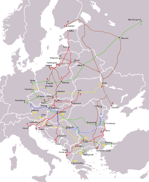
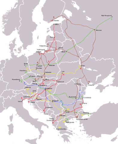
The ten Pan-European transport corridors.
Created by User:Albinfo using User:wiki-vr's blank map.
derivative works[edit]
Derivative works of this file: Pan-European corridors.svg
Licensing[edit]
| I, the copyright holder of this work, release this work into the public domain. This applies worldwide. In some countries this may not be legally possible; if so: I grant anyone the right to use this work for any purpose, without any conditions, unless such conditions are required by law. |
File history
Click on a date/time to view the file as it appeared at that time.
| Date/Time | Thumbnail | Dimensions | User | Comment | |
|---|---|---|---|---|---|
| current | 13:15, 14 August 2013 | | 773 × 942 (32 KB) | Spiridon Ion Cepleanu (talk | contribs) | Little rectifications around low-Danube |
| 08:05, 18 October 2007 |  | 773 × 942 (44 KB) | Hoshie (talk | contribs) | added Montenegro. Under same lic. as before. | |
| 23:11, 12 December 2006 |  | 773 × 942 (37 KB) | Albinfo (talk | contribs) | Fixed several errors and updated corrections in the original file - sorry for all the misleadings | |
| 20:06, 5 December 2006 |  | 773 × 941 (33 KB) | Geo-Loge~commonswiki (talk | contribs) | Ostrava => Brno, Ostrava added, Wroclaw and Krakow added | |
| 17:12, 24 June 2006 |  | 773 × 941 (28 KB) | Joy (talk | contribs) | Fixed confusion between Lviv and Uzhorod. | |
| 22:42, 30 December 2005 |  | 773 × 941 (36 KB) | Albinfo (talk | contribs) | The ten Pan-European transport corridors. Created by User:Albinfo using User:wiki-vr's blank map. |
You cannot overwrite this file.
File usage
There are no pages that use this file.
Global file usage
The following other wikis use this file:
- Usage on be.wikipedia.org
- Usage on cs.wikipedia.org
- Usage on de.wikipedia.org
- Usage on eo.wikipedia.org
- Usage on es.wikipedia.org
- Usage on fr.wikipedia.org
- Usage on sr.wikipedia.org
- Usage on sv.wikipedia.org