File:Pannonia02.png
Salta a la navegació
Salta a la cerca

Mida d'aquesta previsualització: 668 × 599 píxels. Altres resolucions: 268 × 240 píxels | 535 × 480 píxels | 1.001 × 898 píxels.
Fitxer original (1.001 × 898 píxels, mida del fitxer: 75 Ko, tipus MIME: image/png)
Llegendes
Llegendes
Afegeix una explicació d'una línia del que representa aquest fitxer
Resum
[modifica]| Descripció |
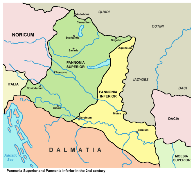
English: Historic map - Roman provinces Pannonia Superior and Pannonia Inferior in the 2nd century.
Српски / srpski: Istorijska karta - Rimske provincije Gornja Panonija i Donja Panonija u 2. veku. |
||
| Data | |||
| Font |
|
||
| Autor | PANONIAN (discussió · contribucions) |

Llicència
[modifica]
| Jo, el titular del copyright d'aquesta obra, l'allibero al domini públic. Això s'aplica a tot el món. En alguns països això pot no ser legalment possible, en tal cas: Jo faig concessió a tothom del dret d'usar aquesta obra per a qualsevol propòsit, sense cap condició llevat d'aquelles requerides per la llei. |
Historial del fitxer
Cliqueu una data/hora per veure el fitxer tal com era aleshores.
| Data/hora | Miniatura | Dimensions | Usuari/a | Comentari | |
|---|---|---|---|---|---|
| actual | 15:54, 8 abr 2010 | | 1.001 × 898 (75 Ko) | PANONIAN (discussió | contribucions) | improved version |
| 14:34, 26 jul 2007 |  | 702 × 751 (12 Ko) | Nihad Hamzic (discussió | contribucions) | Losslessly reduced the color domain to 4-bit. The file size is much smaller. | |
| 23:54, 23 des 2006 |  | 702 × 751 (39 Ko) | Electionworld (discussió | contribucions) | {{ew|en|PANONIAN}} historic map (self made) {{PD-self}} Category:Maps of the history of Vojvodina Category:Maps of the history of Serbia Category:Maps of the history of Croatia Category:Maps of the history of Bosnia and Herzegovina [[Categ |
No podeu sobreescriure aquest fitxer.
Ús del fitxer
Les 5 pàgines següents utilitzen aquest fitxer:
Ús global del fitxer
Utilització d'aquest fitxer en altres wikis:
- Utilització a af.wikipedia.org
- Utilització a ar.wikipedia.org
- Utilització a ast.wikipedia.org
- Utilització a be.wikipedia.org
- Utilització a bg.wikipedia.org
- Utilització a br.wikipedia.org
- Utilització a ca.wikipedia.org
- Utilització a cs.wikipedia.org
- Utilització a el.wikipedia.org
- Utilització a en.wikipedia.org
- Utilització a et.wikipedia.org
- Utilització a fa.wikipedia.org
- Utilització a fi.wikipedia.org
- Utilització a fr.wikipedia.org
- Utilització a fr.wiktionary.org
- Utilització a gl.wikipedia.org
- Utilització a hr.wikipedia.org
- Utilització a hu.wikipedia.org
- Utilització a it.wikipedia.org
- Utilització a ja.wikipedia.org
- Utilització a ka.wikipedia.org
- Utilització a ko.wikipedia.org
- Utilització a la.wikipedia.org
Vegeu més usos globals d'aquest fitxer.