File:Pannonian Slavic Duchy-cro.PNG
Jump to navigation
Jump to search
No higher resolution available.
Pannonian_Slavic_Duchy-cro.PNG (737 × 546 pixels, file size: 67 KB, MIME type: image/png)
Captions
Captions
Add a one-line explanation of what this file represents
| Description |
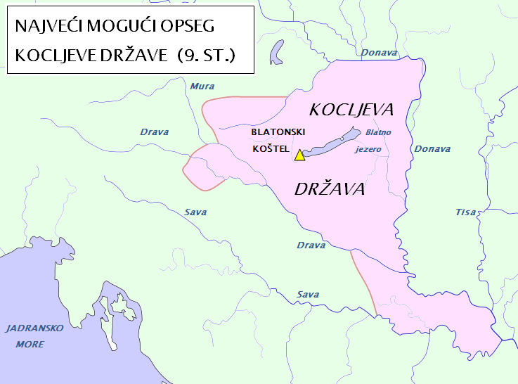
English: Lower Pannonia (Spodnja Panonija) during the reign of Kocelj (9th century); For approximate borders look at Inzko Valentin (1978): Zgodovina Slovencev do leta 1918. Mohorjeva založba, Celovec, page: 34; Čepič Zdenko et al. (1979): Zgodovina Slovencev. Cankarjeva založba, Ljubljana 1979, page: 127, 133; Peršič Janez et al. (1983): Stare kulture. Mladinska knjiga, Ljubljana, page: 144; [1]; [2]. |
| Date | (UTC) |
| Source | |
| Author |
|
![[1]](http://www.crohis.com/srkulj1/trpimir.jpg)
![[2]](http://img31.imageshack.us/img31/8313/870.png)
| This is a retouched picture, which means that it has been digitally altered from its original version. Modifications: Croatian names are used.. The original can be viewed here: Waterways of SE Central Europe.svg:
|
| I, the copyright holder of this work, release this work into the public domain. This applies worldwide. In some countries this may not be legally possible; if so: I grant anyone the right to use this work for any purpose, without any conditions, unless such conditions are required by law. |
Original upload log
[edit]
This image is a derivative work of the following images:
- File:Zemljevid_Spodnje_Panonije.PNG licensed with PD-self
- 2010-04-09T21:14:18Z Bostjan46 737x514 (64840 Bytes) {{Information |Description={{en|1=Originally: Waterways}} |Source=*[[:File:Waterways_of_SE_Central_Europe.svg|]] |Date=2010-04-09 21:11 (UTC) |Author=*[[:File:Waterways_of_SE_Central_Europe.svg|]]: [[User:Kmiki87|Kmiki87]] *d
- File:Waterways_of_SE_Central_Europe.svg licensed with PD-self
- 2010-01-08T20:49:27Z Kmiki87 1415x1059 (292577 Bytes) {{Information |Description={{en|1=Waterways along the central and lower Danube, including the Bohemian and Carpathian Basins, the northern Balkans, parts of Austria, southern Poland and Western Ukraine.}} |Source={{own}} |Aut
Uploaded with derivativeFX
File history
Click on a date/time to view the file as it appeared at that time.
| Date/Time | Thumbnail | Dimensions | User | Comment | |
|---|---|---|---|---|---|
| current | 17:10, 8 October 2011 | | 737 × 546 (67 KB) | Bostjan46 (talk | contribs) | Changes for SE borders. According to: Grafenauer Bogo (1954): Zgodovina slovenskega naroda. I. zvezek. Page 49. {{pd-self}} |
| 16:48, 10 April 2010 |  | 739 × 513 (64 KB) | Bostjan46 (talk | contribs) | {{Information |Description={{en|1=Lower Pannonia; Spodnja Panonija; For approximate borders look at Inzko Valentin (1978): Zgodovina Slovencev do leta 1918. Mohorjeva založba, Celovec, page: 34; Čepič Zdenko et al. (1979): Zgodovina Slovencev. Cankarj |
You cannot overwrite this file.
File usage on Commons
The following 2 pages use this file:
File usage on other wikis
The following other wikis use this file:
- Usage on de.wikipedia.org
- Usage on en.wikipedia.org
- Usage on hr.wikipedia.org
- Usage on pl.wikipedia.org
- Usage on pt.wikipedia.org
- Usage on ro.wikipedia.org
- Usage on ru.wikipedia.org
- Usage on sh.wikipedia.org
- Usage on tr.wikipedia.org
- Usage on uz.wikipedia.org