File:Parantaka territories.png
Jump to navigation
Jump to search
No higher resolution available.
Parantaka_territories.png (430 × 339 pixels, file size: 24 KB, MIME type: image/png)
Captions
Captions
Add a one-line explanation of what this file represents
Summary[edit]
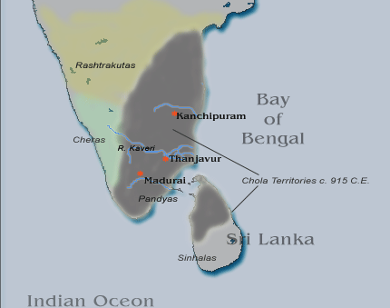
Chola Territories c. 915 C.E. this image was created using the Online Map Creation tool found at http://www.aquarius.geomar.de archive copy at the Wayback Machine and modified by me using Adobe Photoshop.
Licensing[edit]
I, the copyright holder of this work, hereby publish it under the following license:
| This file is licensed under the Creative Commons Attribution-Share Alike 3.0 Unported license. Subject to disclaimers. | ||
| ||
| This licensing tag was added to this file as part of the GFDL licensing update. |

|
Permission is granted to copy, distribute and/or modify this document under the terms of the GNU Free Documentation License, Version 1.2 or any later version published by the Free Software Foundation; with no Invariant Sections, no Front-Cover Texts, and no Back-Cover Texts. A copy of the license is included in the section entitled GNU Free Documentation License. Subject to disclaimers. |
File history
Click on a date/time to view the file as it appeared at that time.
| Date/Time | Thumbnail | Dimensions | User | Comment | |
|---|---|---|---|---|---|
| current | 03:49, 17 August 2020 | | 430 × 339 (24 KB) | Panda619 (talk | contribs) | Reverted to version as of 05:56, 13 February 2006 (UTC) |
| 13:15, 29 July 2020 |  | 430 × 303 (17 KB) | Panda619 (talk | contribs) | Reverted to version as of 02:53, 17 March 2006 (UTC) Unsourced | |
| 04:47, 2 March 2020 |  | 1,468 × 1,052 (461 KB) | StephenPaa (talk | contribs) | Corrected borders | |
| 02:53, 17 March 2006 |  | 430 × 303 (17 KB) | Venu62 (talk | contribs) | Chola Territories c. 915 C.E. this image was created using the Online Map Creation tool found at http://www.aquarius.geomar.de and modified by me using Adobe Photoshop. | |
| 05:56, 13 February 2006 |  | 430 × 339 (24 KB) | Venu62 (talk | contribs) | Chola Territories c. 915 C.E. this image was created using the Online Map Creation tool found at http://www.aquarius.geomar.de and modified by me using Adobe Photoshop. |
You cannot overwrite this file.
File usage on Commons
There are no pages that use this file.
File usage on other wikis
The following other wikis use this file:
- Usage on en.wikipedia.org
- Usage on hi.wikipedia.org
- Usage on ml.wikipedia.org
- Usage on ta.wikipedia.org
- Usage on te.wikipedia.org