File:Path 15 2.GIF
Jump to navigation
Jump to search
Size of this preview: 216 × 597 pixels. Other resolutions: 86 × 240 pixels | 500 × 1,383 pixels.
Original file (500 × 1,383 pixels, file size: 18 KB, MIME type: image/gif)
Captions
Captions
Add a one-line explanation of what this file represents
Summary
[edit]
| Description | |
| Date | Sometime in Summer of 2006. |
| Source | Own work (I created this work entirely by myself using Microsoft Paint.) |
| Author | Cheers. Trance addict - Armin van Buuren - Oceanlab |
Licensing
[edit]
Hydrogen Iodide, the copyright holder of this work, hereby publishes it under the following license:
| This file is licensed under the Creative Commons Attribution-Share Alike 3.0 Unported license. Subject to disclaimers. | ||
| Attribution: Hydrogen Iodide | ||
| ||
| This licensing tag was added to this file as part of the GFDL licensing update. |

|
Permission is granted to copy, distribute and/or modify this document under the terms of the GNU Free Documentation License, Version 1.2 or any later version published by the Free Software Foundation; with no Invariant Sections, no Front-Cover Texts, and no Back-Cover Texts. A copy of the license is included in the section entitled GNU Free Documentation License. Subject to disclaimers. |
Original upload log
[edit]
The original description page was here. All following user names refer to en.wikipedia.
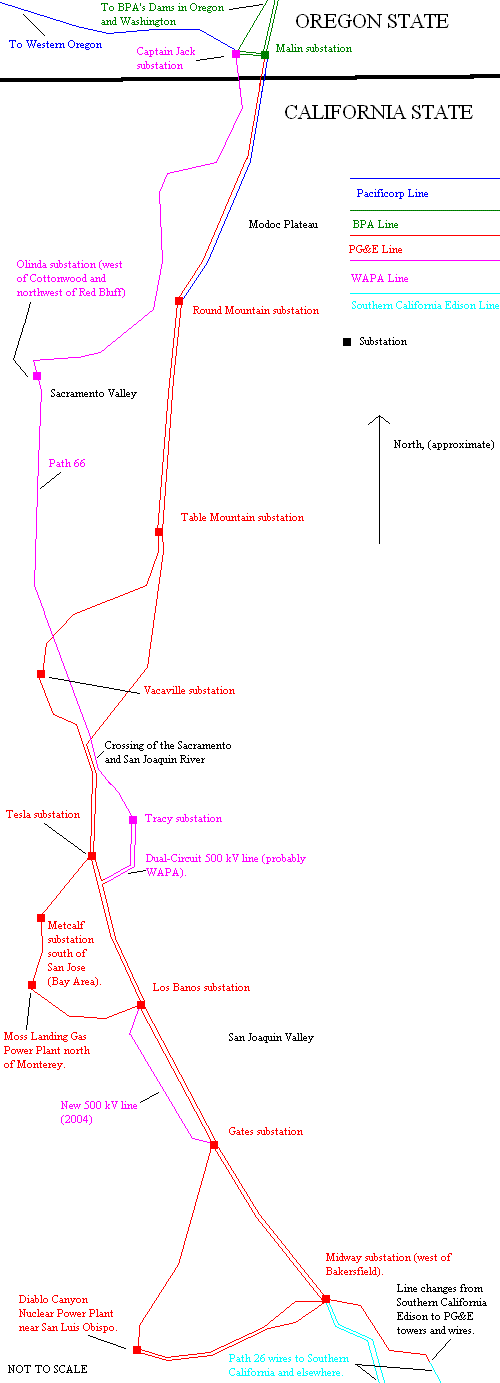
- 2006-07-23 19:20 Hydrogen Iodide 500×1383 (18585 bytes) This was created my me, using the Microsoft Paint Program. As for the map, it's completed to the best of my knowledge, but the part above Cottonwood substation and Round Mountain substation is where I'm not certain with the ownership of the wires and mayb
File history
Click on a date/time to view the file as it appeared at that time.
| Date/Time | Thumbnail | Dimensions | User | Comment | |
|---|---|---|---|---|---|
| current | 12:06, 29 January 2012 | 500 × 1,383 (18 KB) | BotMultichillT (talk | contribs) | {{BotMoveToCommons|en.wikipedia|year={{subst:CURRENTYEAR}}|month={{subst:CURRENTMONTHNAME}}|day={{subst:CURRENTDAY}}}} == {{int:filedesc}} == {{Information |description={{en|1=A map of Path 15, Path 66 and Path 26 in California and Oregon, not to scale.} |
You cannot overwrite this file.
File usage on Commons
There are no pages that use this file.
File usage on other wikis
The following other wikis use this file:
- Usage on en.wikipedia.org