File:Paul Oct 15 2012 1815Z.jpg
跳转到导航
跳转到搜索

本预览的尺寸:457 × 600像素。 其他分辨率:183 × 240像素 | 366 × 480像素 | 585 × 768像素 | 780 × 1,024像素 | 1,560 × 2,048像素 | 6,400 × 8,400像素。
原始文件 (6,400 × 8,400像素,文件大小:7.28 MB,MIME类型:image/jpeg)
说明
说明
添加一行文字以描述该文件所表现的内容
摘要
[编辑]
| 描述 |
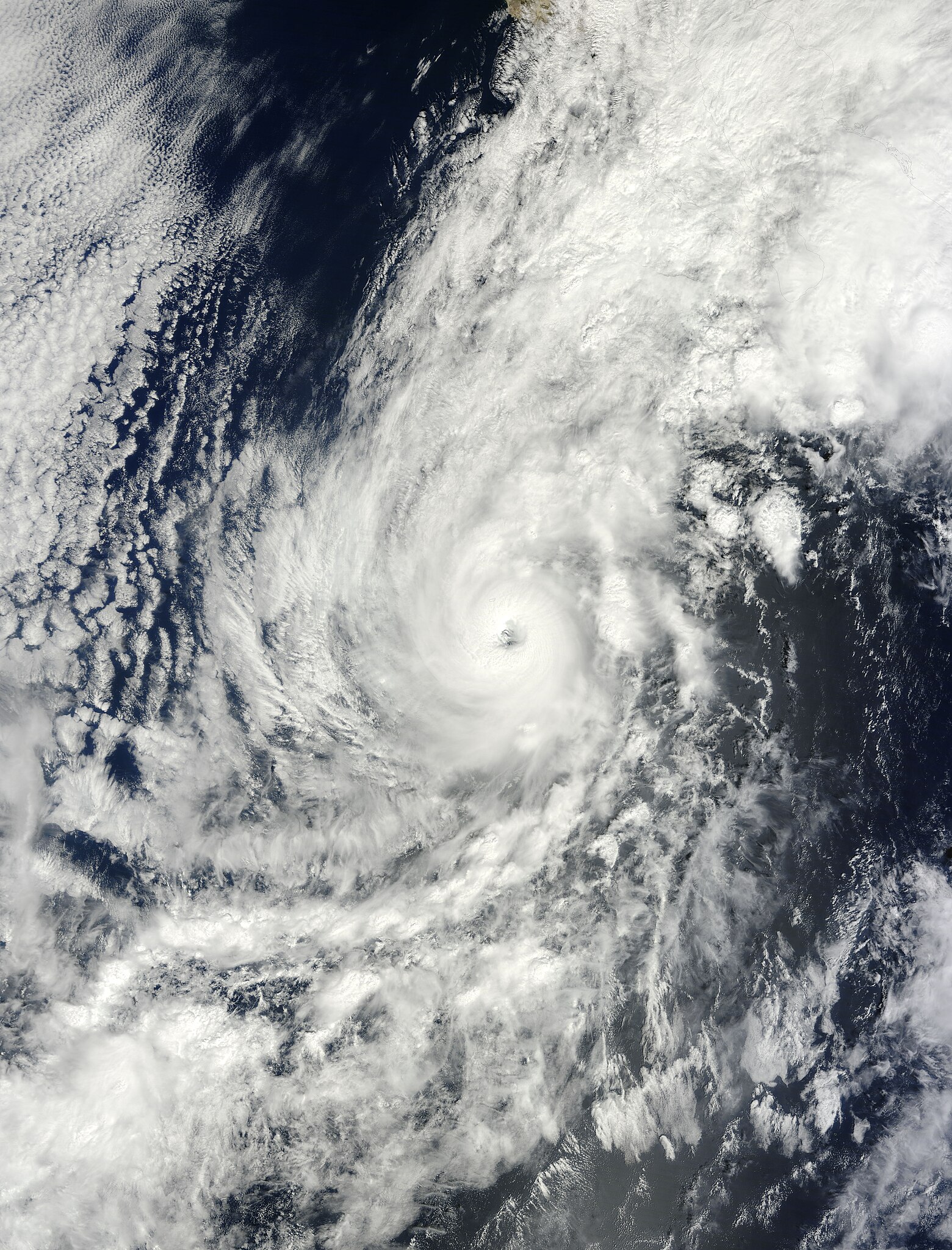
English: Paul formed as a tropical storm over the eastern Pacific Ocean on October 13, 2012. By October 15, when the Moderate Resolution Imaging Spectroradiometer (MODIS) on NASA’s Terra satellite captured this natural-color image, Paul was a hurricane bearing down on Baja California.
At roughly the same time that MODIS captured this image, the U.S. National Hurricane Center (NHC) reported that Paul had maximum sustained winds of 90 miles (150 kilometers) per hour. At 11:00 a.m. Pacific Daylight Time on October 16, Paul’s wind speeds were the same, and the center of the storm was located about 45 miles (70 kilometers) south of Cabo San Lazaro. The NHC reported that Paul was moving northwards at about 18 miles (28 kilometers) per hour, and was expected to make landfall within a few hours. The NHC warned of strong winds, heavy rains, and a dangerous storm surge for parts of Baja. |
| 日期 | |
| 来源 | https://lance.modaps.eosdis.nasa.gov/cgi-bin/imagery/single.cgi?image=Paul.A2012289.1815.2km.jpg |
| 作者 | NASA image courtesy Jeff Schmaltz, LANCE MODIS Rapid Response Team at NASA GSFC. Caption by Michon Scott. |
| 授权 (二次使用本文件) |
Public Domain |
许可协议
[编辑]
| 本文件完全由NASA创作,在美国属于公有领域。根据NASA的版权方针,NASA的材料除非另有声明否则不受版权保护。(参见Template:PD-USGov/zh、NASA版权方针页面或JPL图片使用方针。) | ||
 |
警告:
|
文件历史
点击某个日期/时间查看对应时刻的文件。
| 日期/时间 | 缩略图 | 大小 | 用户 | 备注 | |
|---|---|---|---|---|---|
| 当前 | 2023年8月25日 (五) 12:36 | | 6,400 × 8,400(7.28 MB) | Nino Marakot(留言 | 贡献) | Original image |
| 2012年10月17日 (三) 05:05 |  | 6,053 × 8,234(13.13 MB) | Earth100(留言 | 贡献) | Best version | |
| 2012年10月16日 (二) 05:24 |  | 6,000 × 8,366(6.19 MB) | Earth100(留言 | 贡献) | User created page with UploadWizard |
您不可以覆盖此文件。
文件用途
以下页面使用本文件:
- File:Paul Oct 15 2012.jpg(文件重定向)
全域文件用途
以下其他wiki使用此文件:
- de.wikipedia.org上的用途
- en.wikipedia.org上的用途
- es.wikipedia.org上的用途
- fr.wikipedia.org上的用途
- ko.wikipedia.org上的用途
- pt.wikipedia.org上的用途
- zh.wikipedia.org上的用途