File:Peking.png
Jump to navigation
Jump to search

Size of this preview: 504 × 600 pixels. Other resolutions: 202 × 240 pixels | 403 × 480 pixels | 645 × 768 pixels | 860 × 1,024 pixels | 1,720 × 2,048 pixels | 7,508 × 8,938 pixels.
Original file (7,508 × 8,938 pixels, file size: 110.47 MB, MIME type: image/png)
Captions
Captions
Add a one-line explanation of what this file represents
Summary
[edit]
| Description |
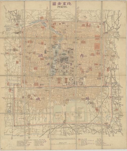
English: Peking = Beijing quan tu
Peking = 北京全圖 Street plan of the city of Beijing, dating from the early twentieth century, Map shows main roads, railways, government buildings, temples, rivers, lakes, parks and city walls. "Aufgenommen 1900/1901 von den Feldtopographen des Deutschen Ostasiatischen Expeditions-Korps." |
| Date | |
| Source | National Library of Australia Digital Collection |
| Author | Kartogr. Abteilung der kgl. Preuß. Landesaufnahme |
Licensing
[edit]
| This work of bildende Kunst (visual art) or photography was published in Germany before the Law on Copyrights and Neighboring Rights (UrhG) came into effect on January 1, 1966. It does not indicate its author and was published by a legal entity under public law (§ 5 KUG; for details see Wikipedia:Bildrechte). Therefore according to § 134 Satz 2 UrhG, copyright expires 70 years after publishing.
|
 |
File history
Click on a date/time to view the file as it appeared at that time.
| Date/Time | Thumbnail | Dimensions | User | Comment | |
|---|---|---|---|---|---|
| current | 18:31, 29 January 2022 | | 7,508 × 8,938 (110.47 MB) | Kristián Czerny (talk | contribs) | Uploaded a work by Great Britain from National Library of Australia Digital Collection with UploadWizard |
You cannot overwrite this file.
File usage on Commons
The following page uses this file: